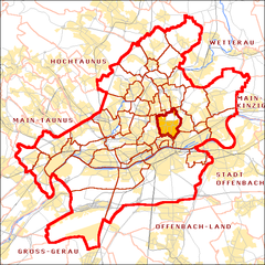
- Nordend, Frankfurt
-
Nordend Stadtteil of Frankfurt Coordinates 50°07′23″N 8°41′32″E / 50.12306°N 8.69222°ECoordinates: 50°07′23″N 8°41′32″E / 50.12306°N 8.69222°E Administration Country Germany State Hesse Admin. region Darmstadt District Urban district Town Frankfurt Basic statistics Area 4.758 km2 (1.837 sq mi) Population 54,432 (31 December 2007) - Density 11,440 /km2 (29,630 /sq mi) Other information Time zone CET/CEST (UTC+1/+2) Licence plate F Postal codes 60316, 60318, 60320, 60322, 60385, 60389 Area code 069 The Nordend is a district of the German city of Frankfurt am Main. While it officially consists of the two administrative districts (Stadtteile) Nordend-Ost and Nordend-West, the "Nordend" is normally seen as one unit by the locals who live here. It is part of the Ortsbezirk Innenstadt III.
The Nordend is the most populous district of the financial capital of Germany with more than 54,000 residents. It is a popular neighbourhood for its bohemian mix of restaurants, cafés and bars. In the 60s and 70s of the 20th century, the Nordend was one of the centers of the student riots in Germany, along with Hamburg and Berlin. The former German foreign minister's Joschka Fischer political career started here as a student leader for the Green Party. In the 2006 local elections, Fischer's Green Party became the biggest party in the local district assembly, called "Ortsbeirat". Together the two Stadtteile form part of the Ortsbezirk Innenstadt III (Frankfurt am Main).
Up until today, the Nordend has a vibrant mix of artists, working class people, students, drop-outs, and - as of recently - bankers and consultants. The students of the seventies still live here, but they are now best-agers with a high disposable income, which they spend in local wine stores and organic grocery stores.
Districts of Frankfurt - Altstadt
- Bahnhofsviertel
- Bergen-Enkheim
- Berkersheim
- Bockenheim
- Bonames
- Bornheim
- Dornbusch
- Eckenheim
- Eschersheim
- Fechenheim
- Flughafen
- Frankfurter Berg
- Gallus
- Ginnheim
- Griesheim
- Gutleutviertel
- Harheim
- Hausen
- Heddernheim
- Höchst
- Innenstadt
- Kalbach-Riedberg
- Nied
- Nieder-Erlenbach
- Nieder-Eschbach
- Niederrad
- Niederursel
- Nordend
- Oberrad
- Ostend
- Praunheim
- Preungesheim
- Riederwald
- Rödelheim
- Sachsenhausen
- Schwanheim
- Seckbach
- Sindlingen
- Sossenheim
- Unterliederbach
- Westend
- Zeilsheim
 Categories:
- Hesse geography stubs
- Districts of Frankfurt
Wikimedia Foundation. 2010.


