- Splügen Pass
-
Splügen Pass 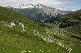
The Splügen Pass from the Swiss sideElevation 2,113 m (6,932 ft) Traversed by Road Location Location of Splügen Pass
 Splügen Pass
Location  Italy
Italy
 Switzerland
Range Alps Coordinates 46°30.36′N 09°20.22′E / 46.506°N 9.337°ECoordinates: 46°30.36′N 09°20.22′E / 46.506°N 9.337°E The Splügen Pass (German: Splügenpass; Italian: Passo dello Spluga; Latin: Cunus Aureus[1] ) (el. 2,113 m) is a high mountain pass which marks the boundary between the Lepontine and Rhaetian Alps.
It connects the Swiss Hinterrhein valley and Splügen in the canton of Graubünden with the Valle Spluga and Chiavenna in the Italian province of Sondrio, the road continuing to Lake Como. The pass is the water divide between the drainage basins of the Rhine, which flows into the North Sea, and the Po River, which flows into the Adriatic.
Since the construction of the tunnel through San Bernardino, the pass has lost its former importance; it is not kept open in winter.
The Italian counterpart of the Swiss town of Splügen is Montespluga on the Italian side of the pass. Montespluga is a small three street village which is cut off from both Italy and Switzerland during the winter.
Thanks to its lack of importance it is now a quiet pass where essential portions of the historical roads and paths have survived allowing a good historical review for hikers on Via Spluga[2].
In 1840, author Mary Shelley traveled through the pass on the way to Lake Como with her son. She describes the pass in her travel narrative, Rambles in Germany and Italy, published in 1844:
A few years ago, there was no path except across this mountain, which being very exposed, and difficult even to danger, the Splugen was only traversed by shepherds and travellers of the country on mules or on foot. But now, a new and most marvellous road has been constructed - the mountain in question is, to the extent of several miles, cleft from the summit to the base, and a sheer precipice of 4000 feet rises on either side. The Rhine, swift and strong, but in width a span, flows in the narrow depth below. The road has been constructed on the face of the precipice, now cut into the side, now perforated through the living rock into galleries: it passes, at intervals, from one side of the ravine to the other, and bridges of a single arch span the chasm. The precipices, indeed approach so near, in parts, that a fallen tree could not reach the river below, but lay wedged in mid-way. It may be imagined how singular and sublime this pass is, in its naked simplicity. After proceeding about a mile, you look back and see the country you had left, through the narrow opening of the gigantic crags, set like a painting in this cloud-reaching frame. It is giddy work to look down over the parapet that protects the road, and mark the arrowy rushing of the imprisoned river. Mid-way in the pass, the precipices approach so near that you might fancy that a strong man could leap across."[3]
See also
- List of highest paved roads in Europe
- List of mountain passes
- List of the highest Swiss passes
References
- ^ Roma Victrix
- ^ (English)Hiking Switzerland Graubünden Via Spluga
- ^ Shelley, Mary (1996). Travel Writing. London: Pickering. pp. 105. ISBN 1852960848.
External links
Categories:- Mountain passes of the Alps
- Mountain passes of Italy
- Mountain passes of Switzerland
- Italy–Switzerland border crossings
- Valle Spluga
- Geography of Lombardy
- Mountain passes of Graubünden
- Graubünden geography stubs
- Lombardy geography stubs


Wikimedia Foundation. 2010.