- Oneida Township, Delaware County, Iowa
-
Oneida Township — Township — Location in Delaware County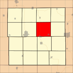
Coordinates: 42°30′56″N 91°18′36″W / 42.51556°N 91.31°WCoordinates: 42°30′56″N 91°18′36″W / 42.51556°N 91.31°W Country  United States
State  Iowa
IowaCounty Delaware Area – Total 36.63 sq mi (94.87 km2) – Land 36.63 sq mi (94.87 km2) – Water 0 sq mi (0 km2) 0% Elevation 1,020 ft (311 m) Population (2000) – Total 1,648 – Density 45/sq mi (17.4/km2) GNIS feature ID 0468465 Oneida Township is a township in Delaware County, Iowa, USA. As of the 2000 census, its population was 1,648[1].
Contents
Geography
Oneida Township covers an area of 36.63 square miles (94.87 square kilometers). The streams of Almoral Branch and Garretts Branch run through this township.
Cities and towns
Unincorporated towns
- Almoral
- Almoral Siding (historical)
- Oneida
(This list is based on USGS data and may include former settlements.)
Adjacent townships
- Elk Township (north)
- Colony Township (northeast)
- Bremen Township (east)
- Delhi Township (south)
- Milo Township (southwest)
- Delaware Township (west)
- Honey Creek Township (northwest)
Cemeteries
The township contains three cemeteries: Fairview, Pine View and Saint Josephs.
Major highways
References
External links
Municipalities and communities of Delaware County, Iowa Cities Colesburg | Delaware | Delhi | Dundee | Dyersville‡ | Earlville | Edgewood‡ | Greeley | Hopkinton | Manchester | Masonville | Ryan

Townships Adams | Bremen | Coffins Grove | Colony | Delaware | Delhi | Elk | Hazel Green | Honey Creek | Milo | North Fork | Oneida | Prairie | Richland | South Fork | Union
Unincorporated
communitiesPetersburg | Robinson | Rockville
Footnotes ‡This populated place also has portions in an adjacent county or counties
Categories:- Townships in Delaware County, Iowa

Wikimedia Foundation. 2010.