Clipsham

Clipsham

Coordinates: 52°44′N 0°34′W / 52.74°N 0.57°W / 52.74; -0.57

Clipsham
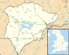
Clipsham is located in Rutland
Clipsham

 Clipsham shown within Rutland
Area  2.61 sq mi (6.8 km2[1]
Population 120 2001 Census[2]
    - Density  46 /sq mi (18 /km2)
OS grid reference SK969163
    - London  88 miles (142 km) SSE 
Unitary authority Rutland
Shire county Rutland
Ceremonial county Rutland
Region East Midlands
Country England
Sovereign state United Kingdom
Post town OAKHAM
Postcode district LE15
Dialling code 01572
Police Leicestershire
Fire Leicestershire
Ambulance East Midlands
EU Parliament East Midlands
UK Parliament Rutland and Melton
List of places: UK • England • Rutland

Clipsham is a village in the county of Rutland in the East Midlands of England.

The village is well-known for its limestone quarries. Clipsham stone,[3] part of the Upper Lincolnshire Limestone Formation, can be found in many of Britain's most famous buildings including King's College Chapel (Cambridge), the Examination Schools in Oxford, York Minster, and in repairs to the Houses of Parliament.

The Olive Branch[4] is one of the very few pubs to hold a Michelin star and in 2008 was chosen as winner of the Michelin Pub of the Year.

The Yew Tree Avenue, once the carriage drive to Clipsham Hall, is maintained by the Forestry Commission.[citation needed] Each of the trees is clipped into a different shape. This form of horticulture is called Topiary.

References

External links

Media related to Clipsham at Wikimedia Commons


Wikimedia Foundation. 2010.

Игры ⚽ Поможем решить контрольную работу

Look at other dictionaries:

  • Clipsham — This uncommon and interesting name is of Anglo Saxon origin, and is a locational surname deriving from the place called Clipsham in the former county of Rutland, near Stamford. The place is recorded in the Rutland Curia Rolls of 1203 as Kilpesham …   Surnames reference

  • Clipsham — Original name in latin Clipsham Name in other language Clipsham State code GB Continent/City Europe/London longitude 52.73608 latitude 0.56545 altitude 98 Population 0 Date 2011 07 31 …   Cities with a population over 1000 database

  • Clipsham — …   Useful english dictionary

  • Buildings of Jesus College, Oxford — Coordinates: 51°45′12.32″N 1°15′25.09″W / 51.7534222°N 1.2569694°W / 51.7534222; 1.2569694 …   Wikipedia

  • New Democratic Party candidates, 2011 Canadian federal election — This is a list of nominated candidates for the New Democratic Party in the 2011 federal election. The party s list of candidates in 2011 included the largest number of women ever nominated by a major party in an election campaign, with 123 female …   Wikipedia

  • Avocado — taxobox name = Alvacodo image caption = Avocado fruit and foliage, Huntington Library, California regnum = Plantae unranked divisio = Angiosperms unranked classis = Magnoliids ordo = Laurales familia = Lauraceae genus = Persea species = P.… …   Wikipedia

  • Oakham School — Motto Latin: Et quasi cursores vitai lampada tradunt (And, like runners, they pass on the torch of life) Established 1584 Type Independent school Religion Church of England Headmaster …   Wikipedia

  • Castle Bytham — is a picturesque village of around 300 houses in South Kesteven in south Lincolnshire at gbmapping|SK990185. Overlooking the village is an 11th century Saxon castle, which was destroyed by Henry III in 1221, even though he was only fourteen.The… …   Wikipedia

  • Palace of Westminster — Houses of Parliament redirects here. For other uses, see Houses of Parliament (disambiguation). Palace of Westminster The Palace of Westminster and Westminster Bridge viewed …   Wikipedia

  • St Albans Cathedral — Infobox UK cathedral building name =St Albans Cathedral infobox width = image size =300px caption =St Albans Cathedral from the west, showing Grimthorpe s 19th century west front map type = map size = map caption = location =St Albans full name… …   Wikipedia

Share the article and excerpts

Direct link
Do a right-click on the link above
and select “Copy Link”