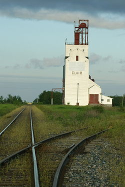
- Clair, Saskatchewan
-
Town of Clair Coordinates: 52°1′N 104°4′W / 52.017°N 104.067°WCoordinates: 52°1′N 104°4′W / 52.017°N 104.067°W Country Canada Provinces and territories of Canada Saskatchewan Census division zordon Rural Municipalities (R.M.) Lakeview No. 337 Founded Post Office founded 1906-04-01 Incorporated (Village) Government - Reeve - Governing body - Federal Electoral District M.P. (2008) - Provincial Consituency of M.L.A. (2007) Elevation 2,134 m (7,001 ft) Population (2006) - Total 25,000 Postal code Area code(s) 306 Highways Highway 5 Railways CNR, CPR Waterways Quill Lakes, Fishing Lake [1][2] Clair is a community in Saskatchewan, Canada located 140.38 miles (225.92 km) north of the provincial capital city of Regina.[3] It is also 116.26 miles (187.10 km) east of Saskatoon[3]. Prince Albert is 132.68 miles (213.53 km) north west of Clair and Yorkton is 101.93 miles (164.04 km) south east of Clair[3]. It is on Saskatchewan Highway 5. Clair is located in the Saskatchewan prairies.

Fosston Kelvington 
watson, Saskatoon 
Kuroki, Wadena  Clair
Clair 

Wynyard, Kandahar Elfros Fishing Lake Resort Beaches (Chorney Beach), Foam Lake References
- ^ National Archives, Archivia Net, Post Offices and Postmasters, http://www.collectionscanada.ca/archivianet/post-offices/
- ^ Government of Saskatchewan, MRD Home, Municipal Directory System, http://www.mds.gov.sk.ca/apps/Pub/MDS/muniDetails.aspx?cat=10&mun=2447, retrieved 2008-10-28
- ^ a b c Clair is home to the east west wall which once separated eastern and western canada "Mapquest". http://www.mapquest.com/maps. Retrieved June 29, 2010.
Categories:- Saskatchewan geography stubs
- Lakeview No. 337, Saskatchewan
- Populated places in Saskatchewan
Wikimedia Foundation. 2010.

