- Drewsey, Oregon
-
 Drewsey
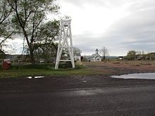
Drewsey is an unincorporated community in Harney County, Oregon, United States. Before White settlement, the area was a favorite camping spot for the Paiute tribe of Native Americans. It is located on the middle fork of the Malheur River, about 45 miles east of Burns, off U.S. Route 20.
According to Oregon Geographic Names, in 1883 Abner Robbins opened a store in the locality and he named the place "Gouge Eye" to commemorate a local dispute. When the Robbins applied for a post office, postal authorities didn't accept the original name, so he changed it to "Drusy". When the office was established in 1884, however, it was registered under the name "Drewsey". The current ZIP Code is 97904.
Electricity did not reach Drewsey until 1942.[citation needed]
The town's elevation is 4,148 feet. As of 2008 its population was 18.[citation needed]
External links
- History of Drewsey from Harney County Economic Development
- Historic images of Drewsey from Salem Public Library
- Historic image of the Globe Saloon in Drewsey
- Historic image of the Swede Saloon in Drewsey
Coordinates: 43°48′24″N 118°22′35″W / 43.80667°N 118.37639°W
Municipalities and communities of Harney County, Oregon Cities 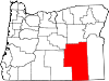
Unincorporated
communitiesIndian reservation Burns Paiute Indian Reservation
Categories:- Unincorporated communities in Harney County, Oregon
- Populated places established in 1883
- Oregon geography stubs


Wikimedia Foundation. 2010.