- Morrison's Haven
-
Morrison's Haven (or Morison's Haven) is a harbour at Prestongrange, East Lothian, Scotland, UK, on the B1348, close to Levenhall Links, Prestongrange Industrial Heritage Museum, Prestonpans, and Prestongrange House.
Contents
History
In 1526, the Cistercian monks of Holyrood Abbey and Newbattle Abbey received permission from King James V for the construction of a port in place called "Gilbertis-draucht". The monks could also collect "port monies, customs and duties". There was at least one mill, and a stone fort with underground vaults which was destroyed by Oliver Cromwell in 1650 on his way to Leith. The Abbot leased the port to Alexander Atkinsoun or Achesoun, and the port was known as "Acheson's Haven" and sometimes "New Haven" until the 17th century.
By the middle of the 18th century, the Haven was a busy port, exporting oysters, salt, local glassware, ceramics, bricks, fireclay, coal, and chemicals, including sulphuric acid. Imports were brandy from France, port wine from Portugal, Delft china from the Low countries, leather from the Baltic port Danzig, and furs from Canada. A map of 1773 shows the port having two breakwaters.
The importance of the Haven is reflected in the fact that it has customs jurisdiction over the coastline from Figgate Burn, Portobello all the way to the Tyne at Belhaven.
In the late 19th century, ships from the Baltic brought rock salt to Morrison's Haven and exchanged it for coal and other commodities.
Up to the late 1920s, the Haven exported large amounts of coal and bricks. Then it became disused, and the harbour was filled in and the site was landscaped. At the same time, Prestongrange's traditional industries declined apace.
Morrison's Haven today
The Prestongrange Community Archaeological Project, started in 2004, confirmed the importance of Morrison's Haven. 18th century glass and pottery manufacture was totally dependent on the harbour. It developed into a mechanised working port and underwent frequent repair and improvement. The PCA Project enabled local residents to learn skills related to archaeology.
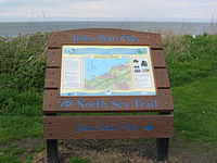
The Haven is on the route of the John Muir Way, a long-distance footpath along the East Lothian coast, starting at Fisherrow and terminating at Dunglass.
References
- Shirlaw, Jean H., "The glassworks at Morrison's Haven", Transactions of the East Lothian Antiquarian % Field Naturalists's Society, 24 (2000), 39-40. ISSN 01401637
External links
- Overview of Morrison's Haven, by East Lothian Museum Services
- Report No. 937, Prestongrange Community Archaeological Project
- "Acheson/Morrison's Haven - What came and went and how" by Julie Aitken
- Gazetteer for Scotland, Historical perspective, drawn from the Ordnance Gazetteer of Scotland, ed. Francis H. Groome, publ. 1882-85 Thomas C. Jack, Grange Publishing Works, Edinburgh
- PDF Leaflet "Happy Walks in Prestonpans", featuring Morrison's Haven
See also
Coordinates: 55°57′04″N 3°00′20″W / 55.951°N 3.0056°W
Categories:- Ports and harbours of Scotland
- East Lothian
- Lothians geography stubs
Wikimedia Foundation. 2010.


