- Forksville Covered Bridge
Geobox|Bridge
name = Forksville Covered Bridge
native_name =
category =National Register of Historic Places
image_size = 300
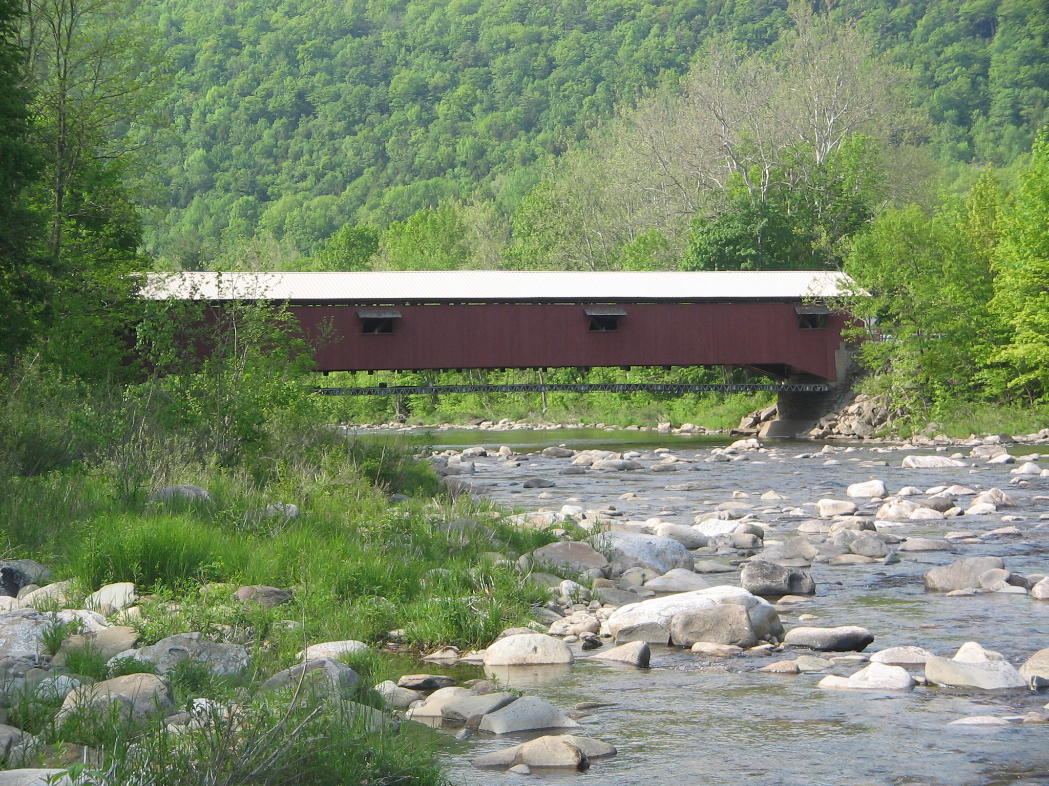
image_caption = The Forksville Covered Bridge over Loyalsock Creek
official_name = Forksville Covered Bridge
other_name =
etymology_type = Named for
etymology = Forksville
nickname =
flag_size =
symbol =
symbol_size =
country = United States
country_
state = Pennsylvania
state_
region_type = County
region = Sullivan
municipality_type = Borough
municipality = Forksville
parent_type = Road
road = State Route 4012
road_note = (single lane)
city =
landmark =
building =
river = Loyalsock Creek
river_type = Crosses
location =
elevation_imperial = 1010
lat_d = 41
lat_m = 29
lat_s = 18
lat_NS = N
long_d = 76
long_m = 36
long_s = 00
long_EW = W
coordinates_note =cite web
url = http://terraserver-usa.com/map.aspx?T=2&S=11&W=600&H=400&opt=0&Lon=-76.60015549333333&Lat=41.4881666
title = USGS Eagles Mere (PA) Topo Map
accessdate = 2008-06-06
author =United States Geological Survey
publisher =TerraServer-USA and theNational Map ]
length_imperial = 152.9
length_orientation =
length_note =
width_imperial = 15.0
width_round = 1
width_orientation =
width_note =cite web
url = http://www.arch.state.pa.us/
title = National Historic Landmarks & National Register of Historic Places in Pennsylvania
publisher = ARCH: Pennsylvania's Historic Architecture & Archeology
format = Searchable database
accessdate = 2008-06-04 "Note:" This includes cite web
url = http://www.arch.state.pa.us/pdfs/H000915_01B.pdf
title = National Register of Historic Places Inventory Nomination Form: Forksville Covered Bridge
accessdate = 2008-06-04
author = Susan M. Zacher,Pennsylvania Historical and Museum Commission
format = PDF]
width_type =
number =
number_type =
height_imperial = 8.0
height_round = 1
height_type = Clearance
height_note =
depth_imperial =
volume_imperial =
area_imperial =
style_type = Design
style = Burr arch truss bridge
material = Wood
author_type = Builder
author = Sadler Rogers (or Rodgers)
established_type = Built
established = 1850
established_note =
established1_type = Restored
established1 = 1970, 2004
management_type = Owned and maintained by
management = Pennsylvania, PennDOT
code_type = NBI Number
code_label = National Bridge Inventory identification number
code = 564012001000500
code_note =cite web|url= http://nationalbridges.com/nbi_record.php?StateCode=42&struct=564012001000500 | title = Place Name: Forksville, Pennsylvania; NBI Structure Number: 564012001000500; Facility Carried: SR 4012; Feature Intersected: Over Loyalsock Creek |author =Federal Highway Administration National Bridge Inventory |year=2006 |publisher =Nationalbridges.com (Alexander Svirsky) |accessdate = 2008-06-06 "Note": this is a formatted scrape of the 2006 official website, which can be found here for Pennsylvania: cite web| url = http://www.fhwa.dot.gov/bridge/nbi/2006/PA06.txt |title = PA06.txt |year = 2006 | publisher = Federal Highway Administration |accessdate = 2008-06-06]
code1_type = WGCB Number
code1_label = World Guide to Covered Bridges Number
code1 = 38-57-01
code1_note =cite book |last= Evans |first= Benjamin D. |coauthors= Evans, June R. |title= Pennsylvania's Covered Bridges: A Complete Guide |edition= 1st edition |year= 1993 |publisher= University of Pittsburgh Press |location= Pittsburgh, Pennsylvania |isbn= 0822955040 |pages = 255 ]
public =
visitation =
visitation_date =
access =
access_type =
whs_name =
whs_year =
whs_number =
whs_region =
whs_criteria =
iucn_category =
free_type = Load
free = 3 tons (2.7 t)
free1_type = Added to NRHP
free1 = July 24, 1980
free2_type = NRHP Ref#
free2 = 80003639
free3_type = MPS
free3 = Covered Bridges of Bradford, Sullivan and Lycoming Counties TR

map_size = 300
map_caption = Location of the Forksville Covered Bridge in Pennsylvania
map_locator = Pennsylvania
commons = Forksville Covered Bridge
statistics =
website =
footnotes = The Forksville Covered Bridge is a Burr arch trusscovered bridge overLoyalsock Creek in the borough of Forksville, Sullivan County, in the U.S. state ofPennsylvania . It was built in 1850 and is convert|152|ft|11|in in length. The bridge was placed on the National Register of Historic Places in 1980. The Forksville bridge is named for the borough it is in, which is named for its location at the confluence or "forks" of the Little Loyalsock and Loyalsock Creeks.Pennsylvania had the first covered bridge in the United States, and the most such bridges in both the 19th and 21st centuries. They were a transition between stone and metal bridges, with the roof and sides protecting the wooden structure from weather. The Forksville bridge is a Burr arch truss type, with a load-bearing
arch sandwiching multiple vertical king posts, for strength and rigidity. The building of the Forksville bridge was supervised by the 18-year-old Sadler Rogers, who used his hand-carved model of the structure. It served as the site of astream gauge from 1908 to 1913 and is still an official Pennsylvania state highway bridge. The United States Department of TransportationFederal Highway Administration uses it as the model of a covered bridge "classicgable roof", and it serves as thelogo of a Pennsylvania insurance company.The bridge was restored in 1970 and 2004 and is still in use, with average daily traffic of 217 vehicles in 2006. Despite the restorations, as of 2006 the bridge structure's sufficiency rating on the
National Bridge Inventory was only 17.4 percent and its condition was deemed "basically intolerable requiring high priority of corrective action". It is one of three remaining covered bridges in Sullivan County, and according to Susan M. Zacher's "The Covered Bridges of Pennsylvania: A Guide", its location "over the rocky Loyalsock Creek" is "one of the most attractive settings in the state."Overview
The covered bridge is in the borough of Forksville on Bridge Street, a spur of State Route 4012, just west of
Pennsylvania Route 154 . It is about convert|0.2|mi|1 south ofPennsylvania Route 87 and convert|2.0|mi|1 north ofWorlds End State Park on PA 154. [cite map |scale = 1:65,000| publisher= Pennsylvania Department of Transportation, Bureau of Planning and Research, Geographic Information Division | url= ftp://ftp.dot.state.pa.us/public/pdf/BPR_pdf_files/Maps/GHS/Roadnames/sullivan_GHSN.PDF | title= 2007 General Highway Map Sullivan County Pennsylvania | accessdate= 2008-06-06] Forksville Covered Bridge is its official name on the National Register of Historic Places (NRHP).cite web
url = http://www.nationalregisterofhistoricplaces.com/PA/Sullivan/state.html
title = National Register of Historic Places — Pennsylvania (PA), Sullivan County
publisher = www.nationalregisterofhistoricplaces.com
accessdate = 2008-06-06
authorlink =National Register of Historic Places ] Sullivan County is located in north central Pennsylvania, about 123 miles (198 km) northwest of Philadelphia and 195 miles (314 km) east-northeast of Pittsburgh.cite web | last = Michels | first = Chris | year = 1997 | url = http://www2.nau.edu/~cvm/latlongdist.html | title = Latitude/Longitude Distance Calculation |publisher = Northern Arizona University | accessdate = 2007-09-17]The bridge is just upstream of the confluence of the Little Loyalsock and Loyalsock Creeks. This was known as the "forks of the Loyalsock"cite book| url= http://www.rootsweb.com/~pasulliv/sullivancountyfolk/scf2/streby/Ingham.htm |title= History of Sullivan County, Pennsylvania: Compendium of Biography |author = Thomas J. Ingham |year = 1899 | publisher = Lewis Publishing Co. | location= Chicago, Illinois |accessdate = 2008-06-06 ] and gave Forks Township its name when the township was incorporated in 1833, while still part of Lycoming County. Sullivan County was formed from part of Lycoming County on March 14, 1847, and the bridge was built in 1850. The name of the bridge comes from the community of Forksville, which is on land first settled in 1794, was laid out as a village in 1854, and was incorporated as a borough from part of Forks Township on December 22, 1880. cite web |url = http://www.phmc.state.pa.us/bah/dam/counties/pdfs/Sullivan.pdf |title = Sullivan County 7th class | format = PDF | accessdate = 2008-06-06 |publisher = Pennsylvania Historical and Museum Commission ]
History
Background
The first covered bridge in the United States was built in 1800 over the
Schuylkill River inPhiladelphia , Pennsylvania. According to Zacher, the first covered bridges of the Burr arch truss design were also built in the state. Pennsylvania is estimated to have once had at least 1,500 covered bridges and is believed to have had the most in the country between 1830 and 1875.cite web | url = http://www.nr.nps.gov/multiples/64000708.pdf | title = National Register of Historic Places Inventory Nomination Form: Covered Bridges of Bradford, Sullivan and Lycoming Counties | accessdate = 2008-04-14 | author = Susan M. Zacher, Pennsylvania Historical and Museum Commission | format = PDF ] In 2001, Pennsylvania had more surviving historic covered bridges than any other state, with 221 remaining in 40 of its 67 counties.Covered bridges were a transition between stone and metal bridges, the latter made of cast-iron or steel. In 19th-century Pennsylvania, lumber was an abundant resource for bridge construction, but did not last long when exposed to the elements. The roof and enclosed sides of covered bridges protected the structural elements, allowing some of these bridges to survive for well over a century. A Burr arch truss consists of a load-bearing
arch sandwiching multiple king posts, resulting in stronger and more rigid structure than one made of either element alone.Construction and description
Although there were 30 covered bridges in Sullivan County in 1890, only five were left by 1954, and as of 2008 only three remain: Forksville, Hillsgrove, and Sonestown. All three are Burr arch truss covered bridges and were built in 1850. The Forksville Covered Bridge was built for Sullivan County by Sadler Rogers (or Rodgers), a native of Forksville who was only 18 at the time. He hand-carved a model of the bridge before work began and used it to supervise construction.cite book | title = Sullivan County Industries: Now and Then | year = 1954 | publisher = The Endicott Printing Company |location = Endicott, New York |url = http://www.rootsweb.ancestry.com/~pasulliv/SullivanCountyHistoricalSociety/SullivanIndustries.htm] Rogers built the Forksville and Hillsgrove bridges across Loyalsock Creek, with the latter about convert|5|mi downstream of the former. Although most sources do not list the builder of the Sonestown bridge, a 1997 newspaper article on the remaining Sullivan County covered bridges reported that Rodgers had designed it also.cite news |first= Mollie |last= Eliot |title= Sullivan County's Covered Bridges Survive But Their Numbers Are Down From 30 to Three Today |publisher= "Williamsport Sun-Gazette" |date=
December 28 ,1997 ]The Forksville Covered Bridge was added to the NRHP in 1980 and was listed on the 2006 National Bridge Inventory (NBI). According to the NBI, the covered bridge is convert|152|ft|11|in|m long, with a roadway convert|12|ft|2|in|m wide, and a maximum load of convert|3.0|ST|metric_ton|1. According to the NRHP, the bridge's "road surface width" is convert|15|ft|1, which is only sufficient for a single lane of traffic. As of 2008, each portal has a small sign reading "1850 Sadler Rogers" at the top, above a sign with the posted clearance height of convert|8.0|ft|1, and a "No Trucks Allowed" sign hanging below these. [Note: Follow these links for photographs of the .]
The covered bridge rests on the original stone
abutment s, which have since been reinforced with concrete. The bridge deck, which is now supported by steel beams, is made of "very narrow crosswise planks". Wheel guards on the deck separate the roadway from the pedestrian walkways on either side and protect the sides, which are covered with vertical planks almost to theeaves .cite news |title= Covered Bridge at Forksville Being Renovated: Old Covered Bridge Just 'Oozing' History |publisher= "Grit" (City News Edition) |date=September 13 ,1970 "Note": a photo in the article clearly shows one long side of the bridge without any windows and several boards missing] The bridge has long, narrow windows with wooden shutters: the south side has four windows, and the north side has three. An opening between the eaves and the siding runs the length of the bridge on both sides. The bridge is supported by a Burr arch truss of 16 panels, with wooden beams. The gable roof issheet metal and is used as the model illustration of a "classic gable roof" for a covered bridge by theU.S. Department of Transportation Federal Highway Administration Turner-Fairbank Highway Research Center.cite web| url = http://www.tfhrc.gov/structur/pubs/04098/06.htm |author = Pierce, Phillip C.; Brungraber, Robert L.; Lichtenstein, Abba; Sabol, Scott | title = Covered Bridge Manual: Chapter 6. Ancillary Features, Publication No. FHWA-HRT-04-098 | month = April | year = 2005 | publisher =Federal Highway Administration Turner-Fairbank Highway Research Center | accessdate = 2008-06-06 ]Restoration and use
In the 19th century the Forksville Covered Bridge survived major floods on March 1, 1865, and June 1, 1889, that destroyed other bridges in the West Branch Susquehanna River valley.cite book
last = Meginness
first = John Franklin
title = History of Lycoming County, Pennsylvania: including its aboriginal history; the colonial and revolutionary periods; early settlement and subsequent growth; organization and civil administration; the legal and medical professions; internal improvement; past and present history of Williamsport; manufacturing and lumber interests; religious, educational, and social development; geology and agriculture; military record; sketches of boroughs, townships, and villages; portraits and biographies of pioneers and representative citizens, etc. etc."
year = 1892
url = http://www.usgennet.org/usa/pa/county/lycoming/history/lyco-history-01.html
accessdate = 2006-03-16
edition = 1st Edition
publisher = Brown, Runk & Co.
location = Chicago, IL
id = ISBN 0-7884-0428-8
chapter = Chapter XIX. Internal Improvements.
chapterurl = http://www.usgennet.org/usa/pa/county/lycoming/history/Chapter-19.html "Note:" ISBN refers to the Heritage Books July 1996 reprint. URL is to a scan of the 1892 version with some OCR typos.] Between about 1870 and 1890, logging in the Loyalsock Creek watershed produced lumber rafts that floated beneath the bridge. These rafts, each containing 5,000–30,000 board feet (11.8–70.8 m³) of lumber, were carried down the Loyalsock to its mouth at Montoursville, and some continued on the West Branch Susquehanna River beyond. The rafts ended when theeastern hemlock were all clearcut. [cite news |title= Lumber Still King at Forksville but Methods Have Gone Long Way Since Old Rafting Days |publisher= "Williamsport Sun" |date=August 3 ,1950 ]From 1908 to 1913, there was a
stream gauge on the bridge. Twice a day, the creek height was read on a chain convert|21.88|ft|2 long on the bridge's upstream side, and discharge measurements were taken on the downstream side. At the time it served as a "single span, wooden, covered highway bridge". [cite book | title = Annual Report of the Water Supply Commission of Pennsylvania: 1913 | pages = pp. 139–140 |url = http://books.google.com/books?id=0-8NAAAAYAAJ&pg=RA3-PA139&dq=Forksville+Covered+Bridge+Pennsylvania&lr=#PRA3-PA139,M1 |accessdate = 2008-06-08 |year = 1914 |publisher = Wm. Stanley Ray, State Printer |location = Harrisburg, Pennsylvania] The bridge survived another major flood on November 16, 1926, when a dam broke upstream [cite news |title= Dam Breaks, Flood Imperils Forksville, Pa.; Sheriff Sends Warning; Town Fails to Reply |publisher= "The New York Times" |date=November 17 1926 |page= 1 ] but was "badly damaged" by an ice jam on January 23, 1959, in a flood that left blocks of ice weighing up to convert|500|lb in the streets of Forksville. [cite news |title= Thousands Homeless as Floods and Snow Sweep East and Midwest |publisher= "The New York Times" |date=January 23 1959 |page= 1 ]The Forksville Covered Bridge was restored in 1970 with what the NRHP nomination form describes as "all kinds of odd repairs". The restoration work was completed by T. Corbin Lewis of Hillsgrove Township, a retired electrical contractor, whose low bid of USD$48,000 was accepted over a
Baltimore, Maryland , firm's $185,000 bid. The restoration was supervised by thePennsylvania Department of Transportation (PennDOT), which owns and maintains the bridge. The repair involved minor work on the "steel floor beams and stringers", which had been added years before. An entirely new wooden deck was installed, with wheel guards (wooden curbs) to channel vehicle traffic to the center and to protect the pedestrian walkways on the sides. Windows were cut in the bridge's sides for the first time, and steel girders were "added to support the bridge's understructure."Attitudes towards covered bridges in Sullivan County changed considerably in the last half of the 20th century. Two of the five bridges remaining in 1954 were razed by 1970, when PennDOT considered tearing down the Forksville bridge too. It was renovated rather than razed because of its historic nature and appeal to tourists. The Forksville Covered Bridge was added to the NRHP in 1980, and the
Pennsylvania Historical and Museum Commission now forbids the destruction of any covered bridge on the NRHP in the state and has to approve any renovation work.cite news |first= Nancy E. |last= Baumgartner |title= Cogan House Covered Bridge Dedication Follows Facelift |publisher= "Williamsport Sun-Gazette " |date=November 1 ,1998 ]The NBI says the bridge was "reconstructed" in 2004 but does not give further details. The entire bridge has been reinforced with steel girders, including vertical beams. In 2006 the bridge was painted red, which took about three weeks. [cite web | url = http://www.dot.state.pa.us/Penndot/Districts/district3.nsf/f99071963d03038c8525692f0041a9ac/47d371c9cbb5e409852572f1004d74c6?OpenDocument |title = Forksville Covered Bridge repainting starts this week; Short detour required |date =
June 5 2006 | publisher = Pennsylvania Department of Transportation | accessdate = 2008-06-06]The bridge's condition was described as "good" in the 1980 NRHP form, Zacher's 1994 book, and the Evans' 2001 book. However, the 2006
Federal Highway Administration National Bridge Inventory found the sufficiency rating of the bridge structure to be 17.4 percent.Ref_label|A|a|none It found that the bridge's foundations were "determined to be stable for calculated scour conditions" but that the railing "does not meet currently acceptable standards". Its overall condition was deemed "basically intolerable requiring high priority of corrective action", with an estimated cost to improve the bridge of $463,000.Today the Forksville Covered Bridge is heavily used, as it is the most direct and shortest route from PA 154, at the eastern end, to Forksville and its
general store , which are at the western end. In 2000, Forksville had 147 residents. [cite web|url= http://factfinder.census.gov/servlet/SAFFFacts?_event=Search&geo_id=&_geoContext=&_street=&_county=Forksville%2C+PA&_cityTown=Forksville%2C+PA&_state=&_zip=&_lang=en&_sse=on&pctxt=fph&pgsl=010&show_2003_tab=&redirect=Y |title= Fact Sheet: Forksville borough, Pennsylvania | publisher =U.S. Census Bureau | accessdate = 2008-06-25] The posted speed limit is convert|15|mph, and its average daily traffic was 217 vehicles in 2006. The bridge is used as the logo of the Farmers & Mechanics Mutual Insurance Company, which was founded in Sullivan County in 1877. [cite web |url = http://www.fmmutual.com/logo.shtml |title = About our logo | publisher = Farmers & Mechanics Mutual Insurance Company | accessdate = 2008-06-15]In addition to its utility, the bridge is appreciated for its history and beauty. In 1970 a long-time Forksville resident spoke of the bridge's connection to the past: "When you stand quiet on the bridge and the woods are still, you can almost hear the horses clomping over the wooden deck as they did in years gone by; you can almost see the youngsters who climbed the rafters of the bridge to 'skinny-dip' in the creek below", while Zacher's 1994 "The Covered Bridges of Pennsylvania: A Guide" describes the bridge's location "over the rocky Loyalsock Creek" as "one of the most attractive settings in the state."
Bridge dimensions
The following table is a comparison of published measurements of length, width and load recorded in different sources using different methods, as well as the name or names cited. The NBI measures bridge length between the "backwalls of abutments" or pavement grooves and the roadway width as "the most restrictive minimum distance between curbs or rails". The NRHP form was prepared by the
Pennsylvania Historical and Museum Commission (PHMC), which surveyed county engineers, historical and covered bridge societies, and others for all the covered bridges in the commonwealth. The Evans visited every covered bridge in Pennsylvania in 2001 and measured each bridge's length (portal to portal) and width (at the portal) for their book. The data in Zacher's book was based on a 1991 survey of all covered bridges in Pennsylvania by the PHMC and the Pennsylvania Department of Transportation, aided by local government and private agencies. The article uses primarily the NBI and NRHP data, as they are national programs.ee also
*
List of bridges on the National Register of Historic Places in Pennsylvania Notes
:a. Note_label|A|a|noneThe National Highway Administration established the sufficiency rating, which can vary from a low of 0 to a high of 100, as a way to prioritize federal funding for bridges. The rating is calculated based on "structural adequacy, whether the bridge is functionally obsolete, and level of service provided to the public". [cite web| url = http://www.transportation.org/?siteid=93&pageid=2496 | title = Bridge Inspection Definitions |publisher = American Association of State Highway and Transportation Officials |accessdate = 2008-07-12] Federal funds are available for replacement of bridges with a rating of 50 or below, while those with a rating of 80 or below qualify for rehabilitation. [cite web | url = http://www.transportation.org/sites/bridges/docs/Sufficiency%20Ratings%20Explained.pdf | title = Bridge Sufficiency Ratings | publisher = Kansas Department of Transportation |accessdate = 2008-07-12] In 2007, Pennsylvania had 22,291 bridges over convert|20|ft long, of which 42.9 percent were either structurally deficient or functionally obsolete. [cite web | url = http://www.msnbc.msn.com/id/20093413/ | title = State by State: 'Deficient' or 'Obsolete' Bridges | publisher = MSNBC.com | date =August 2 2007 |accessdate = 2008-07-12 ]References
External links
*cite web| author = Pierce, Phillip C.; Brungraber, Robert L.; Lichtenstein, Abba; Sabol, Scott; Morrell, J.J.; Lebow, S.T. | url = http://www.tfhrc.gov/structur/pubs/04098/04098.pdf |format = PDF | title = Covered Bridge Manual: Publication No. FHWA-HRT-04-098 | month = April | year = 2005 | publisher = US Department of Transportation,
Federal Highway Administration , Turner-Fairbank Highway Research Center | accessdate = 2008-06-26

Wikimedia Foundation. 2010.