- Ozleworth
-
Coordinates: 51°38′23″N 2°18′04″W / 51.6397°N 2.3012°W
Ozleworth 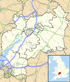
 Ozleworth
Ozleworth shown within GloucestershireParish Ozleworth District Cotswold Shire county Gloucestershire Region South West Country England Sovereign state United Kingdom Post town WOTTON-UNDER-EDGE Postcode district GL12 Dialling code 01453 Police Gloucestershire Fire Gloucestershire Ambulance Great Western EU Parliament South West England UK Parliament Cotswold List of places: UK • England • Gloucestershire Ozleworth is a village and civil parish in Gloucestershire, England, approximately 30 km (19 mi) south of Gloucester. It lies in the Cotswolds, an Area of Outstanding Natural Beauty.
Contents
History
Ozleworth was known as Oslan wyrth in 940, derived from the Old English words ōsle + worth. meaning either "enclosure of a man named Ōsla" or "enclosure frequented by blackbirds".[1] It was listed as Osleworde in the Domesday Book of 1086.[2]
Governance
Ozleworth is part of the Grumbolds Ash ward of the district of Cotswold and is currently represented by Councillor Carolyn Nicolle, a member of the Conservative Party.[3] Ozleworth is part of the constituency of Cotswold, represented at parliament by Conservative MP Geoffrey Clifton-Brown.[4] It is part of the South West England constituency of the European Parliament.
Geography
Ozleworth is in the county of Gloucestershire, and lies within the Cotswolds, a range of hills designated an Area of Outstanding Natural Beauty. It is approximately 30 km (19 mi) south of Gloucester and approximately 32 km (20 mi) south west of Cirencester. Ozelworth's post town Wotton-under-Edge is approximately 4 km (2.5 mi) to the west. Nearby villages include Alderley, Wortley, Tresham, Leighterton, Lasborough, Newington Bagpath, Owlpen, and Kingscote.
Newark Park
Newark Park is a National Trust property which was once a Tudor hunting lodge built by the Poyntz family.
Church
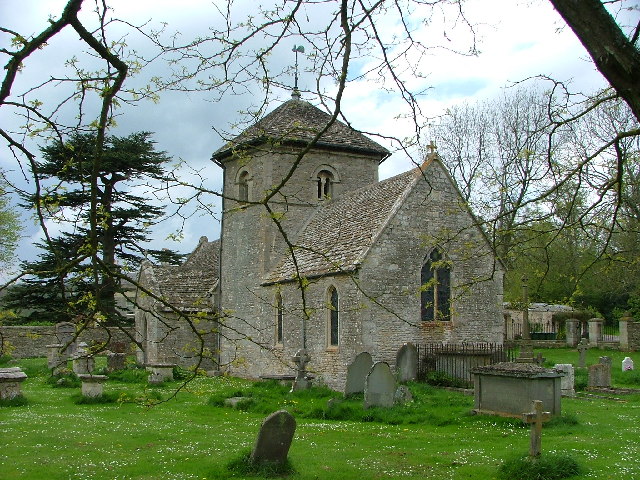
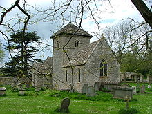 St. Nicholas church
The Norman church, which is dedicated to St. Nicholas of Myra, is known to have been in existence in 1131. It has a cruciform structure, with one bell.[5] It has an unusual hexagonal tower located in the centre of the church between the nave and the chancel.[6][7] The current nave and font were added in the early 13th century.[6] Archaeological evidence suggests that there was no nave before this time and that the tower originally formed part of the western wall of the church.[8] The churchyard is circular. No longer active, the church is looked after by the Churches Conservation Trust.
Notable people
English poet, translator and academic Charles Tomlinson lives in the village with his family.[9] Bruce Chatwin, novelist and travel writer, lived in a farmhouse in the village.
References
- ^ Mills, A. D. (1998). Dictionary of English Place-Names. Oxford University Press. pp. 265. ISBN 0192800744.
- ^ "Ozleworth". Domesday Book. The National Archives. 1086. http://www.nationalarchives.gov.uk/documentsonline/details-result.asp?Edoc_Id=7577133&queryType=1&resultcount=1. Retrieved 2008-05-09.
- ^ "Cotswold - Find Your Councillor". Cotswold District Council. http://www.cotswold.gov.uk/nqcontent.cfm?a_id=1948&tt=cotswold. Retrieved 2008-04-29.
- ^ "Cotswold - Constituency - Conservative Party". Conservative Party. http://www.conservatives.com/tile.do?def=people.constituency.page&obj_id=1396. Retrieved 2008-04-26.
- ^ "Extract from National Gazetteer, 1868". GENUKI. http://www.genuki.org.uk/big/eng/GLS/Ozleworth/Gaz1868.html. Retrieved 2008-05-31.
- ^ a b Hall, Michael (1993). Stratford-Upon-Avon and the Cotswolds. The Pevensey Press. pp. 91. ISBN 0907115683. http://books.google.co.uk/books?id=GopyAAAACAAJ.
- ^ British Archaeological Association (1847). The Archaeological Journal. Oxford University. pp. 107. http://books.google.co.uk/books?id=6TMGAAAAQAAJ.
- ^ Fernie, Eric (2000). The Architecture of Norman England. Oxford University Press. pp. 243. ISBN 0199250812. http://books.google.co.uk/books?id=jMURu7Hfx6kC.
- ^ "Charles Tomlinson - In Conversation With David Morley". 1991. http://www.poetrymagazines.org.uk/magazine/record.asp?id=2550. Retrieved 2008-06-04.
External links
 Media related to Ozleworth at Wikimedia CommonsCategories:
- Villages in Gloucestershire
- Cotswold (district)
- Gloucestershire geography stubs

Wikimedia Foundation. 2010.