- Bridgewater Bridge
Infobox_Bridge
bridge_name=Bridgewater Bridge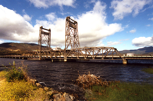
caption=The Bridgewater Bridge, over the Derwent river between the towns of Granton and Bridgewater.
official_name=
carries=
crosses= Derwent River
locale=Hobart ,Tasmania
maint= Department of Infrastructure, Energy and Resources
id=
design= Vertical lift
mainspan=
length=
width=
height=
clearance=
below=
traffic=
open=1946
closed=
toll=
map_cue=
map_
map_text=
map_width=
coordinates=coord|42|44|27|S|147|13|31|E
lat=
long=The Bridgewater Bridge and Causeway spans the Derwent River in
Tasmania ,Australia between Bridgewater and Granton. It consists of a vertical lift bridge and a specially-builtcauseway connecting the bridge to the east bank of the river. It accommodates a two-lanehighway , a single trackrailway and, on the bridge section, a footpath. As the bridge is the major connector of the Midland Highway on the eastern shore and theBrooker Highway on the western, the lifting of the bridge can cause considerable traffic delays, depending on the time of day and season.History
The Bridgewater Bridge was one of the first bridges constructed in Tasmania following British settlement in 1803, and gave its name to the nearby suburb of Bridgewater,
Hobart . Lieutenant-Governor George Arthur commissioned the construction of the bridge and causeway as part of the Launceston-Hobart Trunk Road, linking both Tasmanian towns and providing easier access to farmlands in the interior of Tasmania.The causeway
Construction commenced on the bridge in 1829. The causeway, which was constructed first, was built by a workforce of 200
convict s who had been condemned to secondary punishment. These convicts, using nothing but wheelbarrows, shovels and picks and sheer muscle power, shifted 2 million tonnes (2,204,622 t) of soil, stones and clay. The finished causeway stretched 1.3 kilometres (0.8 mi), although did not span the full width of the Derwent. The original plan apparently called for aviaduct , but this plan was abandoned and the half-built arches were filled in to form the present causeway.The first bridges
Upon completion of the causeway, a punt operated across the deep, navigable section of the river, but could not cope with traffic demands. To resolve this issue, the first bridge across this point of the Derwent opened in 1849. Being a
swing bridge , it could pivot out of the way to allow ships to pass. In the late 1870s, the Launceston-Hobart Railway called for modifications to the causeway so they could lay tracks over it. The causeway required widening and the swing bridge was modified as well.On
22 July ,1886 , a train from the north was passing over the bridge when the engine left the tracks and tipped over, hanging precariously above the water on the edge of the southern end of the swing bridge. The fireman and driver were injured, but no-one was killed and the locomotive survived. The cause of the accident was found to be that the rails failed to match properly when the bridge was closed, so the bridge was modified again to solve this problem. The bridge lasted several decades more before being replaced by another swing bridge in the early 1900s. The pivot and the sandstone abutments of this bridge are still standing and can be viewed on the left of the present bridge as one travels towards the north.Both the first and second swing bridges did not run straight off the end of the causeway; rather, they turned slightly to the right. The second swing bridge was left standing when the present lifting bridge was being constructed to prevent traffic stoppages, so the present bridge deviates from the causeway quite appreciably.
The current lift bridge
Construction on the present steel vertical lift bridge across the Derwent began in 1939. It was briefly interrupted by
World War II , but was finally completed in 1946. It consists of a long concrete bridge that leads off the end of the causeway, and a steel lifting section just before the northern bank of the river. The lifting section is one of only a few remaining in theSouthern Hemisphere , and is the largest of its kind remaining in Australia. The bridge was designed to last a century without replacement. A small contrrol house stands on the lifting section. Inside are the switches and locks which operate the bridge.Until 1984, the Australian Newsprint Mills (now
Norske Skog Paper) at Boyer, near New Norfolk, upstream from Bridgewater, moved all its produce by river. Manybarge s were used to transport paper from the mill to the storage sheds at Pavilion Point at Hobart, and for this reason the bridge was required to open very frequently. Consequently, a bridge-keeper lived on-site and opened and closed the bridge when required. However, when the decision was made to cease river transportation, an on-site keeper was no longer necessary, so although the bridge can and does still open, bridge openings are now infrequent.In response to vandalism of the house which contains the bridge operating controls,
closed-circuit television cameras were installed along the lifting span sometime between 2003 and 2005.On
October 30 2006 a fault was found in one of the steel cables holding up the two 170-tonne concrete counterweights above the road, forcing the temporary closure of the bridge. This closure caused peak hour traffic delays, mainly along theEast Derwent Highway , due to traffic being diverted over the Bowen and Tasman Bridges. The cables, which were put in place in 1994, were supposed to have a 20-year lifespan, and as they have lasted barely over half that time, investigations are underway as to the maintenance procedures of the bridge.Replacement
Since
2001 The Federal Government declared $100 million towards the replacement of the Bridgewater Bridge, soon after the State government decided to build the replacement to the south of the existing bridge. However, after years of inaction the State government has more recently taken a softer stance on the bridge and is now investigating the cost of its refurbishment.References
* [http://www.walkabout.com.au/locations/TASBridgewater.shtml Walkabout Australian Travel Guide]
External links
* [http://images.statelibrary.tas.gov.au/Search/Search.asp?Keywords=Bridgewater+Bridge&x=13&y=9|State Library of Tasmania Images] , historic pictures of the Bridgewater Bridge and Causeway
* [http://www.railtasmania.com/photogal/showimage.php?id=143| RailTasmania] , modern picture of the Bridgewater Bridge and Causeway
Wikimedia Foundation. 2010.