- Nagbukel, Ilocos Sur
-
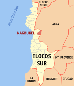
Nagbukel — Municipality — Map of Ilocos Sur showing the location of Nagbukel. Location in the Philippines Coordinates: 17°27′N 120°33′E / 17.45°N 120.55°ECoordinates: 17°27′N 120°33′E / 17.45°N 120.55°E Country  Philippines
Region Ilocos Region (Region I) Province Ilocos Sur District 2nd District Founded Barangays 12 Government – Mayor Timoteo M. Cabrera Area – Total 43.12 km2 (16.6 sq mi) Population (2007) – Total 4,764 – Density 110.5/km2 (286.1/sq mi) Time zone PST (UTC+8) ZIP code 2725 Income class 5th class Population Census of Nagbukel Census Pop. Rate 1995 4,124 — 2000 4,671 2.71% 2007 4,764 0.27% Nagbukel is a 5th class municipality in the province of Ilocos Sur, Philippines. According to the latest census, it has a population of 4,764 people in 910 households.
Barangays
Nagbukel is politically subdivided into 12 barangays.
- Balaweg
- Bandril
- Bantugo
- Cadacad
- Casilagan
- Casocos
- Lapting
- Mapisi
- Mission
- Poblacion East
- Poblacion West
- Taleb
Origin of the Municipality's Name
The name of the municipality was thought to have come from the round shape of one of the hills in the area. People in the area would utter, "Anian nga nagbukel" (Ilocano, "How round it is.").
Another origin of the municipality's name comes from three small hills in the southern part of the municipality.
Another origin of the town's name comes from the irregular distribution of the barangays of Nagbukel and nearby Narvacan. Negotiations were made in such a way that the place east of the Kayapa River become part of Nagbukel and places west of the river become part of Narvacan. The distance from north to south was equal to the distance from east to west. The resulting area is round, hence the name "Nagbukel."
External links
- Pasyalang Ilocos Sur
- Philippine Standard Geographic Code
- 1995 Philippine Census Information
- 2000 Philippine Census Information
- 2007 Philippine Census Information
Categories:- Municipalities of Ilocos Sur
Wikimedia Foundation. 2010.


