- Manito, Albay
-
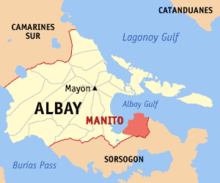 Map of Albay showing the location of Manito
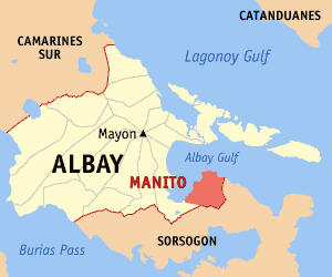
Manito is a 4th class municipality in the province of Albay, Philippines. According to the 2007 census, it has a population of 21,652 people in 3,776 households.
MANITO is located on the eastern part of Albay, elevated as plateau facing Legazpi City, on the west of the Albav Gulf and surrounded by mountains on the east and south.
The poblacion is just a stone's throw away from the seashore. It is hounded between two rivers, the Camanitohan and Buyo rivers that serve as irrigation for small rice fields and sources of the residents.
Contrary to the people of this small town believe, the first settlers in the area came from Bacon, Cagraray Island or Casiguran which are geographically situated near Manito. In prehistoric time, the Bicolanos from the above mentioned places had shown evidence of civilization. Recently artifacts unearthed from this place both by Filipino and foreign anthropologist show that Bicol is indeed inhabited first by Bicolanos, not traders from foreign lands.
In 1840, a few settlers the Visayas came and settled in the place near the coast of Manito, because of fear from Moro invaders. They officially established the place and named it Manito, because it was abounding in clinging vine called "nito”, which belongs to the rattan family and is used as raw material for making baskets. When nito vines are artistically made into baskets, the finished products are very beautiful because of the natural dark brown color similar to the color of coffee. The prefix "Ma” means plenty,then Manito means "plenty of nito".
Later, natives form the neighboring towns of Albay, Bacon, and Rapu-rapu who fled from the Moro raiders found a safer place near the seashore and near the thick west Of Manito. In the past this town was surrounded by thick forest that gave natural fiction — a haven of safety and comfort — to the Visayan settlers. Although they were brave and courageous, they lacked arms and ammunitions to fight the Moros.
In the early years of settlement, the center of this place that soon became the Poblacion had only a fear scattered houses surrounded to pour in, the forests were awed. The cleared areas were planted with abaca and other crops. Due to the abundance of food and money which the people earned through the sale of their forest and agricultural products, Manito became a progressive settlement. But today it is left behind by neighboring towns. This is probable due to its poor natural location and lack of industry. Forests are mostly denuded due to concession granting permission in the awn of trees in 1980s, while replanting of trees was neglected. Perhaps, if nito vines had been planted together with other forest trees, the income atone for this industry might be one of the major source of the residents these days.
The patron saint of this town is St. Rafael the Archangel whose feast day is celebrated every 24 day of October.
In 1882, the municipality of Manito emerged in the limelight by virtue of PD k.20364 establishing Manito as reservation area for Geothermal Exploration and development On June 1904, the BACMAN Geothermal Project has started its full operation and on October 80,1998, his Excellency President Joseph Estrada inaugurated the additional 1.5 megawatt power/multi-crop drying plant located at Pawa, Manito in support of his food security program.
Barangays
Manito is politically subdivided into 15 barangays.
- Balabagon
- Balasbas Fabricante Estate
- Bamban Fabricante Estate
- Buyo Fabricante Estate
- Cabacongan
- Cavit
- Cawayan Fabricante Estate
- Cawit
- Holugan
- It-Ba (Pob.)
- Malobago
- Manumbalay
- Nagotgot Fabricante Estate
- Pawa
- Tinapian
External links
Municipalities Component cities Legazpi • Ligao • TabacoCategories:- Municipalities of Albay
Wikimedia Foundation. 2010.