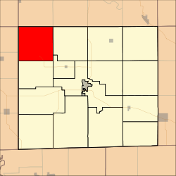
- Marion Township, Davis County, Iowa
-
Marion Township — Township — Location in Davis County Coordinates: 40°51′11″N 92°35′01″W / 40.85306°N 92.58361°WCoordinates: 40°51′11″N 92°35′01″W / 40.85306°N 92.58361°W Country  United States
State  Iowa
IowaCounty Davis Area – Total 35.66 sq mi (92.35 km2) – Land 35.31 sq mi (91.46 km2) – Water 0.34 sq mi (0.89 km2) 0.96% Elevation 906 ft (276 m) Population (2000) – Total 218 – Density 6.2/sq mi (2.4/km2) GNIS feature ID 0468350 Marion Township is a township in Davis County, Iowa, USA. As of the 2000 census, its population was 218.
Contents
Geography
Marion Township covers an area of 35.66 square miles (92.35 square kilometers); of this, 0.34 square miles (0.89 square kilometers) or 0.96 percent is water. The streams of Pee Dee Creek, Pepper Creek and South Soap Creek run through this township.
Unincorporated towns
- Ash Grove
- Blackhawk
(This list is based on USGS data and may include former settlements.)
Adjacent townships
- Adams Township, Wapello County (north)
- Green Township, Wapello County (northeast)
- Soap Creek Township (east)
- Drakesville Township (southeast)
- Fox River Township (south)
- Udell Township, Appanoose County (southwest)
- Union Township, Appanoose County (west)
- Urbana Township, Monroe County (northwest)
Cemeteries
The township contains eight cemeteries: Adams, Bailey, Edwards, Glassburner, Hanson, Mounts, Wesley Chapel and Wheeler.
References
External links
Municipalities and communities of Davis County, Iowa Cities Bloomfield | Drakesville | Floris | Pulaski
Townships Cleveland | Drakesville | Fabius | Fox River | Grove | Lick Creek | Marion | Perry | Prairie | Roscoe | Salt Creek | Soap Creek | Union | West Grove | Wyacondah
Unincorporated
communityCategories:- Townships in Davis County, Iowa
- Iowa geography stubs
Wikimedia Foundation. 2010.

