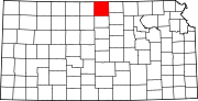
Montana Township, Jewell County, Kansas
- Montana Township, Jewell County, Kansas
-
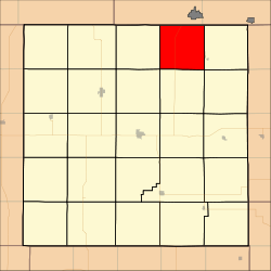
Montana Township is a township in Jewell County, Kansas, USA. As of the 2000 census, its population was 93.
Geography
Montana Township covers an area of 36.43 square miles (94.35 square kilometers); of this, 0.05 square miles (0.13 square kilometers) or 0.14 percent is water.
Adjacent townships
Cemeteries
The township contains one cemetery, Montana.
Major highways
References
External links
Categories:
- Townships in Jewell County, Kansas
- North Central Kansas geography stubs
Wikimedia Foundation.
2010.
Look at other dictionaries:
Odessa Township, Jewell County, Kansas — Odessa Township Township Location in Jewell County … Wikipedia
Richland Township, Jewell County, Kansas — Infobox Settlement official name = Richland Township settlement type = Township nickname = motto = imagesize = image caption = image imagesize = image caption = image mapsize = map caption = Location in Jewell County mapsize1 = map caption1 =… … Wikipedia
Sinclair Township, Jewell County, Kansas — Infobox Settlement official name = Sinclair Township settlement type = Township nickname = motto = imagesize = image caption = image imagesize = image caption = image mapsize = map caption = Location in Jewell County mapsize1 = map caption1 =… … Wikipedia
Jackson Township, Jewell County, Kansas — Infobox Settlement official name = Jackson Township settlement type = Township nickname = motto = imagesize = image caption = image imagesize = image caption = image mapsize = map caption = Location in Jewell County mapsize1 = map caption1 =… … Wikipedia
Harrison Township, Jewell County, Kansas — Infobox Settlement official name = Harrison Township settlement type = Township nickname = motto = imagesize = image caption = image imagesize = image caption = image mapsize = map caption = Location in Jewell County mapsize1 = map caption1 =… … Wikipedia
Holmwood Township, Jewell County, Kansas — Infobox Settlement official name = Holmwood Township settlement type = Township nickname = motto = imagesize = image caption = image imagesize = image caption = image mapsize = map caption = Location in Jewell County mapsize1 = map caption1 =… … Wikipedia
National Register of Historic Places listings in Kansas — Kansas counties There are 1,249 buildings, sites, districts, and objects in Kansas listed on the National … Wikipedia
Kansas — For other uses, see Kansas (disambiguation). State of Kansas … Wikipedia
National Register of Historic Places listings in Carroll County, New Hampshire — Location of Carroll County in New Hampshire This is a list of the National Register of Historic Places listings in Carroll County, New Hampshire. This is intended to be a complete list of the properties and districts on the National Register of… … Wikipedia
United States — a republic in the N Western Hemisphere comprising 48 conterminous states, the District of Columbia, and Alaska in North America, and Hawaii in the N Pacific. 267,954,767; conterminous United States, 3,022,387 sq. mi. (7,827,982 sq. km); with… … Universalium