- Promise Island (Nunavut)
-
Promise Island (Nannuyuma) 
Geography Location Hudson Bay Coordinates 63°22′N 90°32′W / 63.367°N 90.533°WCoordinates: 63°22′N 90°32′W / 63.367°N 90.533°W Highest elevation 300 ft (90 m) Country Nunavut  Nunavut
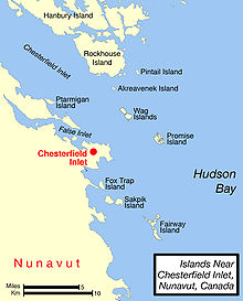
Region Kivalliq Demographics Population Uninhabited Promise Island (Inuktitut: Nannuyuma; meaning: "polar bear")[1]) is located near the western shore of Hudson Bay.[2] It is barely a square kilometer in area,[3] and rises 300 ft (91 m) in elevation on its northern side.[4] It is located about 9 km (5.6 mi)[5] from the community of Chesterfield Inlet, Nunavut, Canada, and is part of a loose chain of small islands running along the coast, including the Wag Islands and Pitsiulartok (Fairway Island).
The island is home to a wide range of wildlife, including the arctic fox (alopex lagopus innuitus), the harbor seal (phoca hispida), the polar bear, the brown lemming (lemmus t. trimucronatus), the barren-ground caribou (rangifer arcticus), and the red phalarope.[6][7]
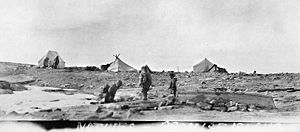
 "Natives, Promise Island" Photo c. 1920-25 by Hudson's Bay Company employee Capt. George Cleveland of the motor schooner Fort Chesterfield.
References
- ^ Arctic Institute of North America. "Field Notes on Mammals of the Chesterfield Inlet District of Keewatin". ucalgary.ca. http://pubs.aina.ucalgary.ca/arctic/Arctic23-1-49.pdf. Retrieved 2008-04-15.
- ^ "Promise Island, Nunavut, Canada". travelingluck.com. http://travelingluck.com/North%20America/Canada/Nunavut/_6113645_Promise+Island.html#themap. Retrieved 2008-04-15.
- ^ "63°22'N 90°32'W". http://maps.google.com/. Retrieved 2008-04-15.
- ^ Geological Survey of Canada. Annual Report. google.com. http://books.google.com/books?id=hKQMAAAAYAAJ&pg=RA1-PA80&dq=%22Promise+Island%22&client=firefox-a#PRA1-PA80,M1. Retrieved 2008-04-16.
- ^ "Geographic features & Photographs around Chesterfield Inlet, in Nunavut, Canada". travelingluck.com. http://travelingluck.com/North%20America/Canada/Nunavut/_5921048_Chesterfield+Inlet.html#themap. Retrieved 2008-04-15.
- ^ Arctic Institute of North America. "Field Notes on Mammals of the Chesterfield Inlet District of Keewatin". ucalgary.ca. http://pubs.aina.ucalgary.ca/arctic/Arctic23-1-49.pdf. Retrieved 2008-04-16.
- ^ Arctic Institute of North America. "Observations on the Breeding Behaviour of Phalaropes". ucalgary.ca. http://pubs.aina.ucalgary.ca/arctic/Arctic21-1-40.pdf. Retrieved 2008-04-16.
Islands of the Kivalliq Region Islands of Chesterfield Inlet Akreavenek · Apqusiurniq · Boulder · Camp Cove · Centre · Deer · Hanbury · Illusive · Iripajuk · Moor · North Imilit · North Midway · Pintail · Reference · Rockhouse · South Imilit · South Midway · WagIslands of Foxe Basin Islands of Hudson Bay Aiqqujat · Airartuuq · Austin · Bibby · Broken · Coats · Dunne Foxe · East Pen · Flattop · Imiligaarjuk · Imilijjuaq · Irik · Ivuniraarjuq · Kayak · Marble · Pitsiulartok · Promise · Sentry · Southampton · WalrusSee also Islands of the Kitikmeot Region, Islands of the Qikiqtaaluk RegionCategories:- Islands of Hudson Bay
- Uninhabited islands of Kivalliq Region
- Kivalliq Region, Nunavut geography stubs
Wikimedia Foundation. 2010.
