- Pitsiulartok
Infobox Islands
name =Pitsiulartok
(Formerly "Fairway Island")
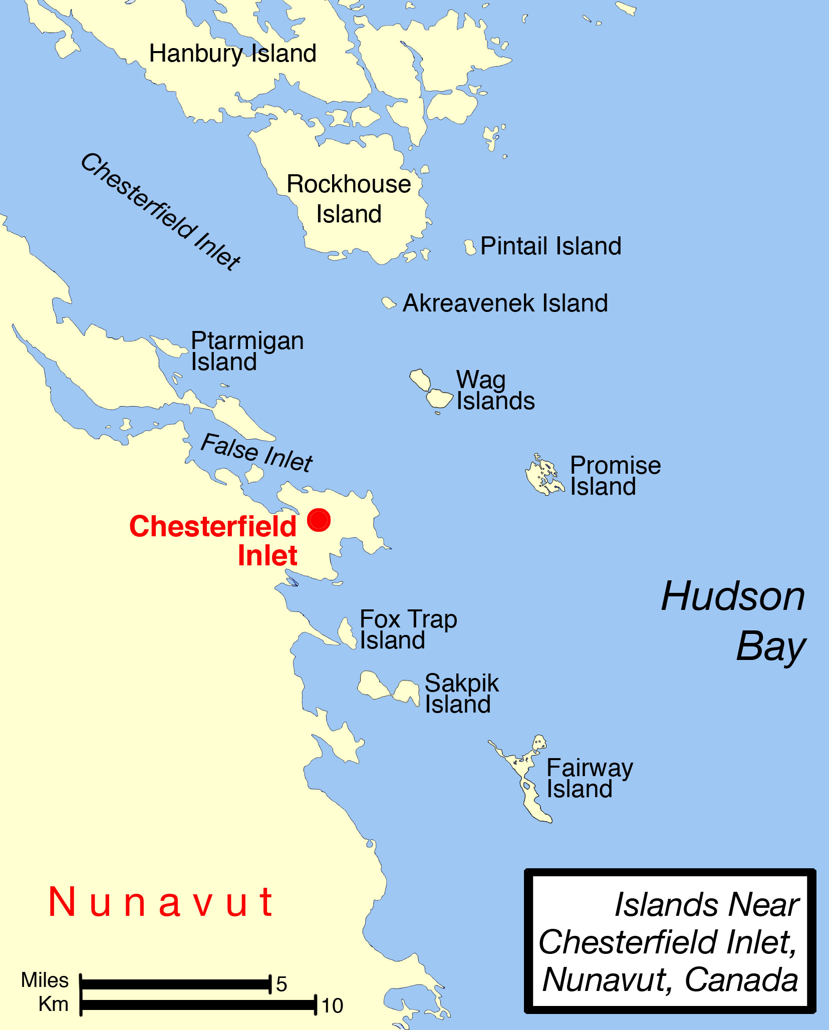
image caption =
image size =
locator
native name =
native name link =
nickname =
location =Northern Canada
coordinates = coord|63|15|N|90|33|W|display=inline,title
archipelago =
total islands =
major islands =
area =
highest mount =
elevation =
country = Canada
country admin divisions title = Nunavut
country admin divisions = flag|Nunavut
country admin divisions title 1 =Kivalliq Region
country admin divisions 1 =
country admin divisions title 2 =
country admin divisions 2 =
country capital city =
country largest city =
country largest city population =
country leader title =
country leader name =
country 1 =
country 1 admin divisions title =
country 1 admin divisions =
country 1 capital city =
country 1 largest city =
country 1 largest city population =
country 1 leader title =
country 1 leader name =
country 2 =
country 2 admin divisions title =
country 2 admin divisions =
country 2 capital city =
country 2 largest city =
country 2 largest city population =
country 2 leader title =
country 2 leader name =
population = Uninhabited
population as of =
density =
ethnic groups =Pitsiulartok or Pituilaktok, formerly known as "Fairway Island" [cite web |url=http://explorenorth.com/library/weekly/aa092599.htm |title=Renaming the North |accessdate=2008-04-15 |last= |first= |coauthors= |date= |work= |publisher=] , is a small, uninhabited island located at 63°15'N, 90°33'W [cite journal|coauthors=COSEWIC COMMITTEE ON THE STATUS OF ENDANGERED WILDLIFE IN CANADA |title=COSEWIC Assessment and Update Status Report on the Atlantic Walrus Odobenus rosmarus rosmarus in Canada|location=Ottawa, ON|issue=2006] in Hudson Bay, about 13km [cite web |url=http://travelingluck.com/North%20America/Canada/Nunavut/_5921048_Chesterfield+Inlet.html#themap |title=Geographic features & Photographs around Chesterfield Inlet, in Nunavut, Canada |accessdate=2008-04-15 |last= |first= |coauthors= |date= |work= |publisher=] from the community of
Chesterfield Inlet ,Nunavut ,Canada , and is part of a loose chain of small islands running along the coast, including Sakpik Island and Promise Island. The narrow island is about 3.5 km in length and barely 1 km wide at its widest point. [cite web|url=maps.google.com|title=63°15'N, 90°33'W|accessdate=2008-04-15] Traditionally it was a walrus-hunting ground for the localInuit , [cite journal|coauthors=COSEWIC COMMITTEE ON THE STATUS OF ENDANGERED WILDLIFE IN CANADA |title=COSEWIC Assessment and Update Status Report on the Atlantic Walrus Odobenus rosmarus rosmarus in Canada|location=Ottawa, ON|issue=2006] and a landmark for southern whalers. [cite book|last=Barr|first=William|title=Red Serge and Polar Bear Pants: The Biography of Harry Stallworthy,|publisher=University of Alberta|date=2004|isbn=0888644337|url=http://books.google.com/books?id=4PlnI7eDFrgC&pg=PA59&lpg=PA59&dq=%22Fairway+Island%22+%2BChesterfield&source=web&ots=rev4qlUdxU&sig=sWB6QpUHwQoRFPrdXZEh-rT_SCs&hl=en]The name "Pituilaktok" comes from the Inuktitut name for a local bird known in English as the
black guillemot ("cepphus grylle"), "pitiula". [cite web |url=pubs.aina.ucalgary.ca/arctic/Arctic22-1-72.pdf |title=Eskimo Bird Names at Chesterfield Inlet and Baker Lake, Keewatin, Northwest Territories |accessdate=2008-04-15 |last=Arctic Institute of North America |first= |coauthors= |date= |work= |publisher=]References
Wikimedia Foundation. 2010.