- Cowen, West Virginia
-
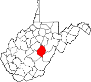
Cowen, West Virginia — Town — Location of Cowen, West Virginia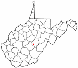
Coordinates: 38°24′38″N 80°33′21″W / 38.41056°N 80.55583°WCoordinates: 38°24′38″N 80°33′21″W / 38.41056°N 80.55583°W Country United States State West Virginia County Webster Area – Total 0.6 sq mi (1.6 km2) – Land 0.6 sq mi (1.6 km2) – Water 0.0 sq mi (0.0 km2) Elevation 2,270 ft (692 m) Population (2000) – Total 513 – Density 819.8/sq mi (316.5/km2) Time zone Eastern (EST) (UTC-5) – Summer (DST) EDT (UTC-4) ZIP code 26206 Area code(s) 304 FIPS code 54-18412[1] GNIS feature ID 1554208[2] Cowen is a town in Webster County, West Virginia, United States. The population was 513 at the 2000 census.
Contents
History
Camp Caesar was listed on the National Register of Historic Places in 2009.[3]
Geography
Cowen is located at 38°24′38″N 80°33′21″W / 38.41056°N 80.55583°W (38.410605, -80.555695)[4].
According to the United States Census Bureau, the town has a total area of 0.6 square miles (1.6 km²), all land.
Demographics
As of the census[1] of 2000, there were 513 people, 224 households, and 148 families residing in the town. The population density was 819.8 inhabitants per square mile (314.4/km²). There were 264 housing units at an average density of 421.9 per square mile (161.8/km²). The racial makeup of the town was 99.61% White, 0.19% African American, and 0.19% from two or more races. Hispanic or Latino of any race were 0.39% of the population.
There were 224 households out of which 29.9% had children under the age of 18 living with them, 49.1% were married couples living together, 12.5% had a female householder with no husband present, and 33.5% were non-families. 29.5% of all households were made up of individuals and 14.3% had someone living alone who was 65 years of age or older. The average household size was 2.29 and the average family size was 2.80.
In the town the population was spread out with 23.4% under the age of 18, 8.2% from 18 to 24, 25.5% from 25 to 44, 26.7% from 45 to 64, and 16.2% who were 65 years of age or older. The median age was 40 years. For every 100 females there were 90.7 males. For every 100 females age 18 and over, there were 83.6 males.
The median income for a household in the town was $21,250, and the median income for a family was $30,147. Males had a median income of $26,389 versus $15,139 for females. The per capita income for the town was $10,893. About 19.1% of families and 27.0% of the population were below the poverty line, including 39.7% of those under age 18 and 11.6% of those age 65 or over.
References
- ^ a b "American FactFinder". United States Census Bureau. http://factfinder.census.gov. Retrieved 2008-01-31.
- ^ "US Board on Geographic Names". United States Geological Survey. 2007-10-25. http://geonames.usgs.gov. Retrieved 2008-01-31.
- ^ "National Register of Historic Places Listings". Weekly List of Actions Taken on Properties: 1/04/10 through 1/08/10. National Park Service. 2010-01-15. http://www.nps.gov/nr/listings/20100115.htm.
- ^ "US Gazetteer files: 2010, 2000, and 1990". United States Census Bureau. 2011-02-12. http://www.census.gov/geo/www/gazetteer/gazette.html. Retrieved 2011-04-23.
Municipalities and communities of Webster County, West Virginia Towns Camden-on-Gauley | Cowen | Webster Springs
CDP Unincorporated
communitiesCategories:- Towns in West Virginia
- Populated places in Webster County, West Virginia


Wikimedia Foundation. 2010.