- Palouse, Washington
Infobox Settlement
official_name = Palouse, Washington
settlement_type =City
nickname =
motto =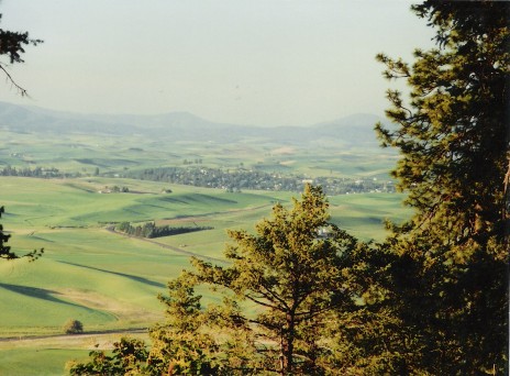
imagesize = 250px
image_caption = Palouse from Kamiak Butte
image_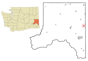
mapsize = 250px
map_caption = Location of Palouse, Washington
mapsize1 =
map_caption1 =subdivision_type = Country
subdivision_name =United States
subdivision_type1 = State
subdivision_name1 =Washington
subdivision_type2 = County
subdivision_name2 = Whitmangovernment_footnotes =
government_type =
leader_title =
leader_name =
leader_title1 =
leader_name1 =
established_title =
established_date =unit_pref = Imperial
area_footnotes =area_magnitude =
area_total_km2 = 2.8
area_land_km2 = 2.8
area_water_km2 = 0.0
area_total_sq_mi = 1.1
area_land_sq_mi = 1.1
area_water_sq_mi = 0.0population_as_of = 2000
population_footnotes =
population_total = 1011
population_density_km2 = 364.8
population_density_sq_mi = 944.8timezone = Pacific (PST)
utc_offset = -8
timezone_DST = PDT
utc_offset_DST = -7
elevation_footnotes =
elevation_m = 742
elevation_ft = 2434
latd = 46 |latm = 54 |lats = 36 |latNS = N
longd = 117 |longm = 4 |longs = 31 |longEW = Wpostal_code_type =
ZIP code
postal_code = 99161
area_code = 509
blank_name = FIPS code
blank_info = 53-52950GR|2
blank1_name = GNIS feature ID
blank1_info = 1531058GR|3
website =
footnotes =Palouse is a city in Whitman County,
Washington ,United States . The population was 1,011 at the 2000 census and a 2008 Washington Office of Financial Management estimate of 1,025.Palouse is named for the region of farmland in which it is situated, and was founded between 1890 and 1900. The current mayor of Palouse is Michael Echanove.History
Incorporated in 1888.
Historical Population
U.S. Census Bureau
1890....1,119
1900......929
1910....1,549
1920....1,179
1930....1,151
1940....1,028
1950....1,036
1960......926
1970......948
1980....1,005
1990......915
2000....1,011
2008....1,025 (Washington State Office of Financial Management Estimate)
Geography
Palouse is located at coor dms|46|54|36|N|117|4|31|W|city (46.909996, -117.075259)GR|1.
According to the
United States Census Bureau , the city has a total area of 1.1square mile s (2.8km² ), all of it land.Demographics
As of the
census GR|2 of 2000, there were 1,011 people, 432 households, and 288 families residing in the city. Thepopulation density was 944.8 people per square mile (364.8/km²). There were 471 housing units at an average density of 440.2/sq mi (170.0/km²). The racial makeup of the city was 95.94% White, 0.99% Native American, 0.30% Asian, 0.99% from other races, and 1.78% from two or more races. Hispanic or Latino of any race were 1.68% of the population.There were 432 households out of which 31.5% had children under the age of 18 living with them, 53.0% were married couples living together, 10.9% had a female householder with no husband present, and 33.3% were non-families. 28.9% of all households were made up of individuals and 10.9% had someone living alone who was 65 years of age or older. The average household size was 2.34 and the average family size was 2.88.
In the city the population was spread out with 26.9% under the age of 18, 5.7% from 18 to 24, 30.4% from 25 to 44, 23.9% from 45 to 64, and 13.1% who were 65 years of age or older. The median age was 38 years. For every 100 females there were 94.0 males. For every 100 females age 18 and over, there were 93.0 males.
The median income for a household in the city was $34,583, and the median income for a family was $41,125. Males had a median income of $30,804 versus $25,515 for females. The
per capita income for the city was $15,754. About 8.6% of families and 9.5% of the population were below thepoverty line , including 9.2% of those under age 18 and 18.7% of those age 65 or over.References
External links
* [http://www.the-boomerang.com/ The Boomerang! - Local newspaper]
* [http://www.visitpalouse.com/ Palouse official website]

Wikimedia Foundation. 2010.