- Rock Island, Washington
Infobox Settlement
official_name = Rock Island, Washington
settlement_type =City
nickname =
motto =
imagesize =
image_caption =
image_
imagesize =
image_caption =
image_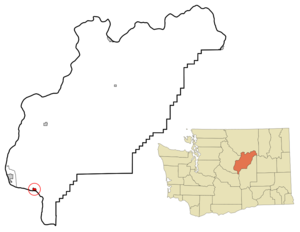
mapsize = 250px
map_caption = Location of Rock Island, Washington
mapsize1 =
map_caption1 =subdivision_type = Country
subdivision_name =United States
subdivision_type1 = State
subdivision_name1 =Washington
subdivision_type2 = County
subdivision_name2 = Douglasgovernment_footnotes =
government_type =
leader_title =
leader_name =
leader_title1 =
leader_name1 =
established_title =
established_date =unit_pref = Imperial
area_footnotes =area_magnitude =
area_total_km2 = 1.6
area_land_km2 = 1.5
area_water_km2 = 0.1
area_total_sq_mi = 0.6
area_land_sq_mi = 0.6
area_water_sq_mi = 0.0population_as_of = 2000
population_footnotes =
population_total = 867
population_density_km2 = 564.0
population_density_sq_mi = 1460.9timezone = Pacific (PST)
utc_offset = -8
timezone_DST = PDT
utc_offset_DST = -7
elevation_footnotes =
elevation_m = 196
elevation_ft = 643
latd = 47 |latm = 22 |lats = 28 |latNS = N
longd = 120 |longm = 8 |longs = 36 |longEW = Wpostal_code_type =
ZIP code
postal_code = 98850
area_code = 509
blank_name = FIPS code
blank_info = 53-59180GR|2
blank1_name = GNIS feature ID
blank1_info = 1525135GR|3
website =
footnotes =Rock Island is a city in Douglas County,
Washington ,United States . It is part of the 'Wenatchee, Washington Metropolitan Statistical Area'. The population was 863 at the 2000 census.History
Rock Island was officially incorporated on
December 8 ,1930 . The site had been previously settled in the late 19th Century and was known as Hammond. The site was thought to be the area where the large city of the area would develop as it was located near the Rock Island Rapids and near the bridge which spanned the Columbia River for the Great Northern Railroad. Despite the strategic advantages therein, the large city of the area would become Wenatchee, just seven miles upriver from the site of present-day Rock Island. The nearby Rock Island Rapids would become the site of the first hydroelectric dam on the Columbia River and spur growth in the tiny hamlet. During World War II a silicon smelter would be built in the town of Rock Island closing in 1999.Geography
Rock Island is located at coor dms|47|22|28|N|120|8|36|W|city (47.374458, -120.143247)GR|1.
According to the
United States Census Bureau , the city has a total area of 0.6square mile s (1.6km² ), of which, 0.6 square miles (1.5 km²) of it is land and 0.04 square miles (0.1 km²) of it (6.35%) is water.Demographics
As of the
census GR|2 of 2000, there were 863 people, 270 households, and 204 families residing in the city. Thepopulation density was 1,460.9 people per square mile (564.8/km²). There were 276 housing units at an average density of 467.2/sq mi (180.6/km²). The racial makeup of the city was 74.16% White, 0.81% African American, 1.51% Native American, 0.70% Asian, 20.39% from other races, and 2.43% from two or more races. Hispanic or Latino of any race were 30.59% of the population.There were 270 households out of which 45.9% had children under the age of 18 living with them, 59.3% were married couples living together, 12.2% had a female householder with no husband present, and 24.4% were non-families. 18.5% of all households were made up of individuals and 6.3% had someone living alone who was 65 years of age or older. The average household size was 3.20 and the average family size was 3.66.
In the city the population was spread out with 35.7% under the age of 18, 9.8% from 18 to 24, 29.0% from 25 to 44, 17.1% from 45 to 64, and 8.3% who were 65 years of age or older. The median age was 29 years. For every 100 females there were 96.1 males. For every 100 females age 18 and over, there were 94.7 males.
The median income for a household in the city was $33,618, and the median income for a family was $34,408. Males had a median income of $24,773 versus $19,602 for females. The
per capita income for the city was $14,129. About 11.6% of families and 11.6% of the population were below thepoverty line , including 10.4% of those under age 18 and 30.4% of those age 65 or over.References
External links
Wikimedia Foundation. 2010.