- Rock Island Swing Bridge
-
Rock Island Swing Bridge 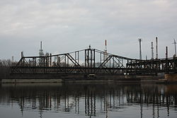
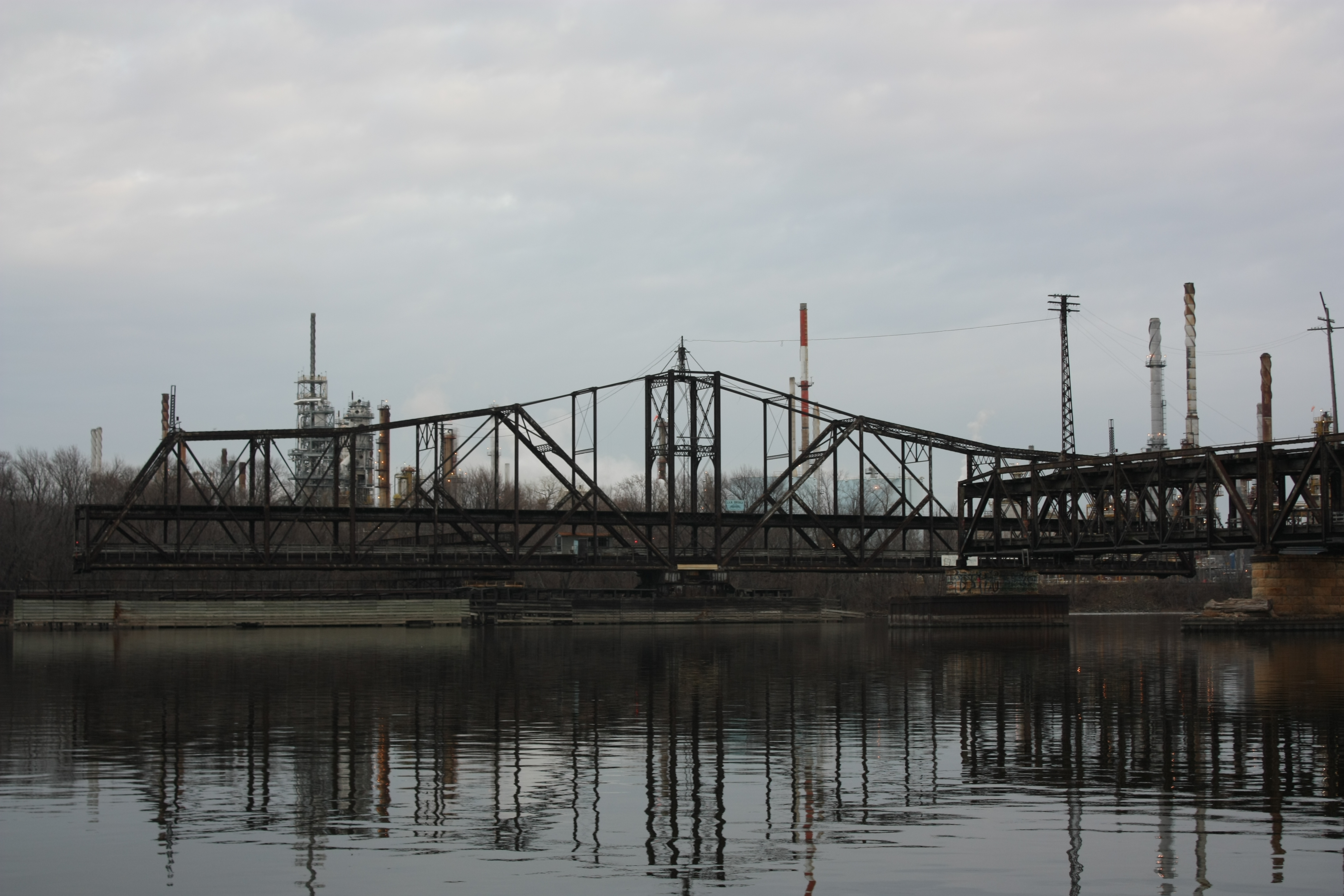
The bridge in the open position, taken from the marina directly north of bridge.Carries One and a half lanes of Washington CSAH 22, CSAH 38, and Dakota CSAH 24 and one railroad track Crosses Mississippi River Locale Inver Grove Heights, Minnesota, St. Paul Park, Minnesota Maintained by Washington County, Minnesota, Dakota County, Minnesota ID number 5600 Design Double-deck through-truss swing span Total length 1,661 feet (506 m) Width 18 feet (5.5 m) Longest span 442 feet (135 m) Clearance below 19 feet (5.8 m) Opened 1895 Toll 75 cents (time of closure) Daily traffic 3900 (in 1998 before closure) Closed Closed to rail traffic in 1980
Closed to auto traffic in 1999
Partial Demolition in March–April 2009
Converted into a recreational pier (opening June 11, 2011)Coordinates 44°51′12″N 93°00′32″W / 44.85333°N 93.00889°W The Rock Island Swing Bridge was a swing bridge that spanned the Mississippi River between Inver Grove Heights, Minnesota and St. Paul Park, Minnesota. It was also known as the Newport Rail Bridge, as it had a spur to Newport, Minnesota, and J.A.R. bridge. after previous owners Joan and Al Roman of Chicago. It was one of the few double-decker bridges on the Mississippi, with the top level formerly used for railroad traffic and the bottom level formerly used as a road crossing. It also was one of a few toll bridges in Minnesota, and one of the last remaining ones. It closed to rail traffic in 1980, and road traffic in 1999, when the toll was 75 cents. After closing, the bridge sat dormant in the open position for 10 years before being partially demolished in 2009, but is currently in the process of being converted into a recreational pier, scheduled to open on June 11, 2011.[1]
History
It was built in 1895 by Pittsburgh Bridge Company. The bridge originally was built for the South St. Paul Beltline Railroad to connect stockyards in nearby South St. Paul, Minnesota to the mail rail lines of the Chicago, Burlington, and Quincy, and Milwaukee Road that run on the east bank of the Mississippi River in Washington County, Minnesota.[2]
The bridge was formerly owned by the Chicago, Rock Island and Pacific Railroad until that line went bankrupt in 1980, first as a toll bridge until 1938, then as a free bridge. After that, local automotive traffic had to detour 7.5 miles (12.1 km) north to the Wakota Bridge or 18 miles (29 km) south to the Hastings High Bridge. Until the first Wakota Bridge was built in 1959, it was the only Mississippi crossing between Downtown St. Paul and Hastings, Minnesota.
There is some evidence that gangster John Dillinger fled across the bridge into Inver Grove Heights after a running gun battle with Dakota County deputies in Newport and St. Paul Park.[2][3]
Al Roman of Chicago bought the bridge and reopened it in 1982. This required special legislation for an individual to own a bridge, and it became one of the few toll bridges in Minnesota. In 1999, an inspection revealed that the bridge had a bad beam, and it was closed to automobile traffic ever since. The estimated replacement cost was at least $11 million. J.A.R Bridge, Inc eventually requested Washington County help fund a thorough inspection in hopes that a buyer could be found, but Washington County was not receptive to the idea, feeling that the bridge was so old there was no point putting any more money into it and if there was a need for a crossing in the area they should look at building a new one. At that point Roman owed $6500 in back taxes, with no prospect of being able to reopen he stopped paying taxes altogether and the bridge was seized. Washington County was given management in of the bridge in 2003.
As of June 2006, Washington County, Minnesota, officials had studied the removal of the bridge. County engineer Don Theisen called the bridge "a rusty bucket of bolts" and said that it had been impeding barge traffic. Estimated removal costs were said to be $5 million.[4]
The eastern span was adjacent to a large Marathon Oil refinery in Saint Paul Park.[2] Washington County turned the eastern approach road over to the refinery, and it was soon blocked off. With the local construction of the Wakota Bridge project in Saint Paul Park and Newport, Washington County Roads 22 and 38 had their paths changed and now no longer approach the bridge. The local roads have also been changed, and gates now block the former streets leading to the area. There was the possibility of using part of the western fixed span as a pedestrian outlook of the river as it is near a proposed park, and public tours of the western span were held on October 25, 2008 to bring awareness to this issue.[2][5]
The bridge was set for demolition in Winter 2009/2010. However, on November 24, 2008, all access to the bridge was prohibited after a 200-foot segment of the eastern span collapsed onto the riverbank.[6]
Within two months of the collapse on the eastern span, a contractor was quickly found to demolish it. Demolition of the bridge began on March 3, 2009. As it had already collapsed and in order to end the refinery's hassle of dealing with trespassers, the eastern span was quickly removed. Following the demolition of the eastern span, the swing span of the bridge was briefly closed for a few days, marking the first time in 10 years it was closed. Over the months of March and April the swing span was slowly demolished, leaving only the bridge closing mechanism in the river, following most of the western span. By the end of April, only two sections of the western span near the center of the river remained.[7]
Last ditch efforts began to save as much of the bridge as possible.[8][dead link] In May 2009 a moratorium was put into effect prohibiting further demolition until May 2011.[9]
After numerous fundraiser activities and other efforts to save the bridge,[10][11] the remaining sections are set to be turned into a recreational pier and the land around the bridge will be turned into a park. The completed project was set to open in November 2010, but flooding halted work on the project.
Work was again put on hold on November 4, 2010 when the remaining two spans of the original bridge caught on fire, destroying the wood on the bridge. It took three and a half hours to put the fire out due to windy conditions. It was later revealed that sparks from welding caused the old railroad ties on the bridge to ignite and start a fire.[12] The deck of the bridge was heavily damaged, but according to a few news reports the original steel structure is said to still be structurally sound.[13]
Restoration work on the bridge resumed on November 8, 2010. The old decks of the bridge will be removed and replaced with new ones.[14] Due to these delays the new pier and park are now set to open one June 11, 2011.[1][15]
See also
References
- ^ a b "Inver Grove Heights, MN - Official Website - Rock Island Swing Bridge". Ci.inver-grove-heights.mn.us. http://www.ci.inver-grove-heights.mn.us/index.aspx?NID=419. Retrieved 2011-08-25.
- ^ a b c d Giles, Kevin - Rock Island Swing Bridge: Pedestrian possibilities. Minneapolis Star-Tribune, October 25, 2008
- ^ John Dillinger: The Life and Death of America's First Celebrity Criminal By Dary Matera Published by Carroll & Graf Publishers, 2004. ISBN 0786713542 (page 281 - chase from Little Bohemia)
- ^ Giles, Kevin (July 9, 2008) "Bridge too decrepit to use, too costly to tear down", Star Tribune
- ^ *"Rock Island Swing Bridge Tour". http://www.nps.gov/mwr/customcf/apps/eventcalendar/calendarview.jsp?startdate=10%2F25%2F2008&enddate=10%2F25%2F2008&keywords=&weasel=Mississippi+National+River+and+Recreation+Area&prk=miss&Search=Search.
- ^ Giles, Kevin & Powell, Joy, Access cut off to Rock Island Swing Bridge [1], Star Tribune
- ^ "OxBlue Construction Camera: Rock Island JAR Swing Bridge Removal". Oxblue.com. http://oxblue.com/pro/open/washingtoncounty/rockislandjar. Retrieved 2011-08-25.
- ^ http://kstp.com/news/stories/S927720.shtml?cat=1
- ^ "Swing bridge project in limbo". Woodbury Bulletin. 2009-09-09. http://www.woodburybulletin.com/event/article/id/32584/. Retrieved 2011-08-25.
- ^ "Dillinger Bridge Wins Time". http://www.facebook.com/index.php?lh=3b27f1fb28c294e92e5b8cc0a43e0936&eu=gB1piXM-76B86ybV_W4QtQ.
- ^ "High schoolers help save historic bridge". http://dailyreporter.com/blog/2009/10/09/high-schoolers-help-save-historic-bridge.
- ^ "Fire damages Inver Grove Heights swing bridge". http://www.startribune.com/local/south/106712743.html?elr=KArks7PYDiaK7DUHPYDiaK7DUiD3aPc:_Yyc:aUoD3aPc:_27EQU.
- ^ "City: Fire on Rock Island Swing Bridge Won't Stop Project". http://kstp.com/article/stories/S1823591.shtml?cat=0.
- ^ "Cleanup Begins After Rock Island Swing Bridge Fire". http://kstp.com/article/stories/s1827572.shtml.
- ^ "Rock Island Swing Bridge pier opening delayed". http://www.startribune.com/local/south/105555513.html?elr=KArks7PYDiaK7DUvDE7aL_V_BD77:DiiUiD3aPc:_Yyc:aUoD3aPc:_27EQU.
- Costello, Mary Charlotte (2002). Climbing the Mississippi River Bridge by Bridge, Volume Two: Minnesota. Cambridge, MN: Adventure Publications. ISBN 0-9644518-2-4.
- "National Bridge Inventory". http://nationalbridges.com. Retrieved 2006-05-26.
- Megan, Boldt (2006-06-07). "Officials consider toll bridge's demise". St. Paul Pioneer Press. http://www.twincities.com/mld/pioneerpress/news/local/14757285.htm. Retrieved 2006-06-08.
- "Washington County Board Meeting 2000-10-03". http://www.co.washington.mn.us/client_files/documents/com/BdMin-2000//COM-BdMin001003.pdf. Retrieved 2007-04-12.
- Pictures of Rock Island Bridge
Bridges of the Mississippi River Upstream
Wakota Bridge

Rock Island Swing Bridge
Chicago, Rock Island and Pacific RailroadDownstream
Hastings High Bridge
 Categories:
- Swing bridges in the United States
- Railroad bridges in Minnesota
- Bridges over the Mississippi River
- Bridges completed in 1895
- Chicago, Rock Island and Pacific Railroad
- Road-rail bridges in the United States
- Road bridges in Minnesota
- Toll bridges in Minnesota
Wikimedia Foundation. 2010.