- Dudley Township, Haskell County, Kansas
-
Dudley Township — Township — Location in Haskell County
Coordinates: 37°33′15″N 101°00′32″W / 37.55417°N 101.00889°WCoordinates: 37°33′15″N 101°00′32″W / 37.55417°N 101.00889°W Country United States State Kansas County Haskell Area – Total 192.79 sq mi (499.32 km2) – Land 192.74 sq mi (499.19 km2) – Water 0.05 sq mi (0.13 km2) 0.03% Elevation 2,969 ft (905 m) Population (2000) – Total 1,814 – Density 9.4/sq mi (3.6/km2) GNIS feature ID 0470613 Dudley Township is a township in Haskell County, Kansas, USA. As of the 2000 census, its population was 1,814.
Contents
Geography
Dudley Township covers an area of 192.79 square miles (499.3 km2) and contains one incorporated settlement, Satanta. According to the USGS, it contains two cemeteries: Canaan and Dudley.
Transportation
Dudley Township contains one airport or landing strip, Master Feeders Eleven Incorporated Airport.
References
External links
Municipalities and communities of Haskell County, Kansas Cities 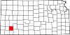
Townships Categories:- Townships in Haskell County, Kansas
- Kansas geography stubs


Wikimedia Foundation. 2010.