- Hopelchén (municipality)
Infobox Settlement
name = Hopelchén
settlement_type = Municipality
subdivision_type = Country
subdivision_name = flag|Mexico
subdivision_type1 = State
subdivision_name1 =Campeche
pushpin_
map_caption =
mapsize= 250px
population_as_of=2005
population_total=34687
population_note=
population_density_km2=auto
area_total_km2= 7460.27
leader_title =Municipal president
leader_name = Julio Alberto Sansores Sansores (2006-09)
leader_party =
subdivision_type2 = Municipal seat
subdivision_name2 =Hopelchén
subdivision_type3 =
subdivision_name3 =
blank_name = Spanish foundation
blank_info =1621
blank1_name = City status
blank1_info =26 February 1959
blank2_name =
blank2_info =
timezone = CST
utc_offset = -6
timezone_DST = CDT
utc_offset_DST = -5
latd =17 | latm =48 | lats = | latNS =N
longd = 89 | longm= 06 | longs= | longEW =W
website= [http://www.hopelchen.gob.mx/wb2/ www.hopelchen.gob.mx]
footnotes=Hopelchén (
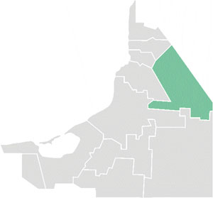
Yucatec Maya : "place of five wells") is one of the 11 municipalities in the Mexican state ofCampeche . It is situated inland in the north of the state. The municipal seat, and largest settlement, is the city ofHopelchén .History and geography
The municipality of Hopelchén is bordered to the north and east by the state of
Yucatán ; to the south by the municipality ofCalakmul , and to the west by the municipalities ofChampotón , Campeche,Tenabo andHecelchakán .It covers 7,460.27 km², accounting for 13% of the state's total surface area.
Demographics
The 2005 INEGI census reported a population of 34,687, down from 36,271 in 1990. Of the 1990 figure, 17,664 spoke one of several indigenous languages, predominantly
Yucatec Maya with 14,983 and Ch'ol with 2,039; the total number of indigenous language speakers had fallen to 15,416 by 2005.Population centres in the municipality include:
*Hopelchén , the municipal seat
*Bolonchen de Rejón (3,765 inhabitants)
*Dzibalchen (2,579)
*Ukum (1,585)Heritage
The Maya archaeological sites of
Chunan-Tunich ,Dzibilnocac ,Santa Rosa Xtampak ,Hochob andPak-Chén are located in the municipality. It is also home to two cave complexes:Chuncedro andXtacumbilxuna’an References
* [http://www.inegi.gob.mx/est/contenidos/espanol/sistemas/conteo2005/localidad/iter/ Link to tables of population data from Census of 2005] INEGI: Instituto Nacional de Estadística, Geografía e Informática
* [http://www.e-local.gob.mx/work/templates/enciclo/campeche/Mpios/04006a.htm Hopelchén] Enciclopedia de los Municipios de MéxicoExternal links
* [http://www.hopelchen.gob.mx/ Ayuntamiento de Hopelchén] Official website es icon
* [http://www.portal.camp.gob.mx/C15/Hopelchen/default.aspx Municipio de Hopelchén] from official Campeche state government website es icon

Wikimedia Foundation. 2010.