- 1924 Atlantic hurricane season
Infobox hurricane season | name=1924 Atlantic hurricane season
first storm formed=June 18 ,1924
last storm dissipated=Nov. 15, 1924
strongest storm=#2 - 115 knots (135 mph)
total storms=8
major storms=2
total daGBP )
total fatalities=≥150
basin=Atlantic hurricane
five seasons=1922, 1923, 1924, 1925, 1926 The 1924 Atlantic hurricane season ran through the summer and the first half of fall in 1924. The season was average with 8 storms; three became hurricanes and two became major hurricanes. An early season tropical storm hitBelize on June 18th andMexico onJune 21 . Two hurricanes formed in August and followed a similar path, forming in the tropical Atlantic, hitting theLesser Antilles , passing west ofBermuda , becoming extratropical, and eventually hittingNova Scotia .A hurricane also struck Florida in early September. A second tropical storm would also hit Florida later in the month. The most intense tropical cyclone of the season struck western Cuba as a major hurricane and eventually moved ashore near
Marco Island, Florida with weaker winds in October. A November tropical storm hitJamaica andCuba , becoming a hurricane over the western Atlantic Ocean. It is one of only eleven tropical cyclones to occur during November in the Atlantic hurricane database.torms
Tropical Storm One
Infobox Hurricane Small
Basin=Atl
Formed=June 18 ,1924
Dissipated=June 21 ,1924
1-min winds=40
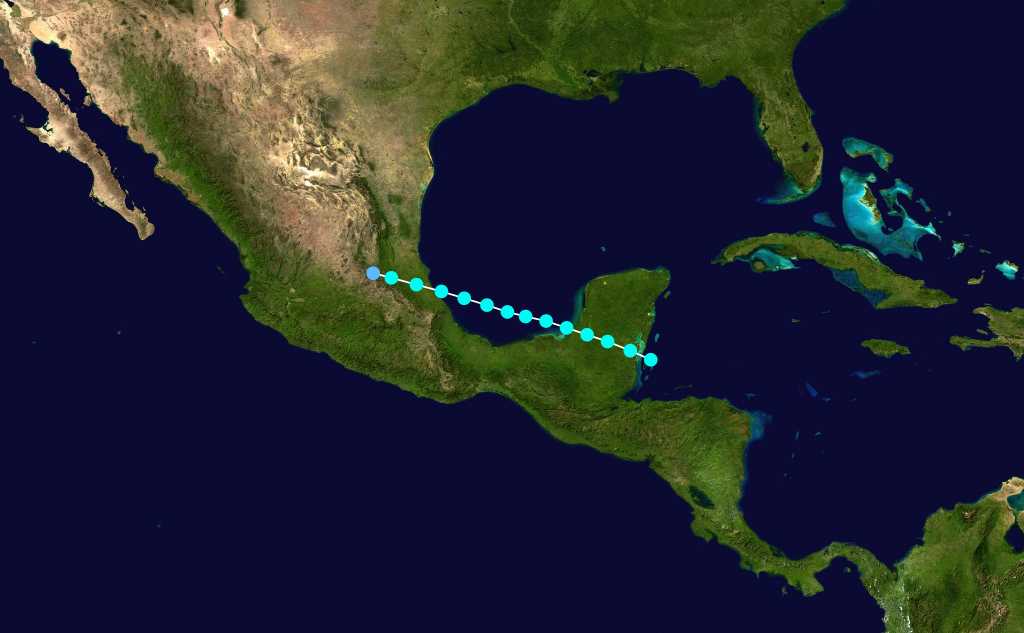
Pressure=A tropical storm was detected 75 miles (120 km) southeast ofChetumal onJune 18 . It made landfall on northernBelize with estimated winds near 45 mph (75 km/h). Pressures were progressively decreasing over the preceding days in the northwesternCaribbean Sea .cite web|url=http://www.aoml.noaa.gov/hrd/hurdat/mwr_pdf/1924.pdf|title=1924 Monthly Weather Review|publisher=U.S. Weather Bureau|accessdate=2008-03-15|format=PDF] The tropical system crossed theYucatán Peninsula , emerging over theBay of Campeche onJune 19 with 40 mph (65 km/h) winds.cite web|author=Hurricane Research Division|year=2008|url=http://www.aoml.noaa.gov/hrd/hurdat/tracks1851to2006_atl_reanal.txt|title=Atlantic hurricane best track|publisher=NOAA|accessdate=2008-03-15] It re-strengthened over water, and it re-attained winds of 45 mph (75 km/h). Early onJune 21 , it made landfall 115 miles (185 km) south ofTampico, Tamaulipas . It dissipated over land. The cyclone was classified as a weak disturbance, and strong winds were not recorded throughout the life span of the storm.Squall s affected the Texas coast, prompting advisories for small watercraft. Heavyrain fall was reported in Mexico.Hurricane Two
Infobox Hurricane Small
Basin=Atl
Formed=August 16 ,1924
Dissipated=August 28 ,1924
1-min winds=116
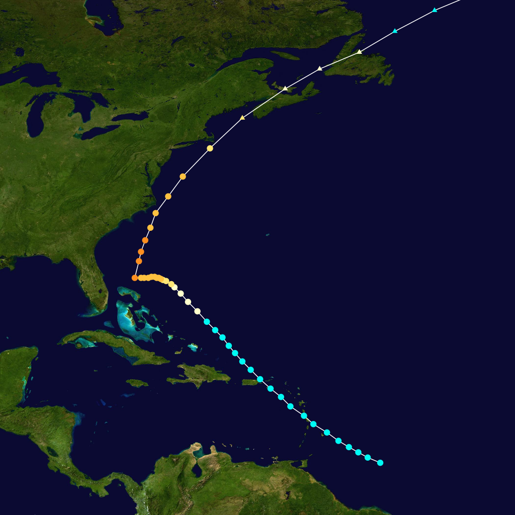
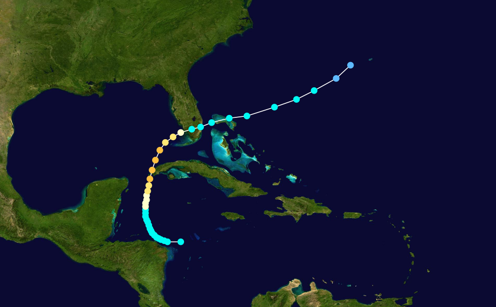
Pressure=The second tropical cyclone of the season formed 420 miles (675 km) southeast ofBridgetown, Barbados onAugust 16 . It moved northwest and crossed the eastern Caribbean as a minimal tropical storm onAugust 18 . OnAugust 19 , it passed east ofSan Juan, Puerto Rico and re-entered the Atlantic Ocean. OnAugust 20 , it quickly strengthened to the equivalent of a Category 1 hurricane on theSaffir-Simpson Hurricane Scale . The cyclone slowed and turned west onAugust 21 , and it continued to strengthen east of the northern Bahamas. The cyclone strengthened to a peak intensity of 135 mph (215 km/h) north ofGrand Bahama onAugust 24 . At the time, the storm was nearly stationary. Several ships reported winds of hurricane force, rough seas, andatmospheric pressure readings to 970 mbar (28.67 inHg) fromAugust 23 throughAugust 25 . The cyclone turned sharply north, remaining east of the East Coast. On August 25, it quickly weakened, and it passed close toCape Hatteras onAugust 26 . It transitioned to anextratropical cyclone , and it passed overNova Scotia onAugust 27 . The approach of the storm led to the issuance of storm warnings from Cape Hatteras toMiami, Florida onAugust 22 . Hurricane warnings extended fromBeaufort, North Carolina to Cape Henry. In advance of the storm, radio broadcasts also advised shipping interests to remain cautious north ofPuerto Rico . No damages occurred along the coast because of the recurving storm. Peak wind gusts reached 74 mph (120 km/h) atHatteras, North Carolina , and two people drowned along the coast.cite web|author=James E. Hudgins|year=2000|title=Tropical Cyclones Affecting North Carolina since 1566 – An Historical Perspective|publisher=Blacksburg, Virginia National Weather Service|accessdate=2008-03-18|url=http://web.archive.org/web/20070311045226/http://repository.wrclib.noaa.gov/cgi/viewcontent.cgi?article=1002&context=nws_tech_memos] Damage was minimal, though Ocracoke Island was flooded during the storm. The White Starpassenger liner SS|Arabic|1920|2 was battered by the storm onAugust 26 while the ship was off the Nantucket Shoals. The ship arrived in New York the following day with 75 injured after having what was reported as a "100-foot wave" crash over the liner. [cite news | title = Gale-lashed Arabic docks with 75 hurt; 4 other liners hit | date =1924-08-28 | work =The New York Times | page = 1 ]Hurricane Three
Infobox Hurricane Small
Basin=Atl
Formed=August 26 ,1924
Dissipated=September 4 ,1924
1-min winds=90
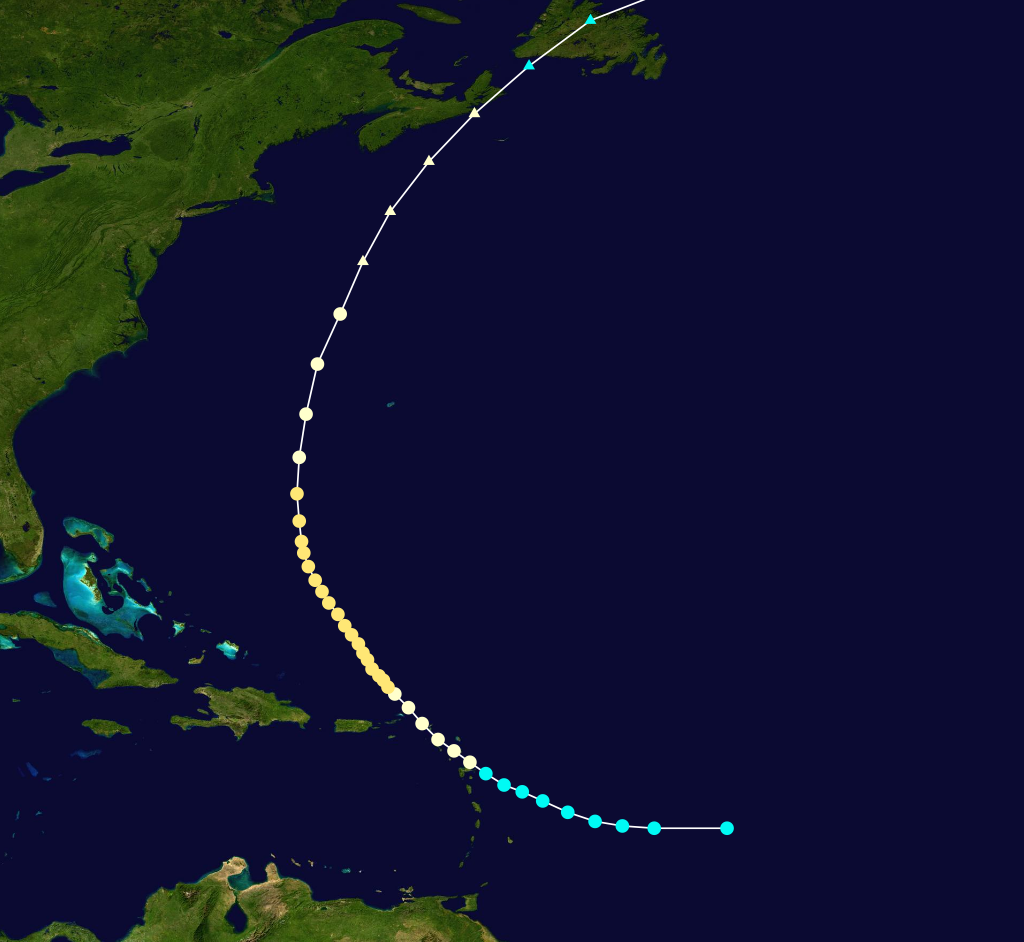
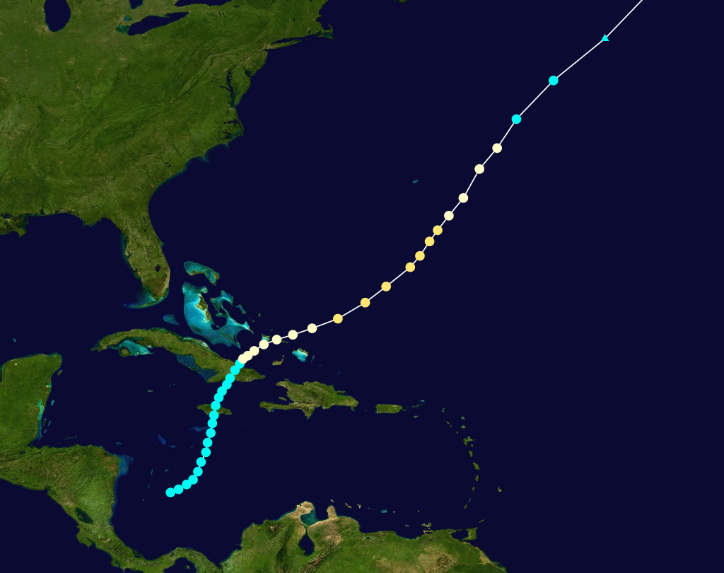
Pressure=965The third tropical storm of the season developed 800 miles (1,285 km) southeast ofBasse-Terre ,Guadeloupe onAugust 25 . Initially, it moved west onAugust 26 . OnAugust 27 , it turned west-northwest and intensified as it approached theLesser Antilles . It strengthened to a hurricane onAugust 28 , and it crossed Cudjoe Head on the island ofMontserrat . A minimum pressure of 965 mbar (28.50 inHg) was recorded. The cyclone turned northwest, crossing the northeastern Caribbean nearAnguilla onAugust 29 . The hurricane continued to intensify over the western Atlantic Ocean, and it reached peak winds of 105 mph (170 km/h) when it was located 755 miles (1,215 km) south-southeast ofBermuda onAugust 30 . The cyclone recurved northward onSeptember 2 , and it weakened to the equivalent of a Category 1 hurricane onSeptember 3 . OnSeptember 4 , it lost tropical characteristics, though it retained hurricane force winds when it struck Nova Scotia onSeptember 5 . In the Virgin Islands, the cyclone destroyed hundreds of homes and severely damaged crops. Several deaths were reported. Heavy precipitation caused flooding on several islands in the path of the storm. OnSaint Thomas , small boats were wrecked and trees were uprooted by the winds.cite web|author=The Daily Gleaner|year=1924|url=http://www.thehurricanearchive.com/Viewer.aspx?|title=New Storm Hard on Heels of its Predecessor|accessdate=2008-03-15] More than 6,000 people were homeless on Montserrat, while 30 were dead and 200 received wounds. Damages were estimated near £100,000 on the island.cite web|author=The Daily Gleaner|year=1924|url=http://www.thehurricanearchive.com/Viewer.aspx?
|title=Fund Opened to Aid Sufferers by Hurricane|accessdate=2008-03-15] The Red Cross donated $3,000 and fed victims after the storm.cite web|author=The Bridgeport Telegram|year=1924|url=http://www.thehurricanearchive.com/Viewer.aspx?
|title=Red Cross Feeds Homeless Victims After Hurricane|accessdate=2008-03-15] In total, damages reached £86,000 and at least 59 people were killed in the
Leeward Islands .Hurricane Four
Infobox Hurricane Small
Basin=Atl
Formed=September 13 ,1924
Dissipated=September 19 ,1924
1-min winds=70
Pressure=OnSeptember 12 , a strong tropical storm developed 85 miles (135 km) southwest ofKey West, Florida . It moved northwest, quickly strengthening to a hurricane onSeptember 13 . Later, the storm attainedmaximum sustained wind s of 80 mph (130 km/h). Late onSeptember 14 , the cyclone turned northeast, and it struck theFlorida Panhandle nearPort St. Joe, Florida onSeptember 15 . The minimum pressure measured in northwest Florida was 985 mbar (29.10 inHg) at Carrabelle. The hurricane quickly weakened to a tropical storm as it moved inland, crossing southern Georgia onSeptember 16 . It entered the Atlantic Ocean nearSavannah, Georgia with winds near 45 mph (75 km/h). It accelerated east-northeast, becoming extratropical off Cape Hatteras onSeptember 17 . The system was last detected onSeptember 19 south of Newfoundland. In Florida, the hurricane caused minor damage to properties, and peak gusts reached 75–80 mph (120–130 km/h) in Port St. Joe. In the vicinity of Port St. Joe, two fishing vessels were blown ashore during the storm, while a schooner was wrecked near Carrabelle. Advance warnings reduced the potential damages in northwest Florida. In Georgia, heavy precipitation caused two deaths and significant crop damage. Most ofBrownton, Georgia was destroyed by floods.cite web|author=The Chronicle-Telegram|year=1924|url=http://www.thehurricanearchive.com/Viewer.aspx?|title=Hurricane Hits Georgia Towns|accessdate=2008-03-15] Gale force winds also occurred along the
Eastern Seaboard , though warnings were released in advance of the winds. Operationally, the cyclone was not believed to have attained hurricane intensity.Tropical Storm Five
Infobox Hurricane Small
Basin=Atl
Formed=September 27 ,1924
Dissipated=September 30 ,1924
1-min winds=50
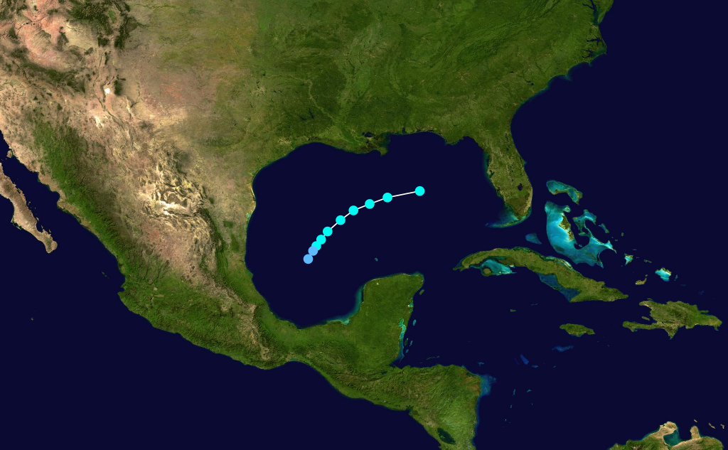
Pressure=Low pressures were reported in the northwestern Caribbean Sea fromSeptember 23 throughSeptember 27 . On the latter day, a minimal tropical storm formed over the southwestern Caribbean Sea east ofRoatán ,Honduras . Operationally, ships did not detect a low-level circulation. OnSeptember 28 , the cyclone moved northward and slowly intensified, passing east ofCozumel . OnSeptember 29 , it entered the southernGulf of Mexico , attaining its maximum sustained winds of 50 mph (85 km/h) as a tropical system. It quickly accelerated northeast and transitioned to an extratropical system with 60 mph (95 km/h) winds. Later, it entered the Big Bend of Florida near Cedar Key. On September 30, it rapidly moved northeast across the coastal Southeastern United States. It was last detected nearNorfolk, Virginia . On September 29, storm warnings were released for the eastern Gulf Coast, advising residents to prepare for gale force winds. Warnings were also issued fromJacksonville, Florida toFort Monroe, Virginia . Eventually, warnings also encompassed the Mid-Atlantic andNortheastern United States , and gale force winds affected the Eastern Seaboard.Tropical Storm Six
Infobox Hurricane Small
Basin=Atl
Formed=October 12 ,1924
Dissipated=October 14 ,1924
1-min winds=50
Pressure=Early onOctober 12 , the sixth tropical cyclone of the season developed in the easternGulf of Mexico 280 miles (450 km) southwest ofSaint Petersburg, Florida . At the time, the storm was estimated to have attained its maximum intensity of 60 mph (95 km/h). It moved quickly southwest, and it weakened to a minimal tropical storm onOctober 13 . OnOctober 14 , the system weakened to a tropical depression and dissipated over the southwestern Gulf of Mexico. Operationally, the system was classified as a moderate disturbance.cite web|author=The Port Arthur News|year=1924|url=http://www.thehurricanearchive.com/Viewer.aspx?|title=Short Stories|accessdate=2008-03-18]
Hurricane Seven
Infobox Hurricane Small
Basin=Atl
Formed=October 14 ,1924
Dissipated=October 23 ,1924
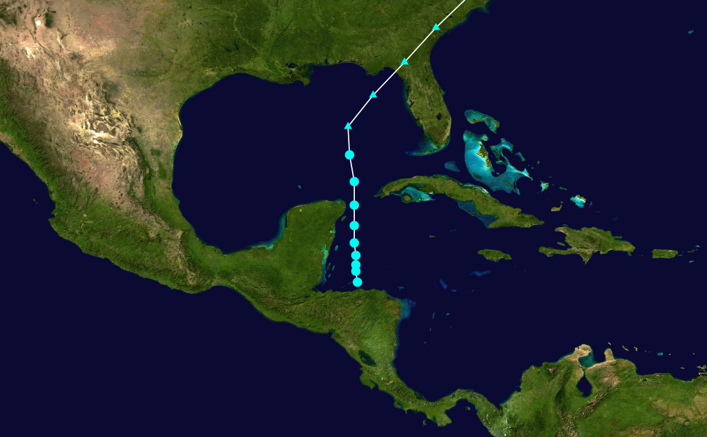
1-min winds=105
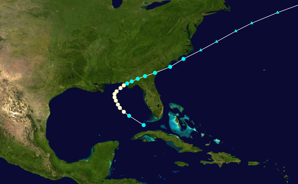
Pressure=922Late onOctober 13 , a minimal tropical storm formed in the western Caribbean Sea east-northeast of northern Honduras. At the time, it was first detected when atmospheric pressures decreased over the Swan Islands onOctober 14 . It moved slowly west-northwest, and it gradually turned north onOctober 15 . Late on October 15, it steadily intensified, and it attained hurricane intensity onOctober 17 . OnOctober 19 , it strengthened to the equivalent of a major hurricane, and it struck thePinar del Río Province ofCuba with sustained winds of at least 120 mph (195 km/h). A ship reported a minimum central pressure of 922 mbar (27.23 inHg) nearCayo Jutías ,cite web|author=Partagas, Jose Fernandez|year=1993|url=http://www.aoml.noaa.gov/hrd/Landsea/Partagas/impacthurrhist.pdf|title=Impact on Hurricane History of a Revised Lowest Pressure at Havana (Cuba) During the October 11, 1846 Hurricane|publisher=NOAA|accessdate=2008-03-18|format=PDF] suggesting that the cyclone may have been stronger. OnOctober 20 , the hurricane turned east-northeast in response to the southward movement of a ridge, and it quickly weakened. Early onOctober 21 , it struckSouthwest Florida near Naples,Florida as a Category 1 hurricane,cite web|author=Blake, Rappaport, and Landsea|year=2006|title=The Deadliest, Costliest, and Most Intense United States Tropical Cyclones (1851 to 2006)|publisher=NOAA|accessdate=2008-03-18|url=http://www.nhc.noaa.gov/pdf/NWS-TPC-5.pdf] and it entered theAtlantic Ocean north of Miami with 70 mph (110 km/h) winds. The cyclone steadily weakened as it moved across the western Atlantic Ocean, and it dissipated west-southwest ofBermuda onOctober 23 .In Cuba, at least 90 people were killed.cite web|url=http://www.cubahurricanes.org/history-hurricanes-chronicles.php|title=Cuba Hurricanes Historic Threats|publisher=CubaHurricanes.org|accessdate=2008-03-18] The hurricane produced severe damage to crops and buildings across western Cuba, injuring 50–100 people in Arroyos de Mantua.cite web|author=The Associated Press|year=1924|url=http://www.thehurricanearchive.com/Viewer.aspx?
|title=12 Killed, 100 Hurt in Hurricane in Florida|publisher=Oakland Tribune|accessdate=2008-03-18] In Key West, peak gusts reached 66 mph (105 km/h) and damage was minimal to vegetation. In advance, watercraft were secured and trees were trimmed, reducing damages during the storm. The hurricane produced heavy precipitation across southern Florida, peaking at 23.22 inches (590 mm) on Marco Island.Barnes, Jay (1998). "Florida's Hurricane History." Page 108.] The rains caused flooding in Palm Beach County, disrupting traffic on highways and railroads.cite web|author=The Associated Press|year=1924|url=http://www.thehurricanearchive.com/Viewer.aspx?
|title=Gulf Tornado Takes 13 Lives-50 are Injured|publisher=The San Antonio Express|accessdate=2008-03-18] The measured totals of 11.21 inches (112 mm) were believed to have been the highest rainfall in the county over the past 15 years. Peak gusts reached 68 mph (110 km/h) across the mainland of southern Florida, while sailing trips from southeastern Florida were cancelled. Telegraph wires were disabled in Fort Myers and Punta Gorda, though damages were minimal.
Hurricane Eight
Infobox Hurricane Small
Basin=Atl
Formed=November 5 ,1924
Dissipated=November 15 ,1924
1-min winds=85
Pressure=Early onNovember 5 , a tropical storm formed in the southernCaribbean 275 miles (445 km) north-northwest ofPanama City ,Panama . Operationally, the cyclone was not detected untilNovember 8 , when observations indicated the presence of a circulation nearJamaica . The system moved northward with winds of minimal intensity, and it struckClarendon Parish, Jamaica onNovember 7 with 40 mph (65 km/h) sustained winds. Early on November 8, it left the northern coast of the island, and it strengthened prior to making landfall west ofSantiago de Cuba onNovember 9 . Later, the cyclone strengthened to a hurricane as it entered the Atlantic Ocean, and it turned northeast over theTurks and Caicos Islands onNovember 10 . A ship reported hurricane force winds and a pressure of 996 mbar (29.40 inHg) near the center. OnNovember 11 , the hurricane accelerated as it left the Turks and Caicos Islands, and it attained a peak intensity of 100 mph (155 km/h). It maintained Category 2 status untilNovember 13 . The system weakened and passed east ofBermuda , and it diminished to a tropical storm onNovember 14 . It quickly became extratropical, and it was last reported onNovember 15 .References
See also
*
List of tropical cyclones
*List of Atlantic hurricane seasons References
*ONLY 4 ARE KILLED ON VIRGIN ISLANDS. The Atlanta Constitution. Atlanta, Ga.: Sep 4, 1924. pg. 6, 1 pgs
External links
* [http://www.aoml.noaa.gov/general/lib/lib1/nhclib/mwreviews/1924.pdf Monthly Weather Review]
* [http://weather.unisys.com/hurricane/atlantic/1924/index.html Unisys tracking data for 1924]
* [http://www.aoml.noaa.gov/hrd/Landsea/deadly/Table3A.htm]

Wikimedia Foundation. 2010.