- 1922 Atlantic hurricane season
Infobox hurricane season | name=1922 Atlantic hurricane season
first storm formed=June 12, 1922
last storm dissipated=Oct. 22, 1922
strongest storm=#2 - 120 knots (140 mph)
total storms=4
major storms=1
total da
total fatalities=None
basin=Atlantic hurricane
five seasons=1920, 1921, 1922, 1923, 1924 The 1922 Atlantic hurricane season ran through the summer and the first half of fall in 1922. The season was a quiet one, with only four tropical cyclones forming during the course of the season. The first was atropical storm that passed over theYucatán Peninsula and later made another landfall in rural northeastMexico . The second was ahurricane , the strongest one of the season. It formed nearCape Verde and curved out into theAtlantic . It grazed theLeeward Islands and batteredBermuda , passing just offshore as aCategory 4 . The hurricane becameextratropical soon after it passed Bermuda. The third was a tropical storm that passed overCuba and made landfall nearPensacola, Florida . The last storm of the season was a Category 2 hurricane that made landfall near Cancún, Mexico. The hurricane weakened in theBay of Campeche and dissipated just offshore.torms
Tropical Storm One
infobox Hurricane Small
Basin=Atl
Formed=June 12
Dissipated=June 16
1-min winds=45
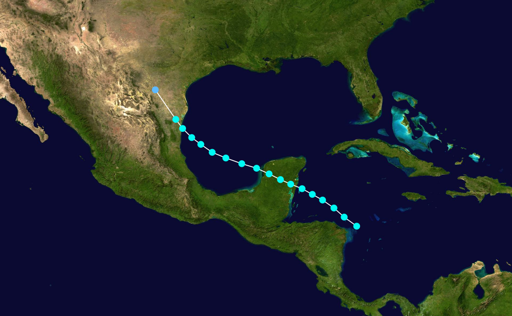
pressure=UnknownThe first storm of the season formed off Cabo Gracias, Nicaragua on June 12 and moved generally northwestward. The storm strengthened very little before hitting the centralYucatan Peninsula . Once it emerged into theGulf of Mexico , it began to grow in intensity. TheMonthly Weather Review says the storm resembled a developing hurricane. According to the Best Track data, however, winds never exceeded 50 mph. Landfall in mainland Mexico stopped the intensification. It came ashore in a sparsely populated area near the village of La Pesca, about 150 miles south of the mouth of theRio Grande . The storm brought very heavy rain to the Rio Grande Valley that caused significant flooding, but no fatalities were reported.Hurricane Two
Infobox Hurricane Small
Basin=Atl
Formed=September 13
Dissipated=September 26
1-min winds=130
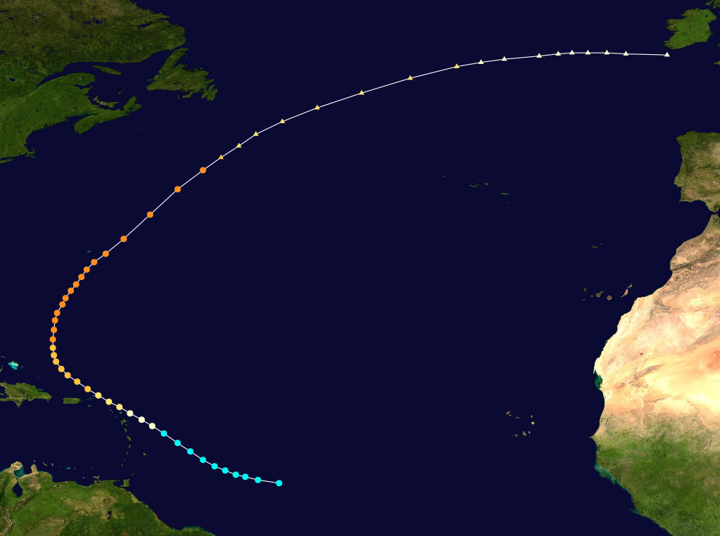
Pressure=≤967 By far the most powerful storm of the season, this hurricane formed well east of theWindward Islands and moved northwestward steadily strengthening. It grazed theLeeward Islands as a Category 2 hurricane and began to recurve shortly thereafter. During this recurvature, it strengthened into a Category 4 storm, eventually attaining winds of 150 mph. It would maintain Category 4 intensity for the next four days until it became extratropical on September 22. The storm passed almost directly overBermuda early on September 21, buffeting the island with 120 mph winds and an eight-footstorm surge . As the center of this hurricane passedBermuda to the southeast, a lull occurred on the island for an hour around 9 am on September 21. The lowest pressure measured was 968 mbar (28.57 inHg). Significant damage occurred there, as winds peaked at 120 mph. It was Bermuda's highest tide since the hurricane of 1899.Tucker, Terry (1966). "Beware the Hurricane!" Hamilton Press.] The hurricane remains the strongest Atlantic tropical cyclone above 30.4°N, since Hurricane Dog of 1950 weakened to below 150 mph (240 km/h) as it reached that latitude.cite web|author=Hurricane Research Division|year=2008|title=Atlantic hurricane best track|publisher=NOAA |accessdate=2008-04-06|url=http://www.aoml.noaa.gov/hrd/hurdat/tracks1851to2007-mar08.html]Tropical Storm Three
Infobox Hurricane Small
Basin=Atl

Formed=October 12
Dissipated=October 17
1-min winds=45
pressure=UnknownStorm Three formed of the northern coast of Honduras on October 12 and turned northwestward. The storm strengthened very little during its lifetime, striking western Cuba with only 45 mph sustained winds. It reached its peak intensity of 50 mph in the Gulf of Mexico. It held this intensity for two days, weakening just before landfall nearOrange Beach, Alabama . The storm dissipated quickly inland.Hurricane Four
Infobox Hurricane Small
Basin=Atl
Formed=October 14
Dissipated=October 22
1-min winds=85
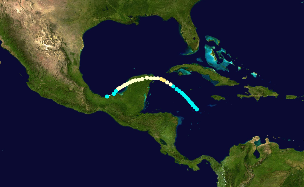
Pressure=≤984 Early on October 12, alow pressure area was detected by the S.S. "Chalmette" in the westernCaribbean Sea ,cite web|url=http://www.aoml.noaa.gov/general/lib/lib1/nhclib/mwreviews/1922.pdf|title=1922 Monthly Weather Review|publisher=U.S. Weather Bureau|accessdate=2008-04-28|format=PDF] and the system is believed to have organized to a minimal tropical storm 260 miles (420 km) southwest ofKingston, Jamaica late on October 13. The cyclone slowly moved northwest, and it gradually intensified on October 15. On the evening of October 16, the tropical storm rapidly intensified, and it strengthened to the equivalent of a minimal hurricane on October 17. Later, it attained peak sustained winds of 100 mph (155 km/h). Early on October 18, a ship reported a minimum pressure of 984 mbar (29.06 inHg) near the center, which was the lowest pressure measured during the life span of the storm. Subsequently, the hurricane weakened, and it made landfall 10 miles (16 km) south of Cancún with winds of 80 mph (130 km/h). It crossed the peninsula and moved south along the coast, weakening to a minimal tropical storm and striking theTabasco area. The storm caused significant property damage and shipping losses. Several fishing vessels sank and some ocean liners (including the now-infamous Morro Castle) were stranded outside Vera Cruz harbor because violent seas made it too dangerous to enter. There were a few fatalities in the Yucatan, where damage to buildings and crops was severe.ee also
*
List of tropical cyclones
*List of Atlantic hurricane seasons References
Printed media
*Terry Tucker. Beware the Hurricane! Hamilton Press: Bermuda, 1966.
External links
* [http://www.aoml.noaa.gov/general/lib/lib1/nhclib/mwreviews/1922.pdf Monthly Weather Review]

Wikimedia Foundation. 2010.