- Missillac
-
Missillac
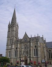
L'église Saint-Pierre-et-Saint-Paul. 
 MissillacLocation within Pays de la Loire region
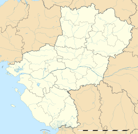 Missillac
Administration Country France Region Pays de la Loire Department Loire-Atlantique Arrondissement Saint-Nazaire Canton Saint-Gildas-des-Bois Intercommunality Pays de Pont-Château - Saint-Gildas-des-Bois Mayor Bernard Lelièvre
(2008–2014)Statistics Elevation 0–63 m (0–207 ft) Land area1 59.55 km2 (22.99 sq mi) Population2 4,474 (2006) - Density 75 /km2 (190 /sq mi) INSEE/Postal code 44098/ 44780 Website www.cc-paysdepontchateau.fr 1 French Land Register data, which excludes lakes, ponds, glaciers > 1 km² (0.386 sq mi or 247 acres) and river estuaries. 2 Population without double counting: residents of multiple communes (e.g., students and military personnel) only counted once. Coordinates: 47°28′59″N 2°09′28″W / 47.4830555556°N 2.15777777778°W
Missillac (Merzhelieg in Breton) is a commune located in the department of Loire-Atlantique in western France.
Geography
Missillac is located at the North-Western edge of Loire-Atlantique at the limit of the Morbihan. 25 km of Saint-Nazaire, 65 kmNorth-West of Nantes and 25 km south of Redon. The villages or communes bordering Missillac are Séverac, Saint-Gildas-des-Bois, Sainte-Reine-de-Bretagne, La Chapelle-des-Marais, Herbignac, Pontchâteau. According to the established ranking by INSEE in 1999, Missillac is a rural district which belongs to Saint-Nazaire. Missillac belongs to the traditional country of Brière. The commune is crossed by the expressway Nantes-Vannes.
See also
- La Baule - Guérande Peninsula
- Communes of the Loire-Atlantique department
- Parc naturel régional de Brière
Categories:- Communes of Loire-Atlantique
- Loire-Atlantique geography stubs


Wikimedia Foundation. 2010.