- Ok Tedi River
-
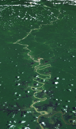
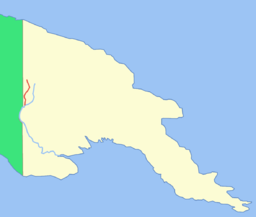
Ok Tedi River Satellite image of the Ok Tedi RiverCountries Papua New Guinea, Indonesia Region Western Province Tributaries - left Ok Menga, Ok Ma Source - location Star Mountains, Papua New Guinea - elevation 1,619 m (5,312 ft) - coordinates 5°5′24″S 141°13′5″E / 5.09°S 141.21806°E Mouth - location Fly, Papua New Guinea - elevation 22 m (72 ft) - coordinates 6°10′5″S 141°7′8.5″E / 6.16806°S 141.119028°E The Ok Tedi is a river in New Guinea. The Ok Tedi Mine is located near the headwaters of the river, which is sourced in the Star Mountains. Nearly the entirety of the river runs through the North Fly District of the Western Province of Papua New Guinea, but the river crosses the international boundary with Indonesia for less than one kilometre. The largest settlement of the Western Province, Tabubil is located near its banks.
Contents
Description
Known as the Ok Tedi River by the Yonggom people who live on its western bank, it was renamed the Alice River by the Italian explorer Luigi d'Albertis. Ok is the word for water or river in the Ok languages family. It is a tributary of the Fly River. Tributaries of the Ok Teri include the Birim.
The Kiunga-Tabubil Highway runs parallel with the river for the majority of its course, until just south of Ningerum where the highway veers southeast towards Kiunga, a port town on the Fly River.
The river is extremely fast-moving and has a massive capacity. It is situated on a sand bank, which allows for the river to change course quickly without warning. The sand conditions underneath the river and the extremely high rainfall of the catchment area make it one of the fastest moving rivers in the world. The roar from the river can be heard for many kilometres through the dense jungle of the district.
The river was in the world spotlight for a short period of time during the late 20th century, due to litigation from villagers on the Ok Tedi and Fly rivers downstream from the Ok Tedi Mine. These villagers claimed tailings waste from the mine introduced to the river system was affecting their livelihood. The case was settled out of court. Negotiations have continued on the cleanup of pollution from the mine, which is scheduled to close in 2013.[1]
See also
Notes
- ^ Peter S. Adler, Janesse Brewer, and Caelan McGee (2007-07-24). "The Ok Tedi Negotiations". The Keystone Center. Archived from the original on 2007-10-14. http://web.archive.org/web/20071014234954/http://keystone.org/spp/documents/FINALOk+Tedi+Negotiations-TKC-08-24-07.pdf. Retrieved 2007-09-26.
External links
Categories:- Rivers of Papua New Guinea
- Western Province (Papua New Guinea)
- Fly River
- International rivers of Asia
- International rivers of Oceania
- Rivers of West Papua
- Papua New Guinea geography stubs
Wikimedia Foundation. 2010.


