- Baqa ash-Sharqiyya
-
Baqa ash-Sharqiyya Other transcription(s) – Arabic باقه الشرقية – Also spelled Baqa al-Sharqiyya (official)
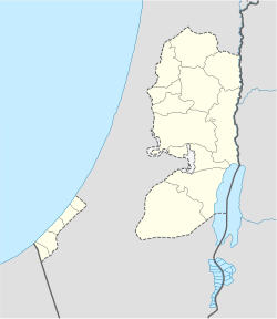
Baqa ash-Sharkiya (unofficial)Location of Baqa ash-Sharqiyya within the Palestinian territories Coordinates: 32°24′38.10″N 35°04′08.91″E / 32.410583°N 35.0691417°ECoordinates: 32°24′38.10″N 35°04′08.91″E / 32.410583°N 35.0691417°E Governorate Tulkarm Government – Type Municipality – Head of Municipality Muaiad Abd al-Rahman Hussein Area – Jurisdiction 4,211 dunams (4.2 km2 / 1.6 sq mi) Population (2006) – Jurisdiction 4,300 Name meaning "The eastern bouquet [of flowers]" Baqa ash-Sharqiyya (Arabic: باقه الشرقية) is a Palestinian town in the northern West Bank, located 16 kilometers (9.9 mi) northeast of Tulkarm in the Tulkarm Governorate. According to the Palestinian Central Bureau of Statistics (PCBS), the town had a population of approximately 4,300 inhabitants in mid-year 2006;[1] refugees made up 20.4% of the Baqa ash-Sharqiyya's population in 1997.[2]
Approximately 3 kilometers (1.9 mi) to the west, on the other side of the Green Line, lies Baqa al-Gharbiyye, ("the western bouquet of flowers") which is under Israeli jurisdiction. Both towns were originally one town, known as Baqa, until the aftermath of the 1948 Arab-Israeli War. Prior to the Second Intifada, Baqa ash-Sharqiyya consisted of 4,000 dunams; Israel confiscated about 2,000 dunams of land in order to build the Israeli West Bank barrier.[3]
Contents
History
Baqa ash-Sharqiyya is situated at an ancient site. The Survey of Western Palestine described Baqa as "a very small hamlet on high ground, with olives. It has a well to the south and a little Mukam (Muslim tomb) to the north; scattered olives surround it, and there are two or three palms close by." A stone with Arabic inscriptions located over the entrance of the old village mosque could be the beginning of an endowment (waqf) text.[4][5]
As part of the 1949 armistice agreements following the 1948 Arab-Israeli war, King Abdullah of Jordan ceded the captured Wadi Ara region to Israel in exchange for land near Hebron. This resulted in Baqa ash-Sharqiyya falling on the western side of the Green Line, separated from its eastern counterpart, Baqa ash Sharqiyya. The separated towns still have close social and economic ties, however this has been reduced due to the completion of the West Bank barrier around the "Baqa enclave" of the Seam Zone.[6]
Health care
Baqa ash-Sharqiyya houses the Mother and Child Health Centre (MCH), which is used by the three surrounding Palestinian villages (Nazlat Abu Nar and An-Nazla al-Gharbiya).[7] The healthcare facilities for Baqa ash-Sharqiyya are designated as MOH level 3.[8]
References
- ^ Projected Mid -Year Population for Tulkarm Governorate by Locality 2004- 2006 Palestinian Central Bureau of Statistics
- ^ Palestinian Population by Locality and Refugee Status Palestinian Central Bureau of Statistics
- ^ Baqa Al Sharqia: A Palestinian village isolated by the Segregation Wall Land Research Center. 13 August 2003.
- ^ Sharon, 1999, p.88.
- ^ SWP, 1881, vol 2, p.152
- ^ Profile: Baqa Sharqiya Enclave & Qafin UNRWA
- ^ Trapped by the Barrier: Life in a Palestinian Enclave UNRWA
- ^ Health care Facilities Tulkarm Governorate
Bibliography
- Conder, Claude Reignier and H.H. Kitchener (1881): The Survey of Western Palestine: memoirs of the topography, orography, hydrography, and archaeology. London:Committee of the Palestine Exploration Fund. vol 2
- Sharon, Moshe (1999), Corpus Inscriptionum Arabicarum Palaestinae, Vol. II, B-C, BRILL, ISBN 9004110836, http://books.google.com/?id=EPFDU8POrXIC
Cities 

Municipalities Anabta · Attil · Bal'a · Baqa ash-Sharqiyya · Beit Lid · Deir al-Ghusun · Dhinnaba · 'Illar · Kafr al-Labad · Qaffin · ZeitaVillages Far'un · Iktaba · Izbat Shufa · Al Jarushiya · Kafr Abbush · Kafr Jammal · Kafr Rumman · Kafr Sur · Kafr Zibad · Khureish · Kur · an-Nazla al-Gharbiya · an-Nazla ash-Sharqiya · an-Nazla al-Wusta · Nazlat Abu Nar · Nazlat 'Isa · Raml Zeita · Ramin · al-Ras · Saffarin · Seida · ShufaRefugee camps Categories:- Tulkarm Governorate
- Towns in the West Bank
Wikimedia Foundation. 2010.

