- Troutdale, Oregon
Infobox Settlement
official_name = Troutdale, Oregon
settlement_type =City
nickname =
motto =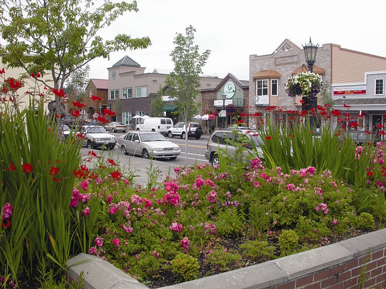
imagesize = 250px
image_caption = Downtown Troutdale
image_
image_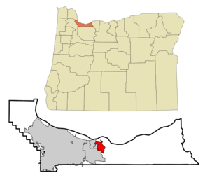
mapsize = 250px
map_caption = Location inOregon
mapsize1 =
map_caption1 =
subdivision_type = Country
subdivision_name =United States
subdivision_type1 = State
subdivision_name1 =Oregon
subdivision_type2 = County
subdivision_name2 = Multnomah
government_type =
leader_title =Mayor
leader_name = Paul Thalhofer
established_title = Incorporated
established_date = 1907
area_magnitude =
area_total_sq_mi = 5.0
area_total_km2 = 12.9
area_land_sq_mi = 5.0
area_land_km2 = 12.9
area_water_sq_mi = 0
area_water_km2 = 0
area_urban_sq_mi =
area_urban_km2 =
area_metro_sq_mi =
area_metro_km2 =
population_as_of = 2000
population_note =
population_total = 13777
population_metro =
population_urban =
population_density_km2 = 1066.0
population_density_sq_mi = 2761.1
timezone = Pacific
utc_offset = -8
timezone_DST = Pacific
utc_offset_DST = -7
latd = 45 |latm = 31 |lats = 46 |latNS = N
longd = 122 |longm = 23 |longs = 30 |longEW = W
elevation_m = 9.1–61.0
elevation_ft = 30–200
website = [http://www.troutdale.info http://www.troutdale.info]
postal_code_type =ZIP code
postal_code = 97060
area_code = 503
blank_name = FIPS code
blank_info = 41-74850GR|2
blank1_name = GNIS feature ID
blank1_info = 1128248GR|3
footnotes =Troutdale is a city in Multnomah County,
Oregon , north of Gresham and east of Wood Village. As of the 2000 census, the city population was 13,777.Troutdale was incorporated on
October 2 1907 . It was named after the country home of Captain John Harlow, a former sea captain fromMaine , and a successful Portland businessman. According to an article in the "Oregonian" in 1959, he named his home Troutdale because it had a "small dale near his house where it had a fish pond which he stocked with trout."The city serves as the eastern gateway to the
Historic Columbia River Highway , theMount Hood Scenic Byway , and theColumbia River Gorge .Geography
Troutdale is located at coor dms|45|31|46|N|122|23|30|W|city (45.529551, -122.391569)GR|1, bordering the confluence of the Sandy River and the
Columbia River .According to the
United States Census Bureau , the city has a total area of 5.0 square miles (12.9 km²), none of which is covered with water.Demographics
As of the
census GR|2 of 2000, there were 13,777 people, 4,671 households, and 3,690 families residing in the city. Thepopulation density was 2,761.1 people per square mile (1,066.0/km²). There were 4,865 housing units at an average density of 975.0/sq mi (376.4/km²). The racial makeup of the city was 87.54% White, 4.14% Asian, 1.90% African American, 0.92% Native American, 0.25% Pacific Islander, 1.71% from other races, and 3.53% from two or more races. Hispanic or Latino of any race were 4.62% of the population.There were 4,671 households out of which 44.3% had children under the age of 18 living with them, 64.6% were married couples living together, 10.8% had a female householder with no husband present, and 21.0% were non-families. 13.9% of all households were made up of individuals and 1.9% had someone living alone who was 65 years of age or older. The average household size was 2.89 and the average family size was 3.19.
In the city the population was spread out with 30.1% under the age of 18, 9.0% from 18 to 24, 35.4% from 25 to 44, 21.1% from 45 to 64, and 4.4% who were 65 years of age or older. The median age was 32 years. For every 100 females there were 100.4 males. For every 100 females age 18 and over, there were 99.4 males.
The median income for a household in the city was $56,593, and the median income for a family was $62,203. Males had a median income of $41,808 versus $30,989 for females. The
per capita income for the city was $21,778. About 3.3% of families and 4.8% of the population were below thepoverty line , including 4.2% of those under age 18 and 6.0% of those age 65 or over.History
The area was first "discovered" by Lt. Broughton under the command of Captain
George Vancouver in 1792. They had named Broughton's Bluff which is an outcropping directly across the Sandy River from what is now downtown Troutdale.Fact|date=September 2007The earliest settlers came to Troutdale in 1850.
David F. Buxton is considered to be Troutdale's true founder. He had made land claims and donated his land in 1853 in what is now the center of Troutdale. CaptainJohn Harlow purchased part of Buxton's land in 1872 and built a home and some trout farms, he named this farm "Troutdale". OnNovember 20 ,1882 , a rail line was built through the town. After Harlow's death in 1883, his widow Celestia began platting a town with blocks and streets. Much of the city was built in 1890-91.The City of Troutdale held a centennial celebration on
October 6 2007 .Local attractions
The
Troutdale Airport serves as a base for scenic aerial tours of theColumbia River Gorge . In addition to the Gorge, the town is home to over a dozen parks. It is also the location of one of the most notable locations of the localMcMenamins chain, the 38-acre (154,000 m²) Edgefield.Troutdale also has a variety of
factory outlet stores, a historic downtown district, and an expansivetruck stop row all within walking distance of each other. The presence of truck stops makes traveler information available almost 24 hours a day on Citizen's Band Channel 19.References
External links
* [http://www.ci.troutdale.or.us/ The city of Troutdale] , with additional history, as well as a collection of maps
* [http://troutdalechamber.org/ Troutdale Chamber of Commerce]
* [http://bluebook.state.or.us/local/cities/sy/troutdale.htm Oregon Blue Book entry on Troutdale]
Wikimedia Foundation. 2010.