- Menet
-
Menet

Administration Country France Region Auvergne Department Cantal Arrondissement Mauriac Canton Riom-ès-Montagnes Intercommunality Pays de Gentiane Mayor Alexis Monier
(2008–2014)Statistics Elevation 579–980 m (1,900–3,220 ft)
(avg. 715 m/2,346 ft)Land area1 29.86 km2 (11.53 sq mi) Population2 506 (2008) - Density 17 /km2 (44 /sq mi) INSEE/Postal code 15124/ 15400 1 French Land Register data, which excludes lakes, ponds, glaciers > 1 km² (0.386 sq mi or 247 acres) and river estuaries. 2 Population without double counting: residents of multiple communes (e.g., students and military personnel) only counted once. Coordinates: 45°17′51″N 2°35′03″E / 45.2975°N 2.58416666667°E
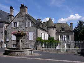
Menet is a commune in the Cantal department in south-central France.
The village is noteworthy for its twelfth century Romanesque Church of St Peter, and for its small lake.
Population
Historical population of Menet 1962 1968 1975 1982 1990 1999 2008 851 819 653 653 622 580 506 See also
References
Categories:- Communes of Cantal
- Cantal geography stubs
Wikimedia Foundation. 2010.

