- Chloe, West Virginia
-
- For other uses of this name or title, see Chloe (disambiguation).
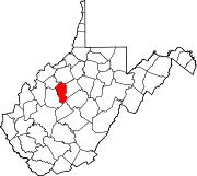
Chloe — Unincorporated community — Location within the state of West Virginia Coordinates: 38°41′33″N 81°5′11″W / 38.6925°N 81.08639°WCoordinates: 38°41′33″N 81°5′11″W / 38.6925°N 81.08639°W Country United States State West Virginia County Calhoun Time zone Eastern (EST) (UTC-5) - Summer (DST) EDT (UTC-4) ZIP codes 25235 FIPS code GNIS feature ID Chloe is an unincorporated community in Calhoun County, West Virginia, United States. It lies along West Virginia Route 16 and the West Fork Little Kanawha River, to the south of the town of Grantsville, the county seat of Calhoun County.[1][2] Its elevation is 794 feet (242 m).[3] Although it is unincorporated, it has a post office, with the ZIP code of 25235.[4]
References
- ^ Rand McNally. The Road Atlas '04. Chicago: Rand McNally, 2004, p. 112.
- ^ West Virginia Atlas & Gazetteer. Yarmouth, Me.: DeLorme. 1997. p. 44. ISBN 0-89933-246-3.
- ^ U.S. Geological Survey Geographic Names Information System: Chloe, West Virginia, Geographic Names Information System, 1980-06-27. Accessed 2008-01-17.
- ^ Zip Code Lookup
Municipalities and communities of Calhoun County, West Virginia County seat: Grantsville Town Unincorporated
communitiesAnnamoriah | Arnoldsburg | Bigbend | Big Springs | Chloe | Five Forks | Millstone | Minnora | Mount Zion | Mudfork | Nicut | Orma | Rocksdale | Sand Ridge | Stinson
Categories:- Mid-Ohio Valley geography stubs
- Populated places in Calhoun County, West Virginia
- Unincorporated communities in West Virginia
Wikimedia Foundation. 2010.


