- Moravian Falls, North Carolina
-
This article is about the census-designated place. For the waterfall, see Moravian Falls.
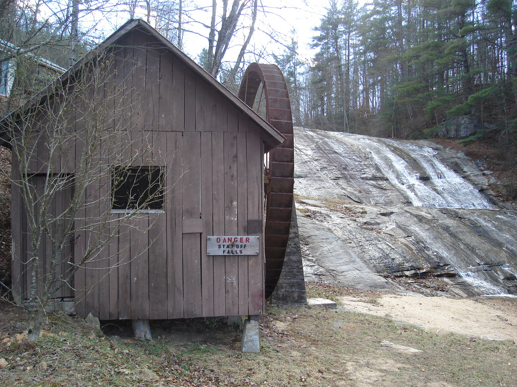
Moravian Falls, North Carolina — CDP — The waterfall and pumphouse at Moravian Falls Location of Moravian Falls, North Carolina
Coordinates: 36°6′22″N 81°10′34″W / 36.10611°N 81.17611°WCoordinates: 36°6′22″N 81°10′34″W / 36.10611°N 81.17611°W Country United States State North Carolina County Wilkes Area - Total 5.1 sq mi (13.2 km2) - Land 5.1 sq mi (13.2 km2) - Water 0.0 sq mi (0.0 km2) Elevation 1,194 ft (364 m) Population (2000) - Total 1,440 - Density 283.0/sq mi (109.3/km2) Time zone Eastern (EST) (UTC-5) - Summer (DST) EDT (UTC-4) ZIP code 28654 Area code(s) 336 FIPS code 37-44280[1] GNIS feature ID 0990215[2] Moravian Falls (formerly, Petersburg and Forks of the Road)[3] is a census-designated place (CDP) in Wilkes County, North Carolina, United States. The population was 1,440 as of the 2000 census.
Contents
Geography
Moravian Falls is located at 36°6′22″N 81°10′34″W / 36.10611°N 81.17611°W (36.106113, -81.176105)[4]. According to the United States Census Bureau, the CDP has a total area of 5.1 square miles (13 km2), of which, 5.1 square miles (13 km2) of it is land and 0.20% is water.
Background
Moravian Falls takes its name from a waterfall in the foothills of the Brushy Mountains, which rise just 2 to 3 miles (4.8 km) to the south of the community. Pores Knob, the highest peak in the Brushy Mountains, is located in Moravian Falls. The area was originally settled by members of the Moravian Church in 1753, and Moravians owned the waterfall for many years (the waterfall is named after the church). Today the waterfall is a tourist attraction owned by Ken Wike who operates a history rich family campground(Moravian Falls Family Campground). People travel from all over the U.S. to enjoy the peaceful beauty of nature. Wilkes Central High School, and Central Wilkes Middle School, are located in the community. The two schools are the largest and most ethnically diverse high school and middle school respectively in all of Wilkes County.
Demographics
As of the census[1] of 2000, there were 1,440 people, 600 households, and 415 families residing in the CDP. The population density was 283.0 people per square mile (109.2/km²). There were 656 housing units at an average density of 128.9 per square mile (49.8/km²). The racial makeup of the CDP was 89.58% White, 5.49% African American, 0.14% Asian, 3.47% from other races, and 1.32% from two or more races. Hispanic or Latino of any race were 7.15% of the population.
There were 600 households out of which 26.2% had children under the age of 18 living with them, 55.5% were married couples living together, 10.2% had a female householder with no husband present, and 30.7% were non-families. 26.5% of all households were made up of individuals and 7.7% had someone living alone who was 65 years of age or older. The average household size was 2.39 and the average family size was 2.86.
In the CDP the population was spread out with 22.0% under the age of 18, 9.1% from 18 to 24, 29.0% from 25 to 44, 25.8% from 45 to 64, and 14.1% who were 65 years of age or older. The median age was 38 years. For every 100 females there were 97.8 males. For every 100 females age 18 and over, there were 97.7 males.
The median income for a household in the CDP was $36,607, and the median income for a family was $48,906. Males had a median income of $21,911 versus $24,013 for females. The per capita income for the CDP was $19,405. About 5.7% of families and 12.4% of the population were below the poverty line, including 18.1% of those under age 18 and 13.3% of those age 65 or over.
References
- ^ a b "American FactFinder". United States Census Bureau. http://factfinder.census.gov. Retrieved 2008-01-31.
- ^ "US Board on Geographic Names". United States Geological Survey. 2007-10-25. http://geonames.usgs.gov. Retrieved 2008-01-31.
- ^ *U.S. Geological Survey Geographic Names Information System: Moravian Falls, North Carolina
- ^ "US Gazetteer files: 2010, 2000, and 1990". United States Census Bureau. 2011-02-12. http://www.census.gov/geo/www/gazetteer/gazette.html. Retrieved 2011-04-23.
External links
Municipalities and communities of Wilkes County, North Carolina Towns Elkin‡ | North Wilkesboro | Ronda | Wilkesboro
CDPs Boomer | Cricket | Fairplains | Hays | Millers Creek | Moravian Falls | Mulberry | Pleasant Hill
Footnotes ‡This populated place also has portions in an adjacent county or counties
Categories:- Census-designated places in North Carolina
- Populated places in Wilkes County, North Carolina
- Populated places established in 1753
- History of the America (South) Province of the Moravian Church


Wikimedia Foundation. 2010.