- Maysville, North Carolina
-
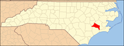
Maysville, North Carolina — Town — Location of Maysville, North Carolina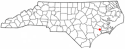
Coordinates: 34°54′16″N 77°13′44″W / 34.90444°N 77.22889°WCoordinates: 34°54′16″N 77°13′44″W / 34.90444°N 77.22889°W Country United States State North Carolina County Jones Area – Total 0.8 sq mi (2.0 km2) – Land 0.8 sq mi (2.0 km2) – Water 0.0 sq mi (0.0 km2) Elevation 39 ft (12 m) Population (2008) – Total 959 – Density 1,326.8/sq mi (512.3/km2) Time zone Eastern (EST) (UTC-5) – Summer (DST) EDT (UTC-4) ZIP code 28555 Area code(s) 910 FIPS code 37-42100[1] GNIS feature ID 1013382[2] Maysville is a town in Jones County, North Carolina, United States. The population was 959 in 2008. It is part of the New Bern, North Carolina Micropolitan Statistical Area.
Contents
Geography
Maysville is located at 34°54′16″N 77°13′44″W / 34.90444°N 77.22889°W (34.904581, -77.228969)[3].
According to the United States Census Bureau, the town has a total area of 0.8 square miles (2.1 km2), all of it land.
Demographics
As of the census[1] of 2000, there were 1,002 people, 389 households, and 255 families residing in the town. The population density was 1,326.8 people per square mile (509.0/km²). There were 483 housing units at an average density of 639.6 per square mile (245.4/km²). The racial makeup of the town was 40.82% White, 55.89% African American, 0.30% Native American, 0.30% Asian, 0.30% Pacific Islander, 1.40% from other races, and 1.00% from two or more races. Hispanic or Latino of any race were 2.20% of the population.
There were 389 households out of which 34.4% had children under the age of 18 living with them, 39.3% were married couples living together, 20.3% had a female householder with no husband present, and 34.2% were non-families. 29.8% of all households were made up of individuals and 12.6% had someone living alone who was 65 years of age or older. The average household size was 2.58 and the average family size was 3.20.
In the town the population was spread out with 30.1% under the age of 18, 6.9% from 18 to 24, 28.7% from 25 to 44, 19.7% from 45 to 64, and 14.6% who were 65 years of age or older. The median age was 35 years. For every 100 females there were 96.9 males. For every 100 females age 18 and over, there were 88.7 males.
The median income for a household in the town was $27,750, and the median income for a family was $34,688. Males had a median income of $30,104 versus $19,048 for females. The per capita income for the town was $11,119. About 19.9% of families and 26.2% of the population were below the poverty line, including 31.1% of those under age 18 and 20.0% of those age 65 or over.
Town Administration
Day-to-day government operations are run by a town manager. There is a town board that meets on the first Thursday of each month and a part-time mayor.
Education
- Silverdale Elementary School
- Maysville Elementary School
References
- ^ a b "American FactFinder". United States Census Bureau. http://factfinder.census.gov. Retrieved 2008-01-31.
- ^ "US Board on Geographic Names". United States Geological Survey. 2007-10-25. http://geonames.usgs.gov. Retrieved 2008-01-31.
- ^ "US Gazetteer files: 2010, 2000, and 1990". United States Census Bureau. 2011-02-12. http://www.census.gov/geo/www/gazetteer/gazette.html. Retrieved 2011-04-23.
Municipalities and communities of Jones County, North Carolina Towns Maysville | Pollocksville | Trenton
 Categories:
- Populated places in Jones County, North Carolina
- Towns in North Carolina
- New Bern micropolitan area


Wikimedia Foundation. 2010.