- Nanjing Road (Shanghai)
-
For other uses, see Nanjing Road (disambiguation).
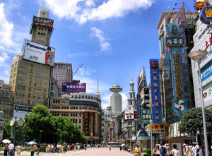
 Nanjing Road is one of the world's busiest shopping streets.[1]
Nanjing Road (Chinese: 南京路; pinyin: Nánjīng Lù) is the main shopping street of Shanghai, China, and is one of the world's busiest shopping streets.[1] Today's Nanjing Road comprises two sections, Nanjing Road East and Nanjing Road West. In some contexts, "Nanjing Road" refers only to what was pre-1945 Nanjing Road, today's Nanjing Road East, which is largely pedestrianised. Prior to 1949, the road's English name was rendered "Nanking Road" using the standard romanization of the time.
Contents
Location
Nanjing Road is located in the city center, running in a west-east direction. Its eastern section (南京东路) is in Huangpu District (黄浦区) and extends from The Bund (Wai Tan-外滩) west to People's Square. The western section (南京西路) begins at People's Square and continues westward towards Jing'an District.
History
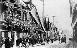
 Nanjing Road after the 1911 Xinhai Revolution full of the Five Races Under One Union Flags then used by the revolutionaries
The history of Nanjing Road can be traced back to the year 1845.[2] At that time it was called “Park Lane”, which streched from the Bund to He’nan Road. In 1854, it was extended to Zhejiang Road, and eight years later, once more extended to Xizang Road. In 1862, it was named formally “Nanking Road”[2] by the Municipal Council, which administered the International Settlement. In Chinese it was usually referred to as the Main Road (大马路). Around 1930 it was a bustling street with at least one reported casino (probably at nr. 181).[citation needed] In 1943 the International Settlement was annulled, and after World War Two the government changed its name from Nanking Road to "East Nanjing Road", meanwhile they also renamed the former Bubbling Well Road "West Nanjing Road", and the general name of the two roads became "Nanjing Road", comprising five kilometres total length.
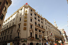
At the beginning of the 20th century, eight big department stores were established along the street. A series of franchised stores were also set up at that time.
On 23 August 1937 a bomb was dropped on Nanjing Road by a Chinese plane in an attempt to lighten its load while being pursued by Japanese planes. The bomb hit two department stores, killing 612 people and injuring another 482.[2]
In 2000, as a part of the development plan held by the local government, Nanjing Road was renovated to be a characteristic pedestrian street. The width is about 28 meters and the total length is 1,200 meters, which extends from Middle He'nan Road to Middle Xizang Road.
In 2007, the Jingan and Huangpu governments agreed to coordinate their policy to enhance the development of Nanjing Road, through a unique launching of a committee. This agreement followed a request by the committee of Champs-Elysees in the perspective of a friendship agreement between both famous streets.
Description
Nanjing Road is the world's longest shopping district, around 6 km long, and attracts over 1 million visitors daily.[citation needed]
Nanjing Road East
East Nanjing Road is a dedicated commercial zone. At its eastern end is the central section of the Bund, featuring the Peace Hotel. Immediately west of the Bund precinct was traditionally the hub of European-style restaurants and cafes, although in recent years these have become less of a feature as the demographics of visitors to Nanjing Road have shifted from affluent local residents to visitors from around the country. Close by is the Central Market, a century-old outdoor market today specialising in electronic components and digital media. Further west is the Nanjing Road pedestrian mall. Located here are most of Shanghai's oldest and largest department stores, as well as a variety of domestic retail outlets, and some traditional eateries with a long history.
Nanjing Road West
The pedestrian mall, and East Nanjing Road, ends at People's Park, formerly the Shanghai Race Course. Opposite the park are some of Shanghai's prestigious historic hotels, including Park Hotel. West Nanjing Road begins here, and features a number of upmarket malls, office buildings, the Shanghai Exhibition Centre, and shops. This area also previously featured a number of large mansions and estates, most of which are today either demolished or used by the government.
West Nanjing Road, near Jing'an Temple, has witnessed constant development over the past ten years. This area is now host to several five star hotels, upscale shopping centers, restaurants and prime office buildings. Recently, the area has benefited from the construction of Subway Line 7, connecting with Line 2 at Jing’an Temple station. The latest development here was the completion of the Wheelock Square building, completed in 2010, with 58 floors and just over 100,000 sq meters of prime office space.[3]
Transportation
Shanghai Metro Line 2 runs along Nanjing Road, including the following stations and other stations:
- Nanjing Road (E.) (formerly Henan Zhong Road), closest station to the pedestrianised part of East Nanjing Road and The Bund
- People's Square, the metro station on People's Square in the middle of Nanjing Road.
- Nanjing Road (W.) (formerly Shimen No. 1 Road), at the beginning of the western section of the street, close to People's Square.[clarification needed]
- Jing'an Temple, in the farther western section of Nanjing Road.
Events
Tourists and guests often celebrate various holidays at Nanjing Road, such as the Chinese New Year, New Year's Eve, Christmas and Easter. Some parts of the buildings and shopping malls seen in front of Nanjing Road may host a fireworks display over the street.
References
- ^ a b "Nanjing Road Shopping Mall Shanghai". AsiaRooms - TUI Travel PLC. http://www.asiarooms.com/travel-guide/china/shanghai/things-to-do-in-shanghai/shopping-in-shanghai/nanjing-road-shopping-mall-shanghai.html.
- ^ a b c Warr, Anne: Shanghai Architecture, The Watermark Press, 2007, ISBN 9780949284761
- ^ Knight Frank China Knight Frank China Research, Shanghai District Overview, Jing'an
See also
Municipality of Shanghai History • Geography • Politics • Economy • Architecture Administrative divisions County Areas Culture and demographics Attractions Jinjiang Action Park • Nanjing Road • Shanghai Concert Hall • Shanghai Grand Theatre • Shanghai New International Expo Center • Shanghai Zoo • Yuyuan GardenMuseums Parks Places of Worship ChristianOtherSports venues Towers Transport Hongqiao International Airport • Pudong International Airport • Shanghai Metro • Shanghai Public Transportation Card • Maglev Train • Shanghai Railway Station • Shanghai South Railway Station • Hongqiao Railway Station • Trams in Shanghai • Zhangjiang Tram • Shanghai Bus • Trolleybuses in ShanghaiUniversities Major hotels  Category
Coordinates: 31°14′05″N 121°28′28″E / 31.23472°N 121.47444°E
Categories:- Shanghai culture
- Shopping districts and streets in China
- Visitor attractions in Shanghai
- Landmarks in Shanghai
- Streets in Shanghai
- Pedestrian malls
Wikimedia Foundation. 2010.


