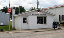
- Cutler, Indiana
-
Cutler — Town — Coordinates: 40°28′35″N 86°31′27″W / 40.47639°N 86.52417°WCoordinates: 40°28′35″N 86°31′27″W / 40.47639°N 86.52417°W Country United States State Indiana County Carroll Township Democrat Elevation 751 ft (229 m) ZIP code 46920 FIPS code 18-16480[1] GNIS feature ID 433265[2] Cutler is an unincorporated town in Democrat Township, Carroll County, Indiana, United States. It is part of the Lafayette, Indiana Metropolitan Statistical Area.
Geography
Cutler is located at 40°28′35″N 86°31′27″W / 40.47639°N 86.52417°W. The town was laid out by John A. Cook during the construction of the Logansport Crawfordsville & Southwestern Rail Road sometime in 1871. It was named by him, probably from the man in charge of the construction, William P. Cutler.
References
- ^ "American FactFinder". United States Census Bureau. http://factfinder.census.gov. Retrieved 2008-01-31.
- ^ "Cutler, Indiana". Geographic Names Information System, U.S. Geological Survey. http://geonames.usgs.gov/pls/gnispublic/f?p=gnispq:3:::NO::P3_FID:433265. Retrieved 2009-10-10.
Municipalities and communities of Carroll County, Indiana City Towns Burlington | Camden | Flora | Yeoman
Townships Adams | Burlington | Carrollton | Clay | Deer Creek | Democrat | Jackson | Jefferson | Liberty | Madison | Monroe | Rock Creek | Tippecanoe | Washington
Unincorporated
communitiesAdams Mill | Breezy Point | Bringhurst | Burrows | C and C Beach | Carrollton | Cutler | Deer Creek | Gingrich Addition | Lakewood | Lexington | Lockport | Lower Sunset Park | Ockley | Owasco | Patton | Pittsburg | Prince William | Pyrmont | Radnor | Rockfield | Roth Park | Sandy Beach | Scarlet Oaks | Sharon | Sleeth | Terrace Bay | Upper Sunset Park | Walnut Gardens | Wheeling
Categories:- Populated places in Carroll County, Indiana
- Unincorporated communities in Indiana
- Lafayette, Indiana metropolitan area
- Northern Indiana geography stubs
Wikimedia Foundation. 2010.


