- Questa, New Mexico
Infobox Settlement
official_name = The Village of Questa
settlement_type = Village
nickname =
motto =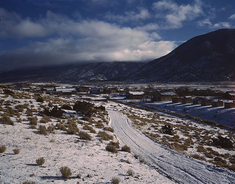
imagesize = 250px
image_caption = Questa in 1943.
image_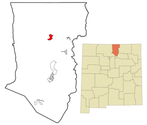
mapsize = 250px
map_caption = Location of Questa, New Mexico
mapsize1 =
map_caption1 =subdivision_type = Country
subdivision_name =United States
subdivision_type1 = State
subdivision_name1 =New Mexico
subdivision_type2 = County
subdivision_name2 = Taos
government_footnotes =
government_type =
leader_title =
leader_name =
leader_title1 =
leader_name1 =
established_title =
established_date =unit_pref = Imperial
area_footnotes =area_magnitude =
area_total_km2 = 13.2
area_land_km2 = 13.2
area_water_km2 = 0.0
area_total_sq_mi = 5.1
area_land_sq_mi = 5.1
area_water_sq_mi = 0.0population_as_of = 2000
population_footnotes =
population_total = 1864
population_density_km2 = 140.9
population_density_sq_mi = 365.0timezone = Mountain (MST)
utc_offset = -7
timezone_DST = MDT
utc_offset_DST = -6
elevation_footnotes =
elevation_m = 2274
elevation_ft = 7461
latd = 36 |latm = 42 |lats = 23 |latNS = N
longd = 105 |longm = 35 |longs = 35 |longEW = Wpostal_code_type =
ZIP code
postal_code = 87556
area_code = 505
blank_name = FIPS code
blank_info = 35-60870
blank1_name = GNIS feature ID
blank1_info = 0909932
website =
footnotes =Questa is a village in Taos County,
New Mexico ,United States . The population was 1,864 at the 2000 census. Located on the northwest side of the beautiful Enchanted Circle highway, near the confluence of theRio Grande and the Red River, Questa is the least tourist-oriented town on the route. With a largeHispanic population, the village economy is largely dependent on agriculture and income from the nearby Molycorp Questamolybdenum mine. Many residents also commute to Taos, Red River, and Angel Fire to work in the hospitality industries there.Geography
Questa is located at coor dms|36|42|23|N|105|35|35|W|city (36.706302, -105.593058).GR|1
According to the
United States Census Bureau , the village has a total area of 5.1square mile s (13.2km² ), all of it land. The village is a regional hub for the smaller outlying communities of Lama, Cerro, Sunshine Valley, Latir, Costilla, and Amalia.Questa lies at the western base of the
Taos Mountains , part of theSangre de Cristo Mountains . Rising above the town to the northeast is theLatir Peak massif , headed byVenado Peak , Convert|12734|ft|m|0|abbr=on; Pinabete Peak, a southwestern outlier of the group, rises closest to Questa. To the southeast lies Flag Mountain, a northwestern spur of the group of mountains that includes Wheeler Peak, the highest peak in New Mexico. To the north and west lie theRio Grande Gorge , cutting avolcanic plateau dotted with several peaks of volcanic origin.Demographics
As of the
census GR|2 of 2000, there were 1,864 people, 741 households, and 512 families residing in the village. Thepopulation density was 365.0 people per square mile (140.8/km²). There were 888 housing units at an average density of 173.9/sq mi (67.1/km²). The racial makeup of the village was 50.16% White, 0.11% African American, 0.70% Native American, 0.05% Asian, 0.11% Pacific Islander, 43.40% from other races, and 5.47% from two or more races. Hispanic or Latino of any race were 80.53% of the population.There were 741 households out of which 35.6% had children under the age of 18 living with them, 49.3% were married couples living together, 13.8% had a female householder with no husband present, and 30.8% were non-families. 26.5% of all households were made up of individuals and 9.9% had someone living alone who was 65 years of age or older. The average household size was 2.52 and the average family size was 3.02.
In the village the population was spread out with 28.0% under the age of 18, 7.4% from 18 to 24, 26.3% from 25 to 44, 25.4% from 45 to 64, and 12.9% who were 65 years of age or older. The median age was 38 years. For every 100 females there were 95.4 males. For every 100 females age 18 and over, there were 95.3 males.
The median income for a household in the village was $23,448, and the median income for a family was $30,000. Males had a median income of $26,667 versus $20,000 for females. The
per capita income for the village was $13,303. About 20.7% of families and 24.3% of the population were below thepoverty line , including 29.8% of those under age 18 and 20.4% of those age 65 or over.History
Questa was originally named San Antonio del Rio Colorado. Later, a U.S.
postmaster changed its name to Questa. [ [http://www.laplaza.org/government/questa/ Questa Home Page ] ] The postmaster misspelled the name — according to Spanish spelling rules, it should have been spelled Cuesta, which was derived from the Spanish for "ridge" or "slope." Despite the error, the village has kept the name.The village of Questa is located close to the ancient Kiowa trail, a Native American trade route which connected the Ute,
Kiowa , andComanche tribes to the north with the Pueblo tribes to the south. Evidence of this route can be seen in trail remnants, artifacts, and petroglyphs along the western slopes of theSangre de Cristo Mountains (Rael and Cuddihy, 2003). The first Hispanic visitor to the area may have beenFrancisco Vásquez de Coronado ; certainly the area was known to the Spanish by 1593, when the gold-seekers Juan Humana and Fransisco Borilla were killed by tribes along the Purgatory river.Mining activity in the area, including the apocryphal Governor's mine (NM Bureau of Geology and Mineral Resources, RM-21), probably began around that time, and continued until the
Pueblo Revolt of 1680. The use of forced labor in gold mining is often cited as the cause of the revolt, but records of that time are incomplete, and the locations of these mines are lost. Candidates for "Lost Spanish Gold Mines" are frequently proposed in the Sangre de Cristo, San Juan, and Ortiz Mountains; few have been verified.After the Pueblo Revolt, Spanish occupation was slow to return to the Questa area due to repeated clashes with Taos and Ute warriors; although reports of trading and military activity in the area, especially by French, French-Canadian, and even English fur traders, the actual date of establishment of a permanent settlement in the area is recorded as 1820 (Rael and Cuddihy, 2003). Even then, the threat of Indian raids was considerable. The location of the incipient village at the confluence of the rivers, and astride the ancient trade, raiding, and hunting routes, made resource-based conflict between cultures inevitable. Additionally, the village location blocked access to certain historic clay and pigment quarries of great ceremonial importance to the Taos tribe. This continued conflict lead to the village being repeated abandoned. Spanish, Mexican, and eventually American soldiers detailed to defend the beleaguered settlement frequently expressed great frustration with their posting (Rael and Cuddihy, 2003).
The names of two prominent peaks overlooking the village of Questa, Flag Mountain and Sentinel Peak, refer to the practice, during this period, of stationing watchmen on these high points to warn the village of approaching war parties.
The village, nearly from the beginning, was of mixed blood; the surnames Lafore or Laforet, Ledoux, and LaCome reflect the names of French or French-Canadian trappers who settled in the area after arriving in search of otter and beaver. The common surname Rael may also reflect the influence of Jewish immigrants arriving after being expelled from Mexico. The village had a reputation for being contentious and requiring disproportionate effort to police; records show that viceregal intervention was frequently required to settle property disputes (Rael and Cuddihy, 2003).
The R&S Molybdenum mine, seven miles up the Red River Canyon from Questa, was founded in 1916. Through many changes of ownership and organization, the mine survives today as the Molycorp Questa mine, the main source of employment for the community.
Economy
The main source of income for the village of Questa is the Molycorp Questa mine.
Agriculture, especially the cultivation of alfalfa, hay, and winter wheat is of decreasing importance. Agriculture in Questa is strongly dependent on irrigation, supplied from the Red River and Cabresto Creek. The system of ditches or acequias which supply water to the fields are of great community and social importance; the burning of the ditches on the first weekend after the vernal equinox is a major community event. Two major 'ditch associations' control the distribution of water by controlling the outflow from the Cabresto Lake dam: the Acequia Madre and the Llano ditch.
Historically, sheep were raised in and around Questa, but they have been replaced by cattle. Cattle are grazed on the plains north and west of town during the winter and spring, then moved west to the other side of the Rio Grande in early June, usually driven across the "Sheep Crossing" ford by riders on horseback.
Increasingly, the traditional economy based on agriculture, livestock, handicrafts (particularly wooden religious carvings known as santos), wood gathering, and honey is failing to meet the financial needs of the populace of Questa. Some locals blame the rising cost on the influx of celebrities and affluent Anglos to the Taos area driving up land and home prices, but for whatever cause, and increasing number of Questenos commute to work in Red River, Taos and Angel Fire.
References
External links
* [http://www.taosnews.com/ The Taos News - The newspaper of record for Taos County]
* [http://www.taoslink.com/ taoslink.com more than 1600 genuine Taos web sites]

Wikimedia Foundation. 2010.