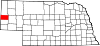
- McGrew, Nebraska
-
McGrew, Nebraska — Village — Location of McGrew, Nebraska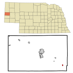
Coordinates: 41°44′45″N 103°25′4″W / 41.74583°N 103.41778°WCoordinates: 41°44′45″N 103°25′4″W / 41.74583°N 103.41778°W Country United States State Nebraska County Scotts Bluff Area - Total 0.4 sq mi (1.0 km2) - Land 0.4 sq mi (1.0 km2) - Water 0.0 sq mi (0.0 km2) Elevation 3,783 ft (1,153 m) Population (2000) - Total 103 - Density 268.6/sq mi (103.7/km2) Time zone Mountain (MST) (UTC-7) - Summer (DST) MDT (UTC-6) ZIP code 69353 Area code(s) 308 FIPS code 31-30030[1] GNIS feature ID 0831142[2] McGrew is a village in Scotts Bluff County, Nebraska, United States. It is part of the Scottsbluff, Nebraska Micropolitan Statistical Area. The population was 103 at the 2000 census.
Geography
McGrew is located at 41°44′45″N 103°25′4″W / 41.74583°N 103.41778°W (41.745914, -103.417687)[3].
According to the United States Census Bureau, the village has a total area of 0.4 square miles (1.0 km2), all of it land.
Demographics
As of the census[1] of 2000, there were 103 people, 46 households, and 29 families residing in the village. The population density was 268.6 people per square mile (104.7/km²). There were 51 housing units at an average density of 133.0 per square mile (51.8/km²). The racial makeup of the village was 90.29% White, 5.83% from other races, and 3.88% from two or more races. Hispanic or Latino of any race were 15.53% of the population.
There were 46 households out of which 21.7% had children under the age of 18 living with them, 47.8% were married couples living together, 13.0% had a female householder with no husband present, and 34.8% were non-families. 28.3% of all households were made up of individuals and 6.5% had someone living alone who was 65 years of age or older. The average household size was 2.24 and the average family size was 2.67.
In the village the population was spread out with 21.4% under the age of 18, 3.9% from 18 to 24, 27.2% from 25 to 44, 33.0% from 45 to 64, and 14.6% who were 65 years of age or older. The median age was 44 years. For every 100 females there were 114.6 males. For every 100 females age 18 and over, there were 113.2 males.
The median income for a household in the village was $23,750, and the median income for a family was $25,000. Males had a median income of $20,625 versus $18,750 for females. The per capita income for the village was $12,078. There were 3.6% of families and 9.8% of the population living below the poverty line, including 21.4% of under eighteens and none of those over 64.
References
- ^ a b "American FactFinder". United States Census Bureau. http://factfinder.census.gov. Retrieved 2008-01-31.
- ^ "US Board on Geographic Names". United States Geological Survey. 2007-10-25. http://geonames.usgs.gov. Retrieved 2008-01-31.
- ^ "US Gazetteer files: 2010, 2000, and 1990". United States Census Bureau. 2011-02-12. http://www.census.gov/geo/www/gazetteer/gazette.html. Retrieved 2011-04-23.
Municipalities and communities of Scotts Bluff County, Nebraska County seat: Gering Cities Gering | Minatare | Mitchell | Scottsbluff
Villages Categories:- Populated places in Scotts Bluff County, Nebraska
- Villages in Nebraska
- Scottsbluff micropolitan area

Wikimedia Foundation. 2010.