Old Town (Staten Island Railway station)
- Old Town (Staten Island Railway station)
-
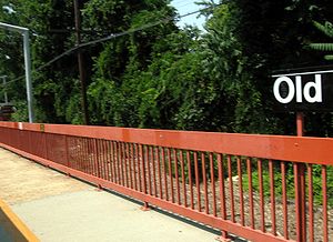
Old Town is a Staten Island Railway station in the neighborhood of Old Town, Staten Island, New York. It is located on an embankment at Railroad Avenue on the main line. It has two side platforms, and metal orange canopies and walls. The exit at the south end leads to Old Town Road while an additional staircase at the north end of the northbound platform leads to a roadway to Dawson Place and Oregon Road. Just south of this station, there is a spur that formerly served the press building of the Staten Island Advance newspaper that is nowadays used as a storage spur for ballast cars.
References
- ^ Irvin Leigh and Paul Matus (December 23, 2001). "SIRT The Essential History". p. 4. http://www.thethirdrail.net/0201/sirt4.html. Retrieved 2009-03-03.
External links
Categories: - New York City transportation stubs
- Staten Island Railway stations
Wikimedia Foundation.
2010.
Look at other dictionaries:
Old Town, Staten Island — Old Town is a neighborhood in the New York City borough of Staten Island, located on its East Shore. Old Town was established in August 1661 as part of New Netherland, and was the first permanent European settlement on Staten Island.[1]… … Wikipedia
Dongan Hills (Staten Island Railway station) — Dongan Hills Staten Island Railway rapid transit station … Wikipedia
Grasmere (Staten Island Railway station) — Infobox NYCS name = Grasmere image caption = Platform SIR = yes font color = white bg color = black platforms = 1 island platform tracks = 2 borough = Staten Island open date = Unknown north custom station = Clifton south custom station = Old… … Wikipedia
Staten Island Railway — Streckenlänge: 22,5 km Spurweite: 1435 mm (Normalspur) Stromsystem: 660 V … Deutsch Wikipedia
Staten Island Railway — Trajet du SIR Le Staten Island Railway (ou SIR) est un réseau de transport métropolitain dans le borough de Staten Island, à New York. Bien qu étant considéré comme un réseau classique de chemin de fer, le SIR utilise des rames de type R44[1] … Wikipédia en Français
Staten Island Railway — Infobox rail line name = Staten Island Railway logo width = 225px image width = 300px caption = An SIR rush hour local train discharges passengers at the Great Kills SIR station, its final stop. type = Rapid transit system = status = Operational… … Wikipedia
Old Town Road — Length: 0.40 mi (0.64 km) Location: Richmond West end: Richmond Road/Dellwood Road East end: Hylan Boulevard/Quintard Street Old Town Road is a short but primary east west artery in … Wikipedia
Staten Island — Infobox Settlement name = Staten Island official name = Richmond County other name = native name = nickname = settlement type =Borough of New York City total type = motto = imagesize = image caption = Staten Island streets with views of the… … Wikipedia
Pleasant Plains, Staten Island — Pleasant Plains is a neighborhood located on Staten Island, one of the five boroughs of New York City, New York, the most populous city in the United States. Welcome To Pleasant Plains sign (Amboy Rd. Facing south,corner of Pleasant Plains Ave.;… … Wikipedia
Clifton, Staten Island — View from the Staten Island Railway platform in Clifton, looking towards the Narrows … Wikipedia