- Greater Carrollwood, Florida
Infobox Settlement
official_name = Greater Carrollwood, Florida
other_name =
native_name =
nickname =
settlement_type = CDP
motto =
imagesize =
image_caption =
flag_size =
image_
seal_size =
image_shield =
shield_size =
image_blank_emblem =
blank_emblem_type =
blank_emblem_size =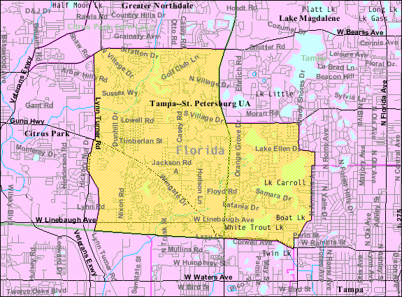
mapsize = 250px
map_caption =U.S. Census map of Greater Carrollwood, Florida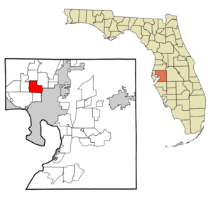
mapsize1 = 250x200px
map_caption1 = Location in Hillsborough County and the state ofFlorida
image_dot_
dot_mapsize =
dot_map_caption =
dot_x =
dot_y =
pushpin_
pushpin_label_position =
pushpin_map_caption =
pushpin_mapsize =
subdivision_type = Country
subdivision_name = flag|United States
subdivision_type1 = State
subdivision_name1 = flag|Florida
subdivision_type2 = County
subdivision_name2 = noflag|Hillsborough
subdivision_type3 =
subdivision_name3 =
subdivision_type4 =
subdivision_name4 =
government_footnotes =
government_type =
leader_title =
leader_name =
leader_title1 =
leader_name1 =
leader_title2 =
leader_name2 =
leader_title3 =
leader_name3 =
leader_title4 =
leader_name4 =
established_title =
established_date =
established_title2 =
established_date2 =
established_title3 =
established_date3 =
area_magnitude =
unit_pref = Imperial
area_footnotes =
area_total_km2 = 26.7
area_land_km2 = 24.8
area_water_km2 = 1.9
area_total_sq_mi = 10.3
area_land_sq_mi = 9.6
area_water_sq_mi = 0.7
area_water_percent =
area_urban_km2 =
area_urban_sq_mi =
area_metro_km2 =
area_metro_sq_mi =
area_blank1_title =
area_blank1_km2 =
area_blank1_sq_mi =
population_as_of = 2000
population_footnotes =
population_note =
population_total = 33519
population_density_km2 = 1255.4
population_density_sq_mi = 3254.3
population_metro =
population_density_metro_km2 =
population_density_metro_sq_mi =
population_urban =
population_density_urban_km2 =
population_density_urban_sq_mi =
population_blank1_title =
population_blank1 =
population_density_blank1_km2 =
population_density_blank1_sq_mi =
timezone = Eastern (EST)
utc_offset = -5
timezone_DST = EDT
utc_offset_DST = -4
latd = 28 |latm = 3 |lats = 29 |latNS = N
longd = 82 |longm = 30 |longs = 55 |longEW = W
elevation_footnotes =
elevation_m =
elevation_ft =
postal_code_type =
postal_code =
area_code =
blank_name = FIPS code
blank_info = 12-27313GR|2
blank1_name =
blank1_info =
website =
footnotes =Greater Carrollwood is a
census-designated place and an unincorporated census area located in northwestern Hillsborough County,Florida ,United States . The population was 33,519 at the 2000 census. The census area includes the separate community of Carrollwood and other planned developments.ZIP code
The
ZIP code for Greater Carrollwood is 33618 and 33624. As is the case with other communities outside the official city limits ofTampa (such as the University area and East Lake) physical addresses and United States Post Office mail are addressed to Tampa, as Carrollwood cannot be used as a physical address or mailpoint.Geography
Carrollwood is located at coor dms|28|3|29|N|82|30|55|W|city (28.058166, -82.515413)GR|1; or about 7 miles NNW of Tampa.
According to the
United States Census Bureau , the community has a total area of 10.3square mile s (26.6km² ), of which, 9.6 square miles (24.8 km²) of it is land and 0.7 square miles (1.8 km²) of it (6.91%) is water.Demographics
As of the
census GR|2 of 2000, there were 33,519 people, 13,897 households, and 9,158 families residing in the community. Thepopulation density was 3,502.8 people per square mile (1,352.3/km²). There were 14,483 housing units at an average density of 1,513.5/sq mi (584.3/km²). The racial makeup of the community was 84.49% White, 5.85% African American, 0.24% Native American, 3.46% Asian, 0.05% Pacific Islander, 3.36% from other races, and 2.55% from two or more races. Hispanic or Latino of any race were 18.29% of the population.There were 13,897 households out of which 31.3% had children under the age of 18 living with them, 52.0% were married couples living together, 10.7% had a female householder with no husband present, and 34.1% were non-families. 26.8% of all households were made up of individuals and 6.3% had someone living alone who was 65 years of age or older. The average household size was 2.41 and the average family size was 2.95.
In the community the population was spread out with 23.8% under the age of 18, 7.3% from 18 to 24, 32.9% from 25 to 44, 25.2% from 45 to 64, and 10.7% who were 65 years of age or older. The median age was 37 years. For every 100 females there were 91.2 males. For every 100 females age 18 and over, there were 86.9 males.
The median income for a household in the community was $50,833, and the median income for a family was $61,223. Males had a median income of $39,529 versus $31,200 for females. The
per capita income for the community was $29,107. About 3.3% of families and 5.0% of the population were below thepoverty line , including 4.7% of those under age 18 and 3.3% of those age 65 or over.References
External links
* [http://www.carrollwood.com Carrollwood's website]

Wikimedia Foundation. 2010.