- 2005 Sumatra earthquake
Earthquake
title = 2005 Sumatra earthquake
date = 28 March 2005
magnitude = 8.7 Mw
location = coord|2|04|35|N|97|00|58|E|
depth = 30 km
countries affected =Indonesia
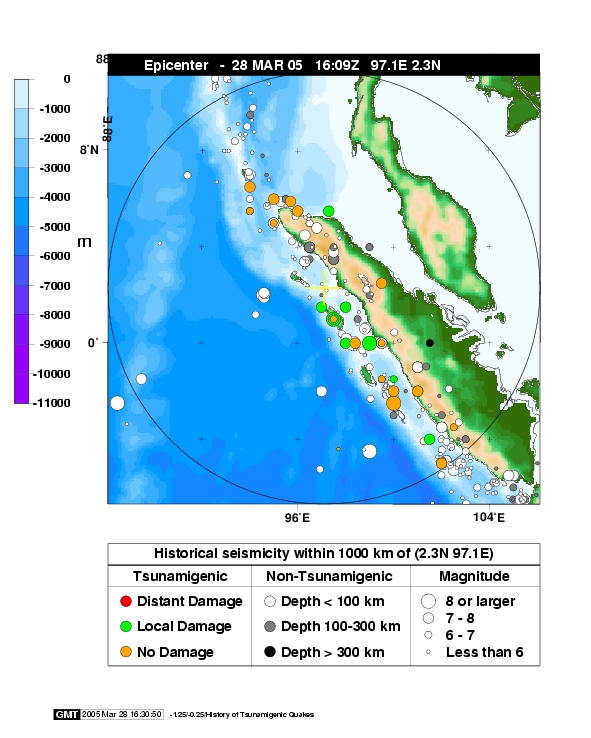
casualties = 1,300The 2005 Sumatra earthquake, referred to as the Nias Earthquake by the scientific community, was a major earthquake on 28 March 2005, located off the west coast of northernSumatra ,Indonesia . Approximately 1,300 people were killed by the earthquake, mostly on the island ofNias . The event caused panic in the region, which had previously been devastated by the massivetsunami triggered by the2004 Indian Ocean earthquake , but this earthquake generated a relatively tiny tsunami that caused limited damage. It was the 4th most powerful earthquake since 1964.The earthquake occurred at 16:09:36
UTC (11:09:36 P.M. local time) on 28 March 2005. Thehypocenter was located at coord|2|04|35|N|97|00|58|E|, convert|30|km|mi below the surface of theIndian Ocean , wheresubduction is forcing theIndo-Australian Plate to the south-west under theEurasian plate 's Sunda edge. The area is convert|200|km|mi west ofSibolga ,Sumatra , or convert|1400|km|mi northwest ofJakarta , approximately halfway between the islands ofNias andSimeulue . Seismic recordings give theearthquake a magnitude of about 8.7, and effects were felt as far away asBangkok ,Thailand ; over convert|1000|km|mi away. [cite web|url=http://news.xinhuanet.com/english/2005-03/28/content_2755486.htm|title=Southern Thailand evacuated after Indonesian earthquake]
=Earthquake and daThe earthquake lasted for about two minutes in total. In the twenty-four hours immediately after the event, there were eight major aftershocks, measuring between 5.5 and 6.0. A debate arose among seismologists over whether this should be considered an aftershock of the December 2004 event, or a "triggered earthquake" as it was larger than typical aftershocks but on the same fault.
On the Indonesian island of
Nias , off the coast of Sumatra, hundreds of buildings were destroyed by the earthquake. The death toll on Nias was at least one thousand, with 220 dying inGunungsitoli , the island's largest town. Nearly half of Gunungsitoli's population (27,000) fled the town.The earthquake was strongly felt across the island of
Sumatra , and caused widespreadpower outage s in the Indonesian city ofBanda Aceh , already devastated by the December 2004 tsunami, and prompted thousands to flee their homes and seek higher ground.It was also strongly felt along the west coast of Thailand and Malaysia, and in
Kuala Lumpur high-rise buildings were evacuated. The earthquake was felt less strongly in theMaldives ,India , andSri Lanka .Tsunami
The earthquake caused great concern around the
Indian Ocean that it might trigger a tsunami similar to the massive one generated three months earlier by the2004 Indian Ocean earthquake on 26 December 2004. Evacuations were carried out in coastal regions ofThailand ,Malaysia , andSri Lanka . This earthquake, however, produced a relatively tiny tsunami. A convert|3|m|ft|adj=on tsunami caused moderate damage to port and airport facilities onSimeulue , and a convert|2|m|ft|adj=on tsunami was recorded on the west coast of Nias. Much smaller waves, most detectable only intide gauge recording systems, were recorded across the Indian Ocean; for example, a convert|25|cm|in wave was recorded atColombo, Sri Lanka .Tsunami warnings were issued by thePacific Tsunami Warning Center , operated by the USNational Oceanic and Atmospheric Administration (NOAA) , and by the government ofThailand . There were initial concerns that a major tsunami could be generated, particularly travelling south from the event's hypocenter.Portions of Thailand's southern coast were evacuated as a precaution, and NOAA advised an evacuation of convert|965|km|mi of coastline in Sumatra. Evacuations also occurred in the northern
Malaysia n states ofPenang andKedah , as well as the eastern coast ofSri Lanka , where ten people were killed in the confusion of the evacuation. Many of the southern states ofIndia were also put on high alert; all of these areas had seen significant damage from December's tsunami. After the detection of a minor tsunami south of the epicenter, including a 30 cm tsunami on Australia'sCocos Islands , the island states ofMauritius ,Madagascar , and theSeychelles in the Indian Ocean issued warnings to their populations.Although tsunami warning systems for the region had been actively discussed before the December 2004 earthquake, none had yet been implemented in the Indian Ocean.
Humanitarian response
The
United Nations worked with the Indonesian government to take further actions to prevent a possible catastrophe after the strong earthquake, and the USState Department has announced that it will help countries affected by a possible tsunami. The government ofIndia announced aid of US$2 million for the earthquake victims. [cite web|url=http://timesofindia.indiatimes.com/articleshow/1064806.cms|title=India announces $2 mn relief for Indonesia]Australia announced it would provide AU$1 million in emergency aid, and, at the request of the Indonesian Government, dispatchedAustralian Defence Force medical teams and equipment to Nias. The Australian naval ship HMAS Kanimbla, having only recently left Aceh, was redeployed to the region fromSingapore . At about 9:30 (UTC) 2 April 2005, one of Kanimbla's two Sea King helicopters,Shark 02 , crashed on the island of Nias while taking medical personnel to a village. Nine personnel were killed, and two others sustained injuries but were rescued from the site by the other helicopter. The crash occurred one day before astate visit by PresidentSusilo Bambang Yudhoyono to Australia, where he andPrime Minister of Australia John Howard expressed mutual sorrow for their countries' losses.References
External links
* [http://asc-india.org/lib/20050328-nias.htm Special Event Page, Amateur Seismic Centre, India]
* [http://www.navy.gov.au/Publication:Navy_Annual_2005/Operations_SUMATRA_ASSIST_I_and_II Royal Australian Navy assistance to earthquake relief]
* [http://earthquake.usgs.gov/eqcenter/eqinthenews/2005/usweax/ United States Geological Survey event page]
* [http://www.indonesia-relief.org/mod.php?mod=publisher&op=viewcat&cid=28 Indonesia-Relief.Org: Sumatra Earthquake]
*" [http://news.bbc.co.uk/2/hi/asia-pacific/4388579.stm Lethal quake rattles tsunami zone] " - BBC News
*" [http://edition.cnn.com/2005/WORLD/asiapcf/03/28/indonesia.quake/index.html Quake kills at least 300 on Indonesian island] " - CNN
* [http://rev.seis.sc.edu/earthquakes/2005/03/28/16/09/36 Seismograms for this earthquake via REV, the Rapid Earthquake Viewer]
*" [http://www.ctv.ca/servlet/ArticleNews/story/CTVNews/20070413/quake_coral_070413/20070413?hub=SciTech Earthquake causes coral reefs to die] " CTV News

Wikimedia Foundation. 2010.