- County Borough of Bolton
-
For other uses, see Bolton (disambiguation).
County Borough of Bolton Motto: Supera Moras (Latin: Overcome delays) [1] Geography Status Municipal borough 1838–1889,
County borough 1889–19741911 area 15,279 acres (61.8 km2)[2] 1971 area 15,280 acres (61.8 km2)[2] HQ Bolton Town Hall History Created 1838 Abolished 1974 Succeeded by Metropolitan Borough of Bolton Demography 1891 population 146,487 1971 population 154,223 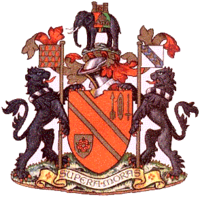
Bolton was, from 1838 to 1974, a local government district in the northwest of England, conterminate with the town of Bolton.
Contents
History
Bolton was created a free borough in 1253 when William de Ferrers, 5th Earl of Derby granted a charter. However the borough did not develop into a self-governing town, remaining under the control of officials appointed by the lord of the manor.[3] By the eighteenth century the town was rapidly expanding and the Bolton Improvement Act 1792 established two local government bodies for the area: the Great Bolton Improvement Trustees, and the Police Commissioners for the Township of Little Bolton[4][5]
In 1838, under the Municipal Corporations Act 1835, the townships of Great Bolton and Little Bolton, along with the Haulgh area from Tonge with Haulgh township, were incorporated as a municipal borough, making it the second to be created in England (after Devonport). However, there was doubt about the validity of the charter, with the local Conservatives refusing to stand for the first council elections, and the magistrates of Salford Hundred disputing the jurisdiction of the new corporation.[6] The first elections to the town council were uncontested, with Whigs and Radicals holding all seats.[7] The council was highly supportive of The People's Charter.[8]
The legality of the charter (as well as those of Devonport, Birmingham and Manchester) was resolved by the Borough Charters Confirmation Act 1842.[9] The Act forced the new municipality to compensate the officers of the old corporation.[3] The first contested elections were held in November, 1842, and Conservatives gained control in 1844.[6][10] In 1850 the borough corporation took over the Great Bolton and Little Bolton trusts established in 1792.[3]
In 1889, as it had a population in excess of 50,000, Bolton was constituted a county borough by the Local Government Act 1888.[11][12] As a county borough, Bolton was independent of the administration of Lancashire County Council, although it remained part of the county for judicial, shrievalty and lieutenancy purposes.
In 1974, under the Local Government Act 1972, the County Borough of Bolton was abolished and its territory transferred to Greater Manchester to form part of the Metropolitan Borough of Bolton.[11][12]
Boundaries and wards
The original borough was divided into six wards: Bradford, Church, Derby, East, Exchange and West.[3] The borough was extended in 1872, taking in the Daubhill area, which became the seventh ward of Rumworth.[3] In 1873 the number of wards was increased to eight, with the formation of a new North ward. In 1877 a further enlargement added the ward of Halliwell.[3][11][12]
The Bolton, Turton, and Westhoughton Extension Act 1898 allowed the county borough to absorb Astley Bridge Urban District and the bulk of Bolton Rural District (the civil parishes of Breightmet, Darcy Lever, Deane, Great Lever, Heaton, Lostock, Middle Hulton, Smithills and Tonge).[11][12][13][14][15] The area added to the borough was divided into eight wards (Astley Bridge, Tonge, Darcy Lever-cum-Breightmet, Great Lever, Hulton, Deane-cum-Lostock, Heaton, and Smithills), increasing the total number to seventeen.[3] The Exchange Ward was subsequently abolished and the borough had sixteen wards until its abolition.[14]
Political control
As noted above, the first elections of the council were uncontested, with Whigs and Radicals forming an administration. Following the entry of Conservative candidates in 1842, they gained a majority in 1844. Until 1887 the only groupings on the council were the majority Conservative and minority Liberal groups, with elections frequently uncontested. The Bolton Engineers' Strike of 1887 led to a highly politicised situation and eight Labour representatives were successful.[16] Three years later the council returned to two-party politics.[17] There was little change over the next decade, although individual Labour and Home Rule candidates were returned.[18][19] From the beginning of the twentieth century a Labour grouping began to emerge. By the 1920s Labour had become the second largest party on the council. The Liberals became the third party, while a Women's Citizen Association councillor sat on the council from 1921 to 1927.[20] In 1933 the Conservatives lost their majority, and the council was under no overall control until 1937.[21] Conservatives regained control in 1937 and held it at the following year's vote. Elections were postponed for the duration of World War II., with the next municipal election being held in 1945. The Labour Party gained 17 seats from both the Conservatives and Liberals, and in 1946 gained control for the first time.[22] The council was then under Labour control until 1949, Conservative from 1949 to 1952 and Labour from 1952 to 1954.[23] After a year under no overall control, Conservatives were in power from 1955 to 1958 and Labour from 1958 to 1961.[24] A Labour-Liberal coalition governed Bolton for two years before Labour regained a majority in 1963[25] The Conservatives regained the borough in 1965 and held it for seven years.[26] In 1972, the final election before the borough's abolition was held, with Labour regaining control.[27]
Demographics
Census population of the County Borough of Bolton Year 1891 1901 1911 1921 1931 1939 † 1951 1961 1971 Population 146,487 168,215 180,851 178,683 177,250 163,823 167,167 160,789 154,223 Sources: (a) Encyclopædia Britannica.[28] (b) Vision of Britain.[29]
† The 1939 population is estimated from the National Registration Act figures.[30] The 1941 census did not take place because of the Second World War.Coat of arms

A coat of arms was associated with the town prior to the borough's incorporation. This consisted of a shield bearing two bendlets or diagonal bands, variously depicted as gold on red or black on gold. The crest above the shield was an elephant bearing a castle on its back.[31] In 1890 Major Otley Parry redesigned the arms for the borough, the new design being officially granted by letters patent from the College of Arms on June 5. The blazon of the arms was as follows:[32]
Gules two bendlets or a shuttle with weft pendent between an arrow point upwards and a mule spinning spindle in chief palewise all of the last and an escutcheon in base of the second thereon a rose of the first barbed and seeded proper, and for a Crest: Upon a rocky moor an elephant statant proper on its back a castle Or and thereon a rose as in the Arms the trapping per pale gules and vert and charged with a mitre also Or.
The bendlets do not seem to have had any particular significance: the corporation claimed that they represented a "soldier's belt".[33] This was a common explanation for the heraldic symbol at the time.[34] A number of symbols were added to the arms. In the upper part of the shield was an arrow, recalling that archers from Bolton played a part at the Battle of Flodden Field in 1513. Next to this were two symbols of the cotton industry: a spindle from Samuel Crompton's spinning mule and a weaver's shuttle. In the lower section of the shield was a gold escutcheon bearing the red rose of Lancaster, denoting that the town was in Lancashire.[32]
The elephant and castle crest of the unofficial arms was retained. The elephant was believed to have been derived from the arms of the City of Coventry, and the green and red colouring of the trappings was taken from the city's arms. The presence of the elephant was explained by the fact that Bolton anciently lay within the Diocese of Mercia, the see of which was at Coventry. The gold mitre in the crest referred to the diocese. The elephant stood on a representation of a "rocky moor": a depiction of the town's old name of Bolton-le-Moors.[33]
In 1958 the corporation received a further grant of supporters and heraldic badge. The additions to the arms were blazoned as follows:
Supporters: On either side a lion sable gorged with a wreath argent and sable each supporting a staff Or flying therefrom a banner that on the dexter vair Or and gules that on the sinister argent on a bend azure three stags' heads caboshed Or; Badge or Device: Upon an oval gules encompassed by a garland of six roses also gules barbed seeded and leaved proper an arrow point upwards enfiled by a crown palisado Or.[35]
The black lions came from the arms of Flanders, in recognition of the fact that Flemish immigrants founded Bolton's textile industry. They supported flags bearing the arms of the two families who held the Earldom of Derby and principal manors of Bolton: the Ferrers and Stanley families.[3][32]
The motto adopted was Supera Moras or "Overcome Delays". It was a pun on the Latin name of the town: "Bolton-super-Moras".[33]
Bolton Corporation Transport
In 1880 Bolton Corporation began the construction of a network of horse tramways in conjunction with the councils of the neighbouring urban districts of Astley Bridge, Farnworth and Kearsley. The services were leased to a private operator, and by 1898 had reached 31 miles in length.[36] In 1897 the corporation gained powers to operate the tramways themselves, and began the process of electrification. The corporation officially took over operation on January 1, 1900, with horse traction ending on the following day. Later the same year the tram lines were extended to Horwich.[36] In 1902 the sections in Farnworth and Kearsley were taken over by Farnworth Urban District Council, who passed operation to South Lancashire Transport in 1906. In 1909 Bolton and SLT began a joint-running arrangement with corporation trams reaching Atherton and Leigh as well as Farnworth and Kearsley.[36] The tramways continued to be extended until 1924, and from 1927 Bolton provided some of the trams for South Lancashire's routes.[36]
Bolton first experimented with omnibuses in 1904 - 1907, with steam and petrol-electric vehicles. Motor bus operation began in 1923. Express services followed in 1927, run jointly with operators such as Manchester and salford corporations, the Stalybridge Hyde Mossley and Dukinfield Transport Board and Lancashire United Transport.[36] The first tramway replacement by buses was in 1933, and the last Bolton tram ran on March 29, 1947.[36] Bolton Corporation continued as a bus-only operation until it was acquired by the SELNEC PTE on November 1, 1969. One Bolton Corporation Transport bus, a 1956 Leyland PD2, is preserved at the Museum of Transport Manchester.[36]
Utilities
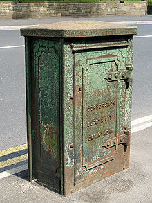 A Corporation Electricity Department box in Bury Road, Breightmet
Water supply
In 1847 the corporation took over the privately-owned waterworks.[3] The main concern of the water undertaking was to secure supplies of water for manufacturing industry, as the existing hard water was damaging boilers.[37] In 1864 they also acquired the Turton and Entwistle Reservoir, contained by the Entwistle Dam for the supply of drinking water.[38] In 1971 the Jumbles Reservoir in the Bradshaw Valley was opened.[39] The County Borough Corporation supplied water to a number of neighbouring authorities including the municipal boroughs of Farnworth, Radcliffe and Swinton and Pendlebury, and the urban districts of Kearsley, Turton, Westhoughton and Worsley[40] Under the Water Act 1973 the undertaking passed to the North West Water Authority.[41]
Electricity
Electric lighting was introduced by the Corporation in 1894.[3] The original power station, in Spa Road, was found to be inadequate, and a new facility and Back o' th' Bank Power Station came into service in 1914.[42] Under the Electricity Act 1947 the electricity supply and generating industry was nationalised, and Bolton's Electricity Department was merged in North Western Electricity Board.[43]
Gas
In 1872 the Corporation acquired the Bolton Gas Light and Coke Company, which dated from 1818. Taken over were works at Gas Street/Moor Lane and Lum Street, with headquarters at Hotel Street. The Corporation reconstructed the works and built a new facility at Spa Road comprising offices, workshops and testing rooms.[38] In 1949, under the terms of the Gas Act 1948, the undertaking passed to the North Western Gas Board.
Neighbouring districts
The former districts which had surrounded the County Borough of Bolton. North-West:
Horwich Urban DistrictNorth:
Turton Urban DistrictNorth-East:
Tottington Urban DistrictWest:
Blackrod Urban DistrictBolton County Borough East:
Radcliffe Urban District
Little Lever Urban DistrictSouth-West:
Westhoughton Urban DistrictSouth:
Tyldesley Urban DistrictSouth-East:
Farnworth Municipal BoroughSee also
References and notes
- ^ Civic Heraldry of England and Wales, including Bolton County Borough. URL accessed 9 May 2008.
- ^ a b Vision of Britain - Bolton CB/MB: Area (acres). URL accessed 26 November 2007.
- ^ a b c d e f g h i j "Townships - Great Bolton". A History of the County of Lancaster: Volume 5. British History Online. 1911. http://www.british-history.ac.uk/report.aspx?compid=53037. Retrieved 2008-07-07.
- ^ "Records of the Great Bolton Improvement Trustees". Access to Archives. The National Archives. http://www.nationalarchives.gov.uk/A2A/records.aspx?cat=125-tgb&cid=-1&Gsm=2008-06-18. Retrieved 2008-07-07.
- ^ "Records of the Little Bolton Improvement Trustees". Access to Archives. The National Archives. http://www.nationalarchives.gov.uk/A2A/records.aspx?cat=125-tlb&cid=-1&Gsm=2008-06-18. Retrieved 2008-07-07.
- ^ a b Malcolm Hardman, Classic Soil : Community, Aspiration, and Debate in the Bolton Region of Lancashire, 1819-1845, Bolton, 2003
- ^ Municipal Elections, The Times, November 4, 1839, p.4
- ^ The Times, August 26, 1839, p4
- ^ Borough Charters Confirmation Act 1842, C.101
- ^ Municipal Elections, The Times, November 5, p.3
- ^ a b c d Bolton Museums and Archive Service - Bolton County Borough. URL accessed 6 July 2007.
- ^ a b c d "Greater Manchester Gazetteer". Greater Manchester County Record Office. Places names - B. http://www.gmcro.co.uk/Guides/Gazeteer/gazzb.htm. Retrieved 6 July 2007.
- ^ "Bolton County Borough Records". Access to Archives. The National Archives. http://www.nationalarchives.gov.uk/a2a/records.aspx?cat=125-ab&cid=0. Retrieved 2008-07-07.
- ^ a b F A Youngs Jr., Guide to the Local Administrative Units of England, Vol.II: Northern England, London, 1991
- ^ Links in a Chain - Bolton 1838-2008. URL accessed 8 May 2008.
- ^ The Municipal Elections, The Times, November 3, p.10
- ^ The Municipal Elections, The Times, November 3, 1890, p.7
- ^ The Municipal Elections, The Times, November 2, 1892, p.6
- ^ The Municipal Elections, The Times, November 2, 1894, p.6
- ^ The Municipal Elections, The Times, November 3, 1919 p.5 and November 2, 1927, p.14
- ^ The Municipal Elections, The Times November 2, 1933 p.14 and November 3, 1937 p.19
- ^ The Municipal Elections, The Times November 3, 1945 p.2 and November 2, 1946 p.2
- ^ The Times, May 13, 1949, p.3; May 9, 1952, p.3; May 14, 1954, p.3
- ^ The Times, May 13, 1955 p.13; May 9, 1958, p.6; May 12, 1961, p.6
- ^ The Times, May 10, 1963
- ^ The Times, May 8, p.10
- ^ The Times, May 5, 1972
- ^ Encyclopedia Britannica, 11th Edition - Bolton, including population figures for 1891 and 1901. URL accessed 26 November 2007.
- ^ Vision of Britain - Bolton CB/MB: Total Population. URL accessed 26 November 2007.
- ^ National Registration Act, 1939. Rootsweb.com. URL accessed 8 June 2007.
- ^ "Coat of Arms". Access to Archives. bolton.org.uk. http://www.bolton.org.uk/coat.html. Retrieved 2008-07-21.
- ^ a b c "Bolton County Borough Council". Civic Heraldry of England and Wales. http://www.civicheraldry.co.uk/lancs_ob.html#bolton%20cbc. Retrieved 2008-07-21.
- ^ a b c C Wilfrid Scott-Giles, Civic Heraldry of England and Wales, 2nd edition, London, 1953
- ^ James Parker, A Glossary of Terms Used in Heraldry, Oxford and London, 1894
- ^ Geoffrey Briggs, Civic and Corporate Heraldry, London , 1972
- ^ a b c d e f g Peter Gould (1999 - 2005). "Bolton Corporation Transport". Local Transport History. http://www.petergould.co.uk/local_transport_history/fleetlists/bolton1.htm. Retrieved 2008-07-21.
- ^ J A Hassan, The Growth and Impact of the British Water Industry in the Nineteenth Century in The Economic History Review, New Series, Vol. 38, No. 4, (Nov., 1985), pp. 531-547
- ^ a b "Entwistle Dam". Engineering Timelines. http://www.engineering-timelines.com/scripts/engineeringItem.asp?id=767. Retrieved 2008-07-21.
- ^ "Jumbles Country Park". Recreation. United Utilities. 1999 - 2005. http://www.unitedutilities.com/?OBH=445&ID=3340. Retrieved 2008-07-21.
- ^ London Gazette: no. 40786. p. 11262. 1956-05-25. Retrieved 2008-07-06.
- ^ The North West Water Authority Constitution Order 1973 (1973 No. 1287)
- ^ "Power Stations in Greater Manchester". Museum of Science and Industry Manchester. 2001. http://www.msim.org.uk/media/159619/power%20stations%20in%20greater%20manchester.pdf. Retrieved 2008-07-21.
- ^ Electricity (Allocation of Undertakings to Area Boards) Order, 1948 (1948 No. 484)
External links
- Bolton CB/MB: Historical Boundaries, (A vision of Britain through time)
Categories:- Local government in Bolton
- Districts of England abolished by the Local Government Act 1972
- County boroughs of England


Wikimedia Foundation. 2010.