Collins Bridge

Collins Bridge
Collins Bridge

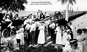
The opening of Collins Bridge, circa 1913.
Crosses Biscayne Bay
Locale Miami to Miami Beach
Design Wooden truss
Total length 2.5 miles (4.0 km)
Opened 1913
Followed by Venetian Causeway
Closed 1925
Coordinates 25°47′21.18″N 80°11′20.77″W / 25.7892167°N 80.1891028°W / 25.7892167; -80.1891028Coordinates: 25°47′21.18″N 80°11′20.77″W / 25.7892167°N 80.1891028°W / 25.7892167; -80.1891028

The Collins Bridge was a bridge that crossed Biscayne Bay between Miami and Miami Beach, Florida. At the time it was completed, it was the longest wooden bridge in the world. It was built by farmer and developer John S. Collins (1837–1928) with financial assistance from automotive parts and racing pioneer Carl G. Fisher. Fisher, an auto parts magnate, loaned Collins $50,000 in 1911 ($1.2 million, adjusted for current inflation) to complete the bridge when Collins' money ran out.[1] Collins, then 75 years old, traded Fisher 200 acres of land on Miami Beach for the loan. The 2½ mile wooden toll bridge opened on June 12, 1913,[2] providing a critical link to the newly established Miami Beach, formerly accessible only by a ferry service. The middle of the bridge had a steel lattice truss design, while the ends were primarily wooden, as well as the deck being wooden for the entire length.[3]

The original wooden causeway was replaced in 1925 by a series of arch drawbridges and renamed the Venetian Causeway.

References

External links


Wikimedia Foundation. 2010.

Игры ⚽ Поможем решить контрольную работу

Look at other dictionaries:

  • Collins Street, Melbourne — Collins Street Looking down Collins Street from Southern Cross Station Length: 2 km (1 mi) Location: Melbourne C …   Wikipedia

  • Collins John — Personal information Full name Collins John Date of birth 17 October 1985 (198 …   Wikipedia

  • Collins House (Davenport, Iowa) — Collins House U.S. National Register of Historic Places Davenport Register of Historic Properties …   Wikipedia

  • Collins railway station — Via Rail (inter city rail) Station statistics Address Collins, ON Coordinates …   Wikipedia

  • Collins Green railway station — was a railway station in Lancashire, later Cheshire, which was in operation between 1830 and 1951. Contents 1 Opening and location 2 Later history and operating companies 3 Passenger train service …   Wikipedia

  • Collins class submarine — HMAS Rankin, sixth submarine of the Collins class, underway in 2006 Class overview Builders: Australian Submarine Corporatio …   Wikipedia

  • Bridge (music) — This article is about bridges in musical composition. For the component of a musical instrument, see Bridge (instrument). For the benefit concerts organized by Neil Young and wife, see Bridge School Benefit. The ragtime progression (E7 A7 D7 G7)… …   Wikipedia

  • Collins Avenue — Fontainebleau Hotel Collins Avenue runs parallel to the Atlantic Ocean in Miami Beach, Florida, one block west. It is also State Road A1A. Collins Avenue was named for John S. Collins a developer who completed the first bridge connecting Miami… …   Wikipedia

  • Collins, Fresno County, California — Coordinates: 36°51′59″N 119°37′14″W / 36.86639°N 119.62056°W / 36.86639; 119.62056 …   Wikipedia

  • John S. Collins — John Stiles Collins (December 29, 1837 February 11, 1928) was an American Quaker farmer from Moorestown, New Jersey [ [http://www.miamibeach411.com/History/bio collins.htm John Collins Biography] , Miami Beach History. Accessed March 13, 2008.… …   Wikipedia

Share the article and excerpts

Direct link
Do a right-click on the link above
and select “Copy Link”