- Stonebridge, Saskatoon
Infobox Settlement
official_name = Stonebridge
other_name =
native_name =
nickname =
settlement_type = Subdivision or Neighbourhood
motto =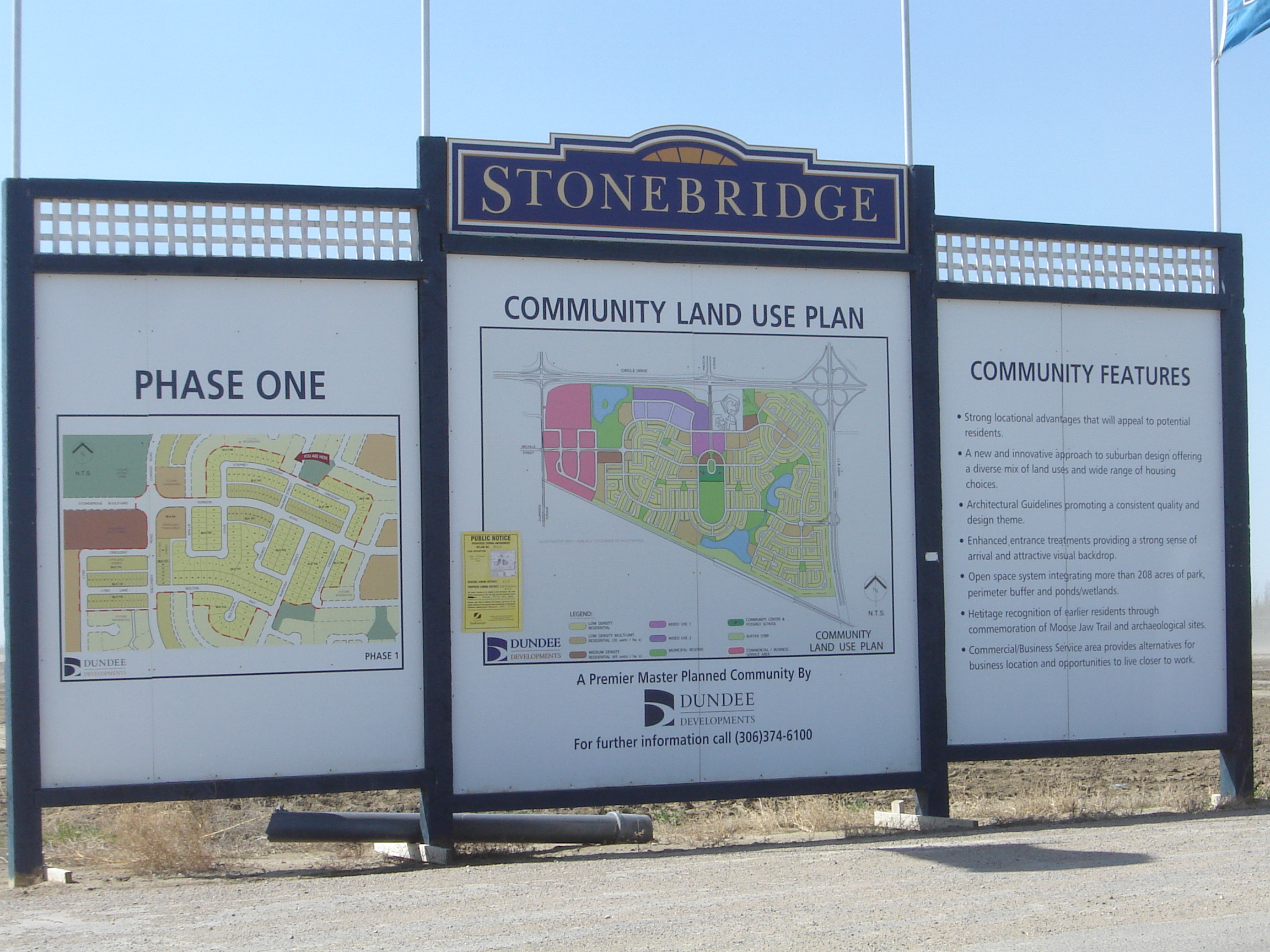
imagesize =
image_caption = Stonebridge Community Plan
flag_size =
image_
seal_size =
image_shield =
shield_size =
city_logo =
citylogo_size =
mapsize =
map_caption =
mapsize1 =
map_caption1 =
image_dot_
dot_mapsize =
dot_map_caption =
dot_x = |dot_y =
pushpin_
pushpin_label_position =
pushpin_map_caption =
pushpin_mapsize =
subdivision_type = Country
subdivision_name = Canada
subdivision_type1 = Province
subdivision_name1 =Saskatchewan
subdivision_type2 = City
subdivision_name2 =Saskatoon
subdivision_type3 = Suburban Development Area
subdivision_name3 = Nutana SDA
subdivision_type4 = Residential Neighbourhood
subdivision_name4 = Stonebridge
government_footnotes = Neighbourhood Association
government_type = Municipal Ward
leader_title = Alderman or councillor
leader_name =
leader_title1 =
leader_name1 =
leader_title2 =
leader_name2 =
leader_title3 =
leader_name3 =
leader_title4 =
leader_name4 =
established_title = Annexed
established_date =1985-1989cite web
last =City Planning Branch, Community Services Department
first =City of Saskatoon
authorlink =
coauthors =
title = Populace Spring 2006
work =
publisher =
date =Volume 8, Issue 1 • Spring 2006
url =http://www.saskatoon.ca/org/city_planning/resources/populace_newsletter/Populace_Spring_2006.pdf
format =
doi =
accessdate = 2007-05-22 ]
established_title2 = Construction
established_date2 = 2005
established_title3 =
established_date3 =
area_magnitude =
unit_pref =
area_footnotes =
area_total_km2 =
area_land_km2 =
area_water_km2 =
area_total_sq_mi =
area_land_sq_mi =
area_water_sq_mi =
area_water_percent =
area_urban_km2 =
area_urban_sq_mi =
area_metro_km2 =
area_metro_sq_mi =
population_as_of = 2006
population_footnotes =
population_note =
population_total = 262
population_density_km2 =
population_density_sq_mi =
population_metro =
population_density_metro_km2 =
population_density_metro_sq_mi =
population_urban =
population_density_urban_km2 =
population_density_urban_sq_mi =
population_blank1_title =
population_blank1 =
population_density_blank1_km2 =
population_density_blank1_sq_mi =
timezone = UTC
utc_offset = -6
timezone_DST =
utc_offset_DST =
latd=52 |latm= 4|lats=46 |latNS=N
longd= 106|longm= 37|longs= 29|longEW=W
elevation_footnotes =
elevation_m =
elevation_ft =
postal_code_type =
postal_code =
area_code =
blank_name =
blank_info =
blank1_name =
blank1_info =
website =
footnotes = City of Saskatoon NeighbourhoodsStonebridge is a primarily residential community currently under development on the south side of the city of
Saskatoon ,Saskatchewan , Canada. Located in the city's Nutana Suburban Development Area, Stonebridge is located south of Circle Drive (Saskatchewan Highway 16 and 11). It is bordered to the west by Clarence Avenue and to the east byLouis Riel Trail (akaSaskatchewan Highway 11 ), though as of the end of 2007 construction is primarily focused on the western half of the district between Clarence and Preston avenues.The southern boundary is the
Canadian National Railway tracks, which delimits this quadrilaterally shaped neighbourhood. Although plans for a residential neighbourhood in the area date back to the early 1980s, construction finally started in 2005. [cite web
last =
first =
authorlink =
coauthors =
title =Selling an Idea or a Product
work =
publisher =
date =
url =http://www.city.saskatoon.sk.ca/org/city_planning/resources/publications/Future_Growth_and_Development_of_Saskatoon.pdf
format =
doi =
accessdate= 2007-10-28 ] This was some two decades after the land was annexed from therural municipality ofCorman Park No. 344, Saskatchewan . Abig box commercial area is currently under development in the northwest corner of the community, including aWal-Mart andHome Depot , and Stonebridge also incorporates Circle Drive Alliance Church and associated seniors residence, which were both built in the late 1970s. Nearby amenities include The Willows Golf and Country Club and Saskatoon Auto Mall. [Citation
last =Point2 Technologies Inc.
first =
author-link =
last2 =
first2 =
author2-link =
title =Saskatoon, Stonebridge
date =1996-2007
year =
url =http://homes.point2.com/Neighborhood/CA/Saskatchewan/Saskatoon/Stonebridge-Real-Estate-Agent.aspx
accessdate = 2007-10-28 As of 2006 there were only approximately 262 residents in this new area. [Citation
last =
first =
author-link =
last2 =
first2 =
author2-link =
title =Neighborhood Profiles
date =
year =
url =http://www.city.saskatoon.sk.ca/org/city_planning/resources/neighbourhood_demographics/brevoort_park.pdf
accessdate = 2007-10-28 A business park is also being developed on the western side of Stonebridge, just east of Clarence Avenue.Transportation
As a result of the increased traffic south of Circle Drive, a new Clarence Avenue and Circle Drive interchange was constructed providing an arterial roadway overpass of Clarence Ave over Circle Drive. Construction began in 2006 was completed by the end of 2007. [cite web
last =
first =
authorlink =
coauthors =
title =City of Saskatoon · Departments · Infrastructure Services ...
work =
publisher =
date =
url =http://www.saskatoon.ca/org/municipal_engineering/construction/Clarence_Circle/index.asp
format =
doi =
accessdate = 2007-10-28 ] A further interchange at Circle Drive and Preston Avenue will also be built, though the City of Saskatoon has yet to finalize a construction timetable. Long-term plans call for Victor Road to be constructed as a new access road into the eastern half of Stonebridge, connecting with Louis Riel Trail/Highway 11 via an interchange.Geography
The roads are laid out in a court system styling. Not all roads are named as of this date, however the initial naming system is presented thusly:
*Alm Crescent
*Assaly Crescent, Bay
*Blackstock Crescent
*Borlase Cove
*Brainerd Crescent
*Chubb Cove
*Cope Crescent, Lane, Way
*Cornish Road
*Dulmage Crescent
*Fawcett Crescent
*Galloway Road
*Gordon Road
*Hartley Road, Terrace
*Hettle Cove
*Laycock Crescent
*LeValley Crescent
*Lewin Crescent
*Lynd Crescent, Lane, Place
*Martin Crescent
*McBeth Crescent
*McIntosh Crescent
*Milne Crescent
*Robertson Cove
*Stepney Crescent
*Stonebridge Boulevard
*Victor Road
*Wellman Crescent
*Willis Crescent, Lane, Way [cite web
last =
first =
authorlink =
coauthors =
title =City of Saskatoon City of Saskatoon · Departments · Community Services · City Planning · ZAM Maps
work =
publisher =
date =
url =http://www.saskatoon.ca/org/city_planning/zam_maps/037.pdf
format =
doi =
accessdate = 2007-10-28 ]Government and politics
Stonebridge exists within the federal electoral district of Blackstrap. It is currently represented by
Lynne Yelich . [cite web
last =
first =
authorlink =
coauthors =
title =Voter Information Service -
work = Elections Canada
publisher =
date =
url = http://www.elections.ca/scripts/pss/InfovoteMain_ne.aspx?L=e&ED=47011&EV=99&EV_TYPE=6&PC=S7K6N9&Prov=&ProvID=&MapID=&QID=-1&PageID=21&TPageID=
format =
doi =
accessdate = 2008-08-261]Provincially, the area is within the constituency of
Saskatoon Southeast . It is currently represented by the HonourableDon Morgan . [cite web
last =
first =
authorlink =
coauthors =
title =Provincial Constituency Boundaries: City of Saskatoon
work = Elections Saskatchewan
publisher =
date =
url = http://www.elections.sk.ca/constituency.php?cID=48&page=mla-1&PageID=21&TPageID=
format =
doi =
accessdate = 2008-08-261] [cite web
last =
first =
authorlink =
coauthors =
title =CTI
work =
publisher =
date =
url = http://www.textiles.ca/eng/IssPolContacts/7601.cfm
format =
doi =
accessdate = 2008-08-261]In Saskatoon's non-partisan municipal politics, Stonebridge is a new area of Saskatoon, lies within ward 7. It is currently represented by Bob Pringle. [cite web
last =
first =
authorlink =
coauthors =
title =City of Saskatoon · City Council · Ward Councillors · Ward 7 - Councillor Bob Pringle
work =
publisher =
date =
url = http://www.briarwoodca.com/
format =
doi =
accessdate = 2008-08-261] Due to population rise since the 2006 census, the city wards are being remapped. Quotation|She's asking the province to allow Saskatoon to use other population estimates in drawing ward boundaries to capture residential development thats happened since 2006, particularly in Stonebridge, the Willows, and Hampton Village.|Janice Mann City clerk, and municipal wards commission. [Citation
last = Nickel
first = Rod
author-link =
last2 =
first2 =
author2-link =
title = City wards being remapped East-side neighborhoods show population growth - Man asking province to allow city to use other estimates
newspaper =The StarPhoenix
pages = Front Page
year = 2008
date = Tuesday, August 26, 2008
url = http://www.canada.com/saskatoonstarphoenix/]Economy
The
big box retail development, the Stonegate Shopping Centre, is located on the west side of the community with Wal-Mart and Home Depot as the anchors. The next closest major retail is the Market Mall shopping centre to the north.chools
The planned layout for the community includes provisions for both public and separate (Catholic) school sites, but as of 2008 no school construction announcements have been made.
Location
[ [http://www.city.saskatoon.sk.ca/org/city_planning/resources/publications/Future_Growth_and_Development_of_Saskatoon.pdf Selling an Idea or a Product] URL accessed January 27, 2007]North: Adelaide/Churchill - Nutana Park - Eastview West: CN Industrial Stonebridge East: Saskatchewan Highway 11 South: Corman Park No. 344, Saskatchewan References
External links
* [http://www.saskatoon.ca/org/city_planning/zam_maps/index.asp City of Saskatoon City of Saskatoon · Departments · Community Services · City Planning · ZAM Maps]
* [http://www.saskatoon.ca/org/city_planning/resources/populace_newsletter/Populace_Spring_2006.pdf Populace Spring 2006]
* [http://www.stonebridgecommunity.ca/ Developer's Website]
Wikimedia Foundation. 2010.