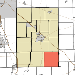
- Noble Township, Shelby County, Indiana
-
Noble Township — Township — Coordinates: 39°23′25″N 85°40′44″W / 39.39028°N 85.67889°WCoordinates: 39°23′25″N 85°40′44″W / 39.39028°N 85.67889°W Country United States State Indiana County Shelby Government – Type Indiana township Area – Total 36.41 sq mi (94.3 km2) – Land 36.38 sq mi (94.23 km2) – Water 0.03 sq mi (0.07 km2) Elevation[1] 820 ft (250 m) Population (2000) – Total 1,438 – Density 39.52/sq mi (15.26/km2) FIPS code 18-54144[2] GNIS feature ID 453674 Noble Township is one of fourteen townships in Shelby County, Indiana. As of the 2000 census, its population was 1,438.
References
- ^ "US Board on Geographic Names". United States Geological Survey. 2007-10-25. http://geonames.usgs.gov. Retrieved 2008-01-31.
- ^ "American FactFinder". United States Census Bureau. http://factfinder.census.gov. Retrieved 2008-01-31.
External links
Municipalities and communities of Shelby County, Indiana City Towns Edinburgh‡ | Fairland | Morristown | St. Paul‡
Townships Addison | Brandywine | Hanover | Hendricks | Jackson | Liberty | Marion | Moral | Noble | Shelby | Sugar Creek | Union | Van Buren | Washington
Unincorporated
communitiesBeech Brook | Bengal | Blue Ridge | Boggstown | Brookfield | Candleglo Village | Clover Village | Crestmoor | Fenns | Flat Rock | Fountaintown | Freeport | Geneva | Green Meadows | Gwynneville | Hildebrand Village | Knighthood Grove | Knighthood Village | Lewis Creek | London | London Heights | Marietta | Marion | Meiks | Meltzer | Middletown | Mount Auburn | Norristown | Pleasant View | Pleasure Valley | Prescott | Rays Crossing | Sleepy Hollow | Smithland | Southeast Manor | Sugar Creek | Waldron
Footnotes ‡This populated place also has portions in an adjacent county or counties
Categories:- Townships in Shelby County, Indiana
- Indianapolis-Anderson-Columbus geography stubs
Wikimedia Foundation. 2010.

