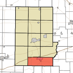
- Cloverdale Township, Putnam County, Indiana
-
Cloverdale Township — Township — Coordinates: 39°30′02″N 86°47′41″W / 39.50056°N 86.79472°WCoordinates: 39°30′02″N 86°47′41″W / 39.50056°N 86.79472°W Country United States State Indiana County Putnam Government - Type Indiana township Area - Total 46.15 sq mi (119.53 km2) - Land 45.66 sq mi (118.26 km2) - Water 0.49 sq mi (1.27 km2) Elevation[1] 784 ft (239 m) Population (2000) - Total 3,847 - Density 84.25/sq mi (32.53/km2) FIPS code 18-13870[2] GNIS feature ID 453235 Cloverdale Township is one of thirteen townships in Putnam County, Indiana. As of the 2000 census, its population was 3,847.
References
- ^ "US Board on Geographic Names". United States Geological Survey. 2007-10-25. http://geonames.usgs.gov. Retrieved 2008-01-31.
- ^ "American FactFinder". United States Census Bureau. http://factfinder.census.gov. Retrieved 2008-01-31.
External links
Municipalities and communities of Putnam County, Indiana City Towns Townships Unincorporated
communitiesBarnard | Belle Union | Brick Chapel | Brunerstown | Cagle Mill | Carpentersville | Clinton Falls | Edgewood Lake | Fincastle | Fox Ridge | Groveland | Hirt Corner | Keytsville | Limedale | Manhattan | Morton | Mount Meridian | New Maysville | Pleasant Gardens | Portland Mills | Putnamville | Raab Crossroads | Raccoon | Reelsville | Vivalia
Categories:- Townships in Putnam County, Indiana
- Indiana geography stubs
Wikimedia Foundation. 2010.

