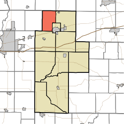
- Dick Johnson Township, Clay County, Indiana
-
Dick Johnson Township — Township — Location of Dick Johnson Township in Clay County Coordinates: 39°33′53″N 87°09′49″W / 39.56472°N 87.16361°WCoordinates: 39°33′53″N 87°09′49″W / 39.56472°N 87.16361°W Country United States State Indiana County Clay Government – Type Indiana township Area – Total 21.61 sq mi (55.97 km2) – Land 21.51 sq mi (55.7 km2) – Water 0.1 sq mi (0.27 km2) Elevation[1] 646 ft (197 m) Population (2000) – Total 1,338 – Density 62.21/sq mi (24.02/km2) FIPS code 18-18118[2] GNIS feature ID 453265 Dick Johnson Township is one of eleven townships in Clay County, Indiana. As of the 2000 census, its population was 1,338.
Contents
Geography
Dick Johnson Township covers an area of 21.61 square miles (56.0 km2); 0.1 square miles (0.26 km2) (0.46 percent) of this is water.
Cities and towns
- Brazil (northwest edge)
Unincorporated towns
(This list is based on USGS data and may include former settlements.)
Adjacent townships
- Raccoon Township, Parke County (north)
- Jackson Township, Parke County (northeast)
- Van Buren Township (east)
- Brazil Township (southeast)
- Posey Township (south)
- Nevins Township, Vigo County (west)
Major highways
Cemeteries
The township contains six cemeteries: Archer, Carter, Orchard, Perth, Saint Marys and Sampson.
References
- "Dick Johnson Township, Clay County, Indiana". Geographic Names Information System, U.S. Geological Survey. http://geonames.usgs.gov/pls/gnispublic/f?p=gnispq:3:::NO::P3_FID:453265. Retrieved 2009-09-24.
- United States Census Bureau cartographic boundary files
- ^ "US Board on Geographic Names". United States Geological Survey. 2007-10-25. http://geonames.usgs.gov. Retrieved 2008-01-31.
- ^ "American FactFinder". United States Census Bureau. http://factfinder.census.gov. Retrieved 2008-01-31.
External links
Municipalities and communities of Clay County, Indiana City Towns Carbon | Center Point | Clay City | Harmony | Knightsville | Staunton
Townships Brazil | Cass | Dick Johnson | Harrison | Jackson | Lewis | Perry | Posey | Sugar Ridge | Van Buren | Washington
Unincorporated
communitiesArt | Ashboro | Asherville | Barrick Corner | Bee Ridge | Benwood | Billtown | Billville | Bogle Corner | Bowling Green | Brunswick | Buchanan Corner | Cardonia | Cloverland | Coalmont | Cory | Cottage Hill | Eel River | Hoffman Crossing | Hoosierville | Howesville | Lap Corner | Middlebury | Old Hill | Perth | Poland | Pontiac | Prairie City | Purdy Hill | Roadman Corner | Saline City | Shady Lane | Six Points | Stearleyville | Turner | Twin Beach
Categories:- Townships in Clay County, Indiana
- Terre Haute metropolitan area
Wikimedia Foundation. 2010.

