- Sunset Tunnel
-
For the Oregon highway tunnel formerly known as the Sunset Tunnel, see Dennis L. Edwards Tunnel.
Sunset Tunnel 
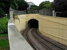
The N Judah entering the eastern portal of the Sunset Tunnel Overview Line Location San Francisco, California, Coordinates 37°46′4.12″N 122°26′26.74″W / 37.7678111°N 122.4407611°WCoordinates: 37°46′4.12″N 122°26′26.74″W / 37.7678111°N 122.4407611°W System Muni Metro Start Duboce Avenue and Noe Street End Carl and Cole Streets No. of stations 0 Operation Opened October 21, 1928 Owner San Francisco Municipal Transportation Agency (SFMTA) Operator San Francisco Municipal Railway (Muni) Character Light rail Technical Line length 4,232 ft (1,289.91 m) No. of tracks double Gauge 4 ft 8 1⁄2 in (1,435 mm) Standard gauge Electrified Overhead lines, 600 V DC Tunnel clearance 23 ft (7.01 m) The Sunset Tunnel is a tunnel in San Francisco, California, used by the N Judah Muni Metro line. It opened on 21 October 1928 in a ceremony presided over by Mayor James Rolph,[1] and lies directly beneath Buena Vista Park and the steep hill that the park is located on. The western entrance to the tunnel is located near the intersection of Carl and Cole Streets in Cole Valley. The eastern entrance is at Duboce and Noe Streets, in the Duboce Triangle neighborhood adjacent to Duboce Park.
Access to the tunnel is restricted to San Francisco Municipal Railway light rail trains only. Despite the limitations of entering the tunnel, this tunnel is not well protected, and is constantly vandalized and graffiti-strewn. The length of the tunnel from portal to portal is 4120 ft.
See also
References
San Francisco Municipal Railway Muni Metro Muni Metro system features Other Muni services Current projects Future projects Agencies and organizations Connecting services Museums Other information Categories:- San Francisco Municipal Railway
- Railroad tunnels in California
- Tunnels in San Francisco, California
- Tunnels completed in 1928
- United States rail transportation stubs
Wikimedia Foundation. 2010.


