- Robertson Tunnel
Infobox tunnel
name = Robertson Tunnel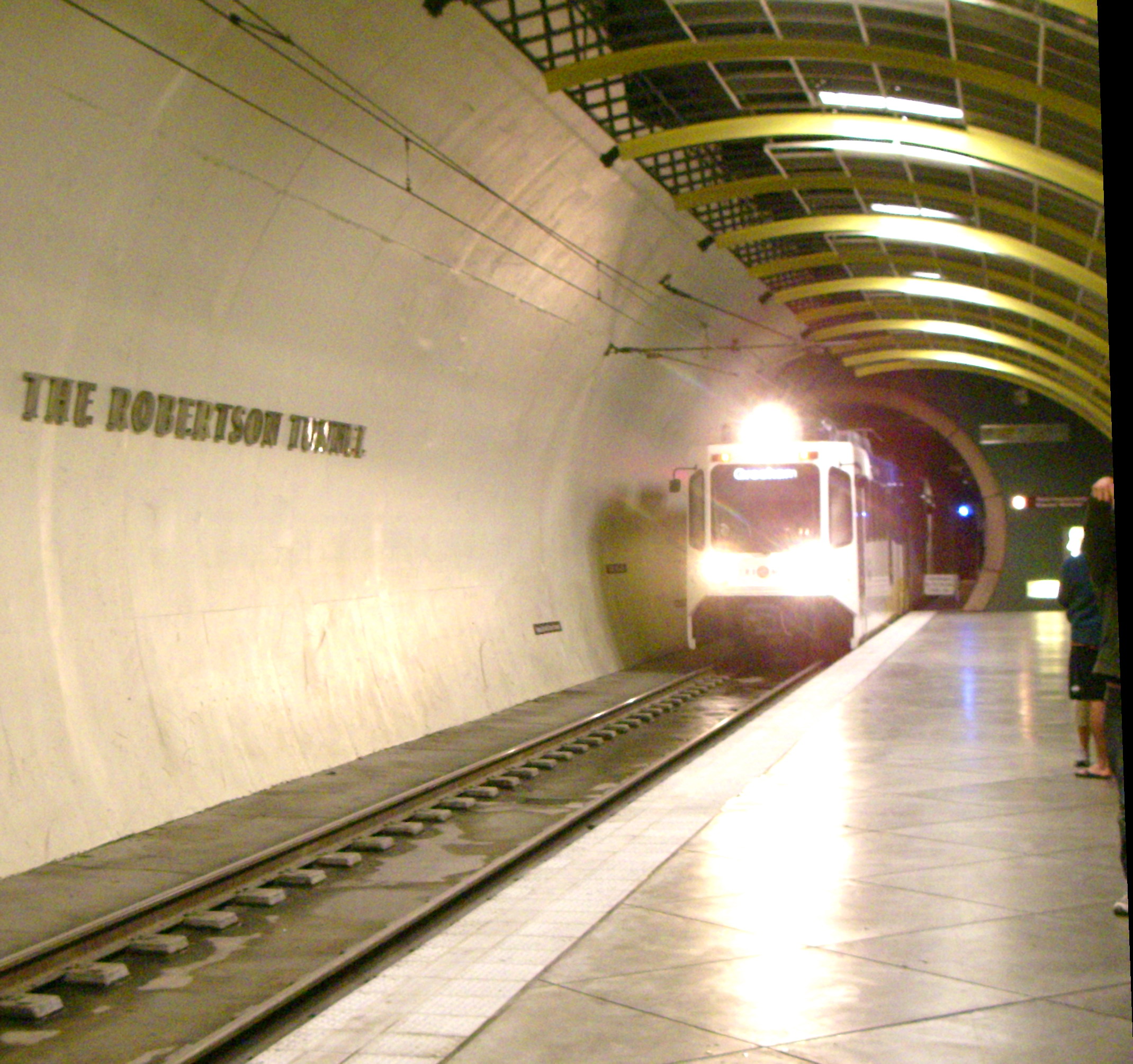
caption = Robertson Tunnel is named mid-platform in the Washington Park station
line = westsideMAX Blue Line
location =Tualatin Mountains ,Portland, Oregon ,USA coord|45.510661|-122.716869|display=title,inline
system =MAX Light Rail
start = Goose Hollow coord|45.519087|-122.699749
end = Sunset Hills Mortuary coord|45.506324|-122.753833
stations = 1
status = in service
open =September 12 1998
close =
owner =TriMet
operator =
character = passenger commuter
linelength = 18 mi (29 km)
tracklength = 3.1 mi (5.0 km)
notrack =double track
gauge = RailGauge|sg [ cite web
url = http://ktransit.com/transit/uspnw/portland/pdx_lr.htm
title = Portland Transit—MAX Light Rail
author = Mark Kavanagh
publisher = Kavanagh Transit Systems
accessdate = 2007-07-30 ]
el = overhead 750 Vdc [ cite web
url = http://onlinepubs.trb.org/onlinepubs/circulars/ec058/14_03_Pham.pdf
format =PDF
title = Traction Power Supply for the Portland Interstate MAX Light Rail Extension
author = Kinh D. Pham, Elcon Associates, Inc.
coauthors = Ralph S. Thomas & Xavier Ramirez, LTK Engineering Services
publisher =Transportation Research Board
accessdate = 2007-07-29 ]
speed = 55 mph (90 km/h)
hielevation = 450 ft
lowelevation= 250 ftFact|date=July 2007|The Robertson Tunnel is a
tunnel through the west hills ofPortland, Oregon ,U.S. for theTriMet public transitMAX Light Rail system. The tunnel is 3.1 miles (5.0 km) long and consists of twin 21 foot (6.4 m) diameter tunnels. There is one station within the tunnel at Washington Park, the second deepest such station in the world. The tunnel has won several worldwide engineering and environmental awards. [ cite web
url = http://www.trimet.org/about/awards.htm
title = Awards & Recognition
publisher =TriMet
accessdate = 2007-07-30 ] It was placed into serviceSeptember 12 1998 . [ cite web
url = http://www.trimet.org/about/history/westblueline.htm
title = Westside MAX Blue Line Project History
publisher =TriMet
accessdate = 2007-07-30 ]The tunnels pass through
basalt up to 16 million years old. Due to variations in the rock composition, the tunnel curves mildly side to side and up and down to follow the best rock construction conditions. cite web
url = http://www.trimet.org/pdfs/history/railfactsheet-westside.pdf
title = Westside light rail—the MAX Blue Line extension
accessdate = 2007-07-26 ] The tunnels vary from 80 to 300 feet (24–91 m) below the surface. A core sample taken during construction is on display with a timeline of local geologic history. [ cite web
url = http://world.nycsubway.org/us/portland/max-blue.html
title = Portland MAX: East-West MAX (Blue)
publisher = world.nycsubway.org
accessdate = 2007-08-03 ] The east tunnel entrance is nearVista Bridge at the edge of the Goose Hollow neighborhood at the foot of Washington Park. The west entrance is along U.S. Route 26 just west of the Finley-Sunset Hills cemetery, about a mile east of the junction withOregon Route 217 . cite web
url = http://www.light1998.com/U_S_Air-Force-Tunnel-Boring-Machine/Sam's-Light-Rail-Page-Tunnels-&-Engineering.htm
title = Tunneling and Civil Engineering
author = Sam's
accessdate = 2007-07-26 ]Name
The tunnel is named for William D. Robertson who served on the TriMet board of directors and was its president at the time of his death.
History
Originally, it was expected that the westside MAX line would be adjacent to the Sunset Highway, despite the six percent average grade. Reliability, weather conditions, public opinion, and environmental concerns led to choosing to tunnel through the
Tualatin Mountains instead.Construction began in the summer of 1993 at the west end employing the conventional mining technique of
drilling and blasting due to the loose mixture of materials. More than 75 tons of explosives were used and mining progressed about a mile into the hill. East end construction began in August 1994 with a customizedtunnel boring machine . About a thousand workers from 230 construction firms were involved in the 18 mile westside MAX line, including those who built the tunnel and installed the reinforced concrete liner, tracks and wiring. One worker was killed while operating equipment.Tunnel construction continued 24 hours a day, six days per week. The north tunnelers met after 16 months on
December 29 1995 , and the boring machine began the south tunnel in April 1996. The south tunnel took only four months before the tunneling teams met onAugust 15 1996 .To complete the west end at the cemetery, 14 bodies were relocated.
The original estimate for the tunnel was $103.7 million, but the final price tag came to $184 million, largely due to challenges posed by unexpected loose layers of silt and gravel, and crumbling basalt which prevented the boring machine from working effectively.
Route
The tunnel generally follows, but remains north of U.S. Route 26, diverging the most (1/3 mi, 500 m) in the
Oregon Zoo area.The elevation at the west end is higher than the east but there is very little perceptible slope except for several gentle, short grades which exist presumably to follow the easiest-to-bore rock stratum.
During construction, the east portal was west of
Canyon Road , below City of Portland Reservoir 4. After completion, the road was raised and an overpass placed over the track. This effectively extends the tunnel about 430 ft (130 m) so it emerges on the east side of Canyon Road.Beginning at the east end (traveling westward), under Canyon Road the tunnel turns SSW (202°) [The tunnel was tracked on [http://mapper.acme.com/?ll=45.51031,-122.72144&z=17&t=T TopoZone data on ACME Mapper] . The angle was measured using Photoshop. The angles are expressed in conventional navigational
cardinal direction values.] for about 300 m (1000 ft) where it turns WSW (236°) under the large field east of the Elephant House. 1200 m (4000 ft) later it is directly under and follows SW Kingston Road at a point 250 m (800 ft) north of the zoo's elephant exhibit. For the next 250 m, it arcs until almost directly westward (263°) and straightens for 300 m (1000 ft) to arrive at the Washington Park station.After the station, it passes under the south side of the
World Forestry Center 's main building and turns 4° northward (267°) and continues for its longest straight stretch of 900 m (3000 ft). At the point it passes under SW Skyline Road 150 m (500 ft) north of the Sylvan Bridge, it turns slightly southward (253°) and—300 m (1000 ft) later—goes under the Finley-Sunset Hills building and water feature. For the remaining 500 m (1700 ft), it turns right in a long gradual arc exactly paralleling Sunset Hwy. The arc continues at the same rate after the west portals, and is due west (270°) about 500 m (1700 ft) past the portals.See also
*
List of tunnels in the United States
*List of tunnels by location References
External links
* [http://gsa.confex.com/gsa/2001AM/finalprogram/abstract_24156.htm Portland's Westside light rail tunnel]
Wikimedia Foundation. 2010.