- Norland, West Yorkshire
-
Coordinates: 53°41′59″N 1°54′07″W / 53.699729°N 1.901942°W
Norland 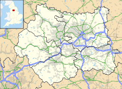
 Norland
Norland shown within West YorkshireOS grid reference SE065225 Metropolitan borough Calderdale Metropolitan county West Yorkshire Region Yorkshire and the Humber Country England Sovereign state United Kingdom Post town SOWERBY BRIDGE Postcode district HX6 Dialling code 01422 Police West Yorkshire Fire West Yorkshire Ambulance Yorkshire EU Parliament Yorkshire and the Humber UK Parliament Calder Valley List of places: UK • England • Yorkshire Norland is a scattered village to the south of Sowerby Bridge in the metropolitan borough of Calderdale in West Yorkshire, England.
Contents
History
The settlement dates back to the 13th century and consisted originally of timber-framed farmhouses situated on the hillside above the valleys of the Calder and Ryburn rivers. These were gradually replaced in the 17th and 18th centuries by stone houses that mainly housed workers of the woollen industry which developed in the area at this time. As the industry thrived, some of the houses built by yeoman farmers were very substantial and remain excellent examples of their type, such as Lower Old Hall (dated 1634) and Fallingworth Hall (dated 1642). Norland Hall, lower down on the hillside near Milner Royd, was typical of an older timber-framed building encased in stone in the late 17th century. In 1911 it was struck by lightning and dismantled in 1914. The American newspaper magnate William Randolph Hearst bought the stones in 1922 with the intention of re-building the hall in the USA. However, his plan came to nothing and eventually some of the material was incorporated into a chapel in San Simeon, California, in 1968.
The village has a church, St. Luke's, which opened in 1866. Three other places of worship, Mount Pleasant Methodist Chapel (1819–1962), Mount Zion Chapel and Bethel Baptist Chapel (1865-?), are now all private residences.
The primary school was originally built as a Sunday School in 1871 and opened as a Church of England day school in January 1872. It has since been extended twice (1894 and 2003).
The War Memorial was erected in 1920 and the park around it created four years later on the site of the old village pinfold. In 2000 a millennium sundial was added and a time capsule buried by the children of Norland school.
Norland Moor
Norland Moor (approx. 250 acres) above the village is a rare example of heather moorland, which rises to 284 metres (932 ft) at the trig point at the southern end. There is evidence of ancient use with a small number of standing stones, ditches and banks having been identified. The Ladstone, a large outcrop near the trig point, has been linked with the Druids as a possible place of ritual sacrifice (Celtic llad = kill or cut). The moor also bears the scars of quarrying on the north-western edge, which was carried out chiefly in the 18th and 19th centuries. The moor has been a popular place of recreation for generations but it has also attracted illegal gambling dens and prize fights! Previously owned by Lord Savile, a large section of the moor was put up for auction in 1932 in order to pay death duties. The moor was purchased by local resident Mr Francis Longbottom for £250. Subsequently the Parish Council launched an appeal (which raised £373 in eleven days)and Norland Moor passed by dint of public subscription into the care of the Parish Council for the benefit of the local population. In 1937 control passed to Sowerby Bridge Urban District Council and then in 1974 into the newly formed Calderdale Metropolitan Borough Council. In 2002 Norland Moor was designated a Local Nature Reserve (LNR). In 2011 moves are in place to create a Friends of Norland Moor group so that local interests are still respected in the moor's management.
Norland today
Norland today has an estimated population of about 600 (compared to about 1500 in the mid 19th century). Most people commute out of the village to work. It no longer has any shops but has one public house, "The Moorcock" and the Norland Working Men's Club at Ivy Cottage in Stormer Hill Road, reputedly one of the smallest working men's clubs in the country. "The Blue Ball", dating back to at least the 1820s, closed in December 2009, and "The Hobbit" (previously "The West Bottom Tavern") closed in 2011.
Norland Scarecrow Festival
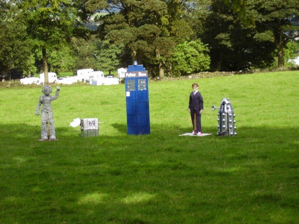
The annual Norland scarecrow festival was instigated by a millennium committee for the village in 1999. It takes place on and around the first weekend in September. Every year a different theme for the event is set and many houses in the village create scarecrows along the lines of this theme and compete for the prize of best scarecrow. The theme for 2011 is Pop Stars and Groups.[3][4]
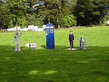 Four Doctor Who themed scarecrows from the 2007 festival
References
- ^ Watson, John (Revd.) (1775). The History of the parish of Halifax.
- ^ "Norland Scarecrow Festival". http://www.norlandscarecrows.co.uk.
- ^ "Norland Scarecrow Trail, September 2005". BBC Bradford & West Yorkshire. BBC. 2005. http://www.bbc.co.uk/bradford/going_out/2005/norland/01.shtml. Retrieved 2009-08-25.
- ^ "Scarecrow Festival". Evening Courier. Johnston Press Digital Publishing. 10 March 2009. http://www.halifaxcourier.co.uk/barkisland/Scarecrow-Festival.5053976.jp. Retrieved 2009-08-25.
- ^ Bateman, Charles (15/06/1968). Halifax Evening Courier & Guardian.
- ^ Kendal, H P (1905, 1911). Transactions of Halifax Antiquarian Society.
- ^ Giles, Colum (1986). Rural Houses of West Yorkshire. HMSO. pp. 207–209.
External links
 Media related to Norland, West Yorkshire at Wikimedia CommonsCategories:
- Villages in West Yorkshire
- Geography of Calderdale

Wikimedia Foundation. 2010.