- New York State Route 631
-
NYS Route 631
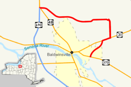
Map of northwestern Onondaga County with NY 631 highlighted in redRoute information Maintained by NYSDOT, Onondaga County and the town of Lysander Length: 5.05 mi[2] (8.13 km) Existed: June 1999[1] – present Major junctions South end:  NY 370 in Baldwinsville
North end: 
 NY 48 / NY 690 in Lysander
Location Counties: Onondaga Highway system Numbered highways in New York
Interstate • U.S. • N.Y. (former) • Reference • County←  NY 598
NY 635  →
→New York State Route 631 (NY 631) is a state highway in Onondaga County, New York. The southern terminus is at NY 370 in Baldwinsville. The northern terminus is at NY 48 and NY 690 just north of Baldwinsville.
Contents
Route description
Route 631 begins at NY 370 near the eastern edge of Baldwinsville. The route heads northward through Lysander, paralleling the Baldwinsville village line to an intersection with NY 31. The two routes briefly overlap for one-half mile before separating at Lysander's Radisson Community. Past NY 31, NY 631 heads northward as the four-lane Willett Parkway, then bears west onto the two-lane West Entry Road, acting as a bypass of northeast Baldwinsville. Proceeding west, it crosses an industrial railroad siding while turning slightly south, then west again.[3]
Just west of the siding, NY 631 intersects Sixty Road (CR 140) as it becomes known as Hencle Boulevard. NY 631 continues on, crossing the CSX Transportation-owned Baldwinsville Subdivision ahead of an intersection with County Route 229 adjacent to Lysander Park. West of CR 229, the route curves to the northwest and meets NY 48 northwest of Baldwinsville. NY 48 and NY 631 briefly overlap a junction with the northern terminus of NY 690, where NY 631 ends.[4]
Maintenance of NY 631 varies along the route. From NY 370 to NY 31, as well as on the portions that overlap other state routes, maintenance on NY 631 is performed by the New York State Department of Transportation.[5] Between CR 140 and NY 48, the roadway is maintained by Onondaga County as County Route 95.[6] From NY 31 to CR 140, maintenance is performed by the town of Lysander.[7]
History
NY 631 was assigned in June 1999[1] to a series of pre-existing roadways[6] between NY 31 and the intersection between NY 48 and NY 690. It was extended south to NY 370 in late 2001.[1]
Major intersections
The entire route is in Onondaga County.
Location Mile[2] Destinations Notes Baldwinsville 0.00 NY 3700.78  NY 31 west
Western terminus of NY 31 / NY 631 overlap Lysander 1.27 NY 31 eastEastern terminus of NY 31 / NY 631 overlap NY 48 southEastern terminus of NY 48 / NY 631 overlap 5.05 NY 48 north / NY 690Western terminus of NY 48 / NY 631 overlap; northern terminus of NY 690 1.000 mi = 1.609 km; 1.000 km = 0.621 mi References
- ^ a b c Sinsabaugh, Mark. "New York State Route 631". New York Routes. http://www.gribblenation.net/nyroutes/ind/600_699.htm#631. Retrieved September 9, 2007.
- ^ a b "2008 Traffic Volume Report for New York State" (PDF). New York State Department of Transportation. June 16, 2009. p. 242. https://www.nysdot.gov/divisions/engineering/technical-services/hds-respository/NYSDOT%20TVR%202008%20by%20Route.pdf. Retrieved January 29, 2010.
- ^ Google, Inc. Google Maps – first overview map of New York State Route 631 (Map). Cartography by Google, Inc. http://maps.google.com/maps?hl=en&q=from:+RT-631%20S/Willett%20Pkwy%20@43.168282,%20-76.300400+to:+W%20entry%20Rd/RT-631%20@43.178070,%20-76.316440. Retrieved February 14, 2008.
- ^ Google, Inc. Google Maps – second overview map of New York State Route 631 (Map). Cartography by Google, Inc. http://maps.google.com/maps?hl=en&q=from:+W%20entry%20Rd/RT-631%20@43.178070,%20-76.316440+to:+Hencle%20Blvd/RT-631%20@43.185550,%20-76.359350. Retrieved February 14, 2008.
- ^ New York State Legislature. "New York State Highway Law § 341". http://public.leginfo.state.ny.us/menugetf.cgi?COMMONQUERY=LAWS. Retrieved January 29, 2010.
- ^ a b New York State Department of Transportation (1989). Baldwinsville Digital Raster Quadrangle (Map). 1:24,000. http://www.nysgis.state.ny.us/gisdata/quads/drg24/dotpreview/index.cfm?code=o28. Retrieved January 29, 2010.
- ^ "Onondaga County Inventory Listing" (CSV). New York State Department of Transportation. October 1, 2009. https://www.nysdot.gov/divisions/engineering/technical-services/hds-repository2/INV_2009-10-01_Onondaga.csv. Retrieved January 29, 2010.
External links
Categories:- State highways in New York
- Transportation in Onondaga County, New York


Wikimedia Foundation. 2010.