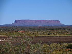
- Mount Conner
-
Mount Conner 
Mount Conner seen from the road to UluruElevation 859 m (2,818 ft) AHD Location Location Northern Territory, Australia Coordinates 25°29′49″S 131°54′00″E / 25.497°S 131.900°ECoordinates: 25°29′49″S 131°54′00″E / 25.497°S 131.900°E Mount Conner, also known as Attila and Artilla,[1][2] and occasionally found as Mount Connor, is an Australian mountain located in the southwest corner of the Northern Territory, 75 kilometres (47 mi) southeast of Lake Amadeus at the border of the vast Curtin Springs cattle station. It reaches to 859 metres (2,818 ft)[1] above sea level and to 300 metres (984 ft) above ground level.
Mount Conner is a flat-topped and horseshoe-shaped inselberg, part of the same vast rocky substrate thought to be beneath Uluru/Ayers Rock and Kata Tjuta/Olgas. It can easily be confused with Uluru, since it can be seen from the road to Uluru and Kata Tjuta, when approaching from Alice Springs. It was named Mount Conner by William Gosse in 1873 after South Australian politician M. L. Conner.[2]
Geology
The sedimentary layers of Mount Conner were deposited in a shallow sea during the Neoproterozoic Era (1Ga to 542Ma) in the then Centralian Superbasin, which was divided in several sub-basins at the end of the Neoproterozoic. The rock of Mount Conner is 200My to 300My older than Uluru/Ayers Rock and Kata Tjuta/Olgas.[3] The surrounding layers of sedimentary rock eroded preferentially to those of Mount Conner leaving the mesa/inselberg that is seen today.
References
- ^ a b "Mount Conner". Gazetteer of Australia online. Geoscience Australia, Australian Government. http://www.ga.gov.au/bin/gazd01?rec=116377.
- ^ a b "Mount Conner". Encyclopædia Britannica Online. Encyclopædia Britannica. 2011. http://www.britannica.com/EBchecked/topic/133031/Mount-Conner.
- ^ Connelly, Daniel P (2009). "The case for a massive Australian Precambrian/Cambrian impact structure (MAPCIS)". Abstracts with Programs (Geological Society of America) 41 (3): 38. http://gsa.confex.com/gsa/2009NE/finalprogram/abstract_153541.htm.
Additional sources
- Northern Territory Geological Survey (1967). Ayers Rock Geology Map (Map). 1:250,000. Sheet SG52-8 (1st ed.).
- Northern Territory Geological Survey (2002). Ayers Rock Geology Map (Map). 1:250,000. Sheet SG52-8 (2nd ed.).
- Johnson, David (2004). The Geology of Australia. Cambridge University Press. ISBN 0-521-84121-6. http://books.google.com/books?id=kdJNcKi3SakC&dq=0521841216.
- Thompson, R B (1995). A Guide to the Geology and Landforms of Central Australia. Alice Springs: Northern Territory Geological Survey. ISBN 0-7245-2527-0. http://www.nt.gov.au/d/Minerals_Energy/Geoscience/Content/File/Pubs/GeolLandFormsCenAust.pdf.
Categories:- Mountains of the Northern Territory
Wikimedia Foundation. 2010.
